|

Understanding through Discussion |
|
|
Register | Sign In |
|
QuickSearch
| Thread ▼ Details |
|
Suspended Member (Idle past 1474 days)  Posts: 35298 From: Nevada, USA Joined: |
|
Thread Info
|
|
|
| Author | Topic: Evidence that the Great Unconformity did not Form Before the Strata above it | ||||||||||||||||||||||||||||||
Faith  Suspended Member (Idle past 1474 days) Posts: 35298 From: Nevada, USA Joined: |
What you said was, "I have never used ANY biblical interpretation." READ WHAT I WROTE IN THE POST ABOVE THAT, IN Message 1551.CONTEXT CONTEXT CONTEXT. Sorry, I didn't see your request not to respond. Edited by Faith, : No reason given.
|
||||||||||||||||||||||||||||||
|
ThinAirDesigns Member (Idle past 2403 days) Posts: 564 Joined: |
Faith writes: The layer IS separated at the contact lines both above and below, where the shadows are, although some try to pretend they are not separated. I'm still trying to figure out what you mean by "separated". Are you saying that there is an air gap (a cave of sorts) between the two layers? JB
|
||||||||||||||||||||||||||||||
|
Faith Suspended Member (Idle past 1474 days) Posts: 35298 From: Nevada, USA Joined: |
Yes.
|
||||||||||||||||||||||||||||||
|
Admin Director  Posts: 13046 From: EvC Forum Joined: Member Rating: 2.7 |
Faith writes: What you said was, "I have never used ANY biblical interpretation."
READ WHAT I WROTE IN THE POST ABOVE THAT, IN Message 1551.CONTEXT CONTEXT CONTEXT. I did read what you wrote. I've read every word of all your messages. You derive your ideas out of a need to reconcile the Bible with the real world. You're on record as saying that science only interprets the natural world while the Bible tells us what really happened, and that where science and the Bible disagree that science is wrong, that it is false science. So if you want to cry "CONTEXT CONTEXT CONTEXT" then this is the context you have set. Please, no replies to this message.
|
||||||||||||||||||||||||||||||
|
Admin Director Posts: 13046 From: EvC Forum Joined: Member Rating: 2.7 |
Hi Faith,
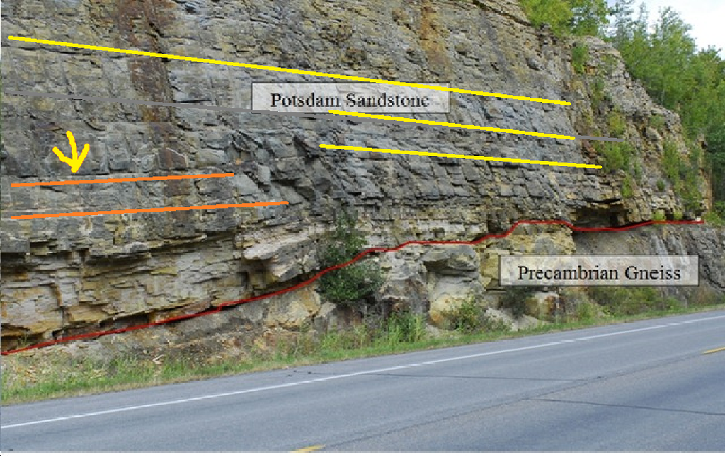
I was asking what you see in this image that leads you to conclude that it could not have happened any other way but as you describe, and how you eliminate other possibilities such as having been deposited on a slope:
As I'm only trying to clarify and not participate in the discussion, I'll only touch on those parts of your reply that mention evidence in some way, or assertions that are missing evidence:
Faith writes: The argument is completely about the lower left hand corner where the layer sags down into a depression in the gneiss. What evidence are you looking at that tells you it sagged? How did you eliminate the possibility that the layers were deposited upon a sloping landscape? How did you eliminate the possibility of tectonic forces? How did you eliminate isostatic depression and rebound?
It even LOOKS plastic, like damp clay. There seems no rock anywhere in the image that resembles damp clay, which looks like this, for example:
The layer IS separated at the contact lines both above and below,... What evidence are you looking at that tells you this separation is a quality of the layers that extends back into the rock face? How did you eliminate the possibility that it's a surface feature that is the result of blasting and erosion?
The layer in question is evenly thick where it sags on the left but is "pinched out" over the gneiss on the right, which also means it had to have been soft at the time. If you're referring to where the red line jogs upward for a short bit in the right half of the image, earlier we presented Google Street View images of the road cut that led Edge and I to conclude that that jog is likely misdrawn, that there is likely no jog upward in the layers at that point.
In the teeth of the obvious somebody will insist it deposited that way, which is ridiculous. The whole area tilts to the left, including the rock above with its tight contact line. It's a denial of the obvious reality but that's all they've got. I hope I can do the sand experiments in June but it shouldn't be necessary, the rock is evidence enough. This brings us back to a point that was raised earlier but for which I do not think an answer was ever provided. It concerned this image:
Sedimentation descends evenly from above in (a). In (b) is shown your interpretation of what would result. In (c) is shown geology's interpretation. Can you describe what mechanism you are imagining that would cause (b), where the sand would have had to flow like water in order to pool at the lowest point? Edited by Admin, : Grammar.
|
||||||||||||||||||||||||||||||
|
ThinAirDesigns Member (Idle past 2403 days) Posts: 564 Joined: |
Faith writes: Yes. How big are these "caves"? How did they form? How widespread are they? And most importantly, what is the evidence for them? (because these "caves" don't exist in the picture as much as your muddled eyesight wants to see them) JB
|
||||||||||||||||||||||||||||||
|
Faith Suspended Member (Idle past 1474 days) Posts: 35298 From: Nevada, USA Joined: |
You'd have to get up very close with a camera and light to those "caves" to see if there is a tight contact line inside them.
But since you want to argue about that, how about noticing the very straight and tight but tilted contact line at the top of the layer above the sagged layer(s)? Something caused it to tilt after all the strata were laid down (same thing that caused the layer below to sag of course). Or are you going to argue that that too was deposited just like that, extremely straight though on a slight tilt, although it would have been deposited on top of a curved sagged surface? Edited by Faith, : No reason given. Edited by Faith, : No reason given.
|
||||||||||||||||||||||||||||||
|
ThinAirDesigns Member (Idle past 2403 days) Posts: 564 Joined: |
Faith writes: You'd have to get up very close with a camera and light to those "caves" to see if there is a tight contact line inside. Wait, just a couple posts ago you responded with a very assertive "Yes" when asked about the "caves", but now you're clearly saying you can't know if they are caves without being up close with lights and a camera? It's really hard to figure out your position when it ping pongs. Is your position now that you can't tell or are there caves?
|
||||||||||||||||||||||||||||||
|
ThinAirDesigns Member (Idle past 2403 days) Posts: 564 Joined: |
Faith writes: ...how about noticing the very straight and tight but tilted contact line at the top of the layer above the sagged layer(s)? Need marked drawing to respond. Want to be sure we're talking about the same thing.
|
||||||||||||||||||||||||||||||
|
Faith Suspended Member (Idle past 1474 days) Posts: 35298 From: Nevada, USA Joined: |
What evidence are you looking at that tells you it sagged? How did you eliminate the possibility that the layers were deposited upon a sloping landscape? It's one of a stack of horizontally deposited layers. The tilt on the left obviously occurred after the stack was all laid down: see very straight slightly tilted contact line on layer above. I never think in terms of layers deposited on a slope. This is the Stratigraphic Column. There are no such layers. They all deposited horizontally and deformations occurred after they were laid down, in example after example. Deformation means plasticity which requires that the rock not yet be lithified. The layer did not break, it sagged.
How did you eliminate the possibility of tectonic forces? I didn't. I suppose that it was tectonic force that messed up the gneiss and disturbed the layers above, especially on the left where they tilt and sag.
How did you eliminate isostatic depression and rebound? Ooooo, edgy type snow job there. That would of course have affected the entire stack for miles around, not just the left hand corner of this little piece of it. But playing along, it would have depressed while soft while all the layers were there anyway, same scenario just a different source of disturbance. And excuse me but you can't prove that sedimentation on a slope acts as you claim based on a diagram. However, I WOULD point out that even in your diagram it's thicker in the lowest part, but that is not the case in our photo, it's quite evenly thick, as it would be if originally deposited horizontally.
|
||||||||||||||||||||||||||||||
|
Faith Suspended Member (Idle past 1474 days) Posts: 35298 From: Nevada, USA Joined: |
Sigh. They look like broken contacts to me and I'd bet you about it, But since you are inclined to argue I'll just require you to prove your argument. That would take light and a camera for a good closeup.
|
||||||||||||||||||||||||||||||
|
edge Member (Idle past 1736 days)  Posts: 4696 From: Colorado, USA Joined: |
Okay, I'm not going to debate a picture. There's too much going on from perspective, to blasting damage, to shadows, to geological history. Sometimes, I think we are talking about different parts of the picture, or even different pictures.
The real issues are Faith's blunders of knowledge and interpretation of the constellation of geological data surrounding the Great Unconformity.
It's one of a stack of horizontally deposited layers. The tilt on the left obviously occurred after the stack was all laid down: see very straight slightly tilted contact line on layer above.
If there is actual folding or deformation, I would expect it to propagate into the upper layers.
I never think in terms of layers deposited on a slope. This is the Stratigraphic Column.
No, it is a road cut in the local stratigraphy.
There are no such layers. They all deposited horizontally and deformations occurred after they were laid down, in example after example. Deformation means plasticity which requires that the rock not yet be lithified. The layer did not break, it sagged.
Factually wrong. To a geologist, all rocks are plastic.
I didn't. I suppose that it was tectonic force that messed up the gneiss and disturbed the layers above, especially on the left where they tilt and sag.
So, how do you explain the vast difference in deformation and metamorphic grade of the gneiss versus the sandstone?
|
||||||||||||||||||||||||||||||
|
Faith Suspended Member (Idle past 1474 days) Posts: 35298 From: Nevada, USA Joined: |
Yellow lines indicate horizontal. Orange lines on the left indicate the tilt downward to the left from the horizontal of the contacts above the sagged layers.
|
||||||||||||||||||||||||||||||
|
edge Member (Idle past 1736 days) Posts: 4696 From: Colorado, USA Joined: |
Sigh. They look like broken contacts to me and I'd bet you about it, But since you are inclined to argue I'll just require you to prove your argument. That would take light and a camera for a good closeup.
This is why I have decided not to debate a photograph, particularly with a person who has poor vision. I will, however, say that the only times I have seen such a phenomenon are where there has been erosion or dissolution of the underlying layer. If this happened as Faith says, particularly before lithification, something would be deposited in the space created.
|
||||||||||||||||||||||||||||||
|
Faith Suspended Member (Idle past 1474 days) Posts: 35298 From: Nevada, USA Joined: |
If this happened as Faith says, particularly before lithification, something would be deposited in the space created A bit of rubble perhaps. Just not a nice tight contact.
|
||||||||||||||||||||||||||||||
|
|
Do Nothing Button
Copyright 2001-2023 by EvC Forum, All Rights Reserved
![]() ™ Version 4.2
™ Version 4.2
Innovative software from Qwixotic © 2024