Take a look at the Susquehana; north of Harrisburg and note how it chose to flow through mountain ranges instead of around them. The other rivers do the same trick. Does anyone have any explanations?
I don't know the river you're talking about, so I can't deal in specifics here, but here's one possible explanation. Maybe the river system predates the mountains. If a pre-existing river can downcut faster than a mountain range can rise, it will carry on through.
Another explanation is headwater erosion and stream capture.
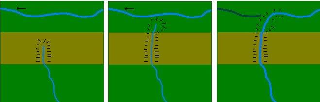
At the top, there's a plain with a river system flowing west. South of that is a mountain range, and south of the mountains is a plain lower than the northernmost one. A river developed on the mountains and cut a valley backwards until it reached the northern plain. Eventually it breaches the channel of the northern river, which then follows the new path of least resistance southwards, leaving part of it's old course dry.
I don't really see what's illogical about this.
What's your explanation then?