|

Understanding through Discussion |
|
|
Register | Sign In |
|
QuickSearch
Summations Only | Thread ▼ Details |
|
Thread Info
|
|
|
| Author | Topic: Why the Flood Never Happened | ||||||||||||||||||||||||||||||||||||||||||||||
|
Percy Member  Posts: 22505 From: New Hampshire Joined: Member Rating: 5.4
|
Faith writes: I have NOT claimed that ALL boundaries are knife-edged. I don't think you could even find a place where I misspoke about that. Yes, that's true, but what you said back in Message 83 was this:
Faith in Message 83 writes: ...depending on the local situation the fact that completely different sediments are laid one upon another, which defies any slow normal-time explanation, the fact that the interface between the layers, which may be totally different sediments, most often shows a knife-edge close contact, no blurring between them,... So if some strata have knife-edged boundaries and some don't, how is that evidence that "defies any slow normal-time explanation"? You continue:
...whatever small degree of erosion that may be seen there being explainable as runoff between the layers; For strata where there was continuous deposition across the boundary region there will never be any erosion. Erosion will only be apparent at unconformities. The most common cause of an unconformity is uplift followed by erosion of the exposed strata followed by subsidence followed by deposition onto the eroded strata. And I have to ask again: How do you imagine runoff occurring on a submerged landscape? --Percy
|
||||||||||||||||||||||||||||||||||||||||||||||
|
Percy Member Posts: 22505 From: New Hampshire Joined: Member Rating: 5.4
|
Faith writes: It did. It is deeply eroded. But it was a whole block of tilted layers not "just a few." That is really a very large formation which is indicated on all the cross sections. I don't think we're saying anything different or talking about two different things. If you look at this diagram again:
You'll see that the Grand Canyon supergroup has four layers, which is just a few, while it is overlain by eleven layers. And I wasn't implying anything about its size.
Nothing in Wikipedia about the Great Unconformity suggests that it is anything more than a local event... Quoting from the Wikipedia article on the Great Unconformity:
Wikipedia writes: The "great" unconformities of regional or continental scale (in both geography and chronology) are associated with either global changes in eustatic sea level or the supercontinent cycle, the periodic merger of all the continents into one approximately every 500 million years.... Powell's Great Unconformity is part of a continent-wide unconformity that extends across Laurentia, the ancient core of North America. The Great Unconformity at the Grand Canyon is just one of a number of places where this ancient continent-wide unconformity is exposed. Whatever you imagine happened at the Grand Canyon to tilt the layers would have had to have also happened across the entire continent.
But of course that is the standard interpretation which I'm pointedly disputing, saying the erosion was caused by the abrasion between the Supergroup and the Tapeats. The top layer of the supergroup is the Sixtymile Formation, and so your scenario holds that at one time the Sixtymile Formation was horizontal and underlay the Tapeats. Then tectonic forces tilted the supergroup layers, but somehow had no effect on the Tapeats, which wasn't deformed in any way. The layers above were equally unaffected. There is nothing that would stop the forces acting on the supergoup to suddenly stop at the underside of the Tapeats.
I have to suppose that the abraded material from the Supergroup is under the canyon, out of the picture or maybe part of the unidentified material shown on the cross sections. The supergroup used to be rectangular in cross section, then it tilted and lost around 40% of its volume. Your scenario requires cubic miles and miles of rock to just disappear into thin air. The abraded material that you imagine would have had no way to move. Were material abraded from the supergroup, it would still be there. The reason it's not still there is because the supergroup was tilted, exposed to the elements at the surface, then eroded away.
I already answered you about layers turning to "rock." They hardened enough to be stable. I assume they are rock by now. Because I reject the idea of millions of years for just about any process. So if they weren't yet rock when the overlying layers eroded away, then since those overlying layers provided the necessary pressure to turn sedimentary deposits to rock, those layers could never have become rock. Therefore the upper strata could not have been eroded away before the lower strata became rock. Or consider the Claron layer. Obviously it is solid rock now, but it was once one of the layers above the layers at the Grand Canyon whose weight helped turned those layers to rock. If it needed to be soft in order to be eroded away above the Grand Canyon, then this same layer couldn't be solid as a rock today over at Brian Head.
The upland lake you claim was too small was a superlake like the Missoula and the Lahonton, very high and very large, all lakes which wre most likely water left over from the Flood. The breaking of the dam of the Missoula carved out a river canyon in that area too. Yes, I knew you were referring to the glacial superlakes. There was nothing particularly high in elevation about them, and they didn't contain sufficient water to erode thousands of square miles of rock column a mile thick, not even close. Also, we already know that Missoula drained through Washington State, not Arizona, and that Lahontan evaporated. The kind of evidence that the glacial lakes left behind when they drained is the same kind of evidence found in Washington State. There is none of that kind of evidence in the region around the Grand Canyon. The more relevant question is why you feel the need to go through all these machinations. The flood was an act of God and requires no natural explanation. When you look at the tilted supergroup and wonder how it happened and where all the material went, how come the answer isn't, "God." --Percy
|
||||||||||||||||||||||||||||||||||||||||||||||
|
Percy Member Posts: 22505 From: New Hampshire Joined: Member Rating: 5.4
|
Faith writes: The Supergroup is actually nine layers but I thought it was more and it doesn't really matter anyway. But this is from Wikipedia:
The ...Grand Canon Supergroup of sedimentary units is composed of nine varied geologic formations... The oldest section of the supergroup is the Unkar Group We were looking at this diagram that shows 4 major layers in the supergroup:
It can be divided into sublayers, but they aren't shown in the diagram. The sublayers of the overlying strata aren't shown in the diagram either.
Look at the contact line between the Tapeats and the Supergroup: sure looks to me like the Tapeats was affected or the line would be straight. The sedimentary layers of the supergroup were at one time just the bottommost layers of a deep stack of layers. Stretching of the continent split these layers up into blocks, which then tilted to fill in the space created by the stretching. Periods of uplift and erosion wore these tilted layers down to nubs just a few layers thick. The exposed tilted edges of the layers eroded very unevenly and presented a rugged landscape. We see the bottommost remains of two of these blocks as supergroup strata beneath the Grand Canyon in this diagram:
The region then subsided beneath the waves of a shallow sea and sedimentation began anew, filling in the lowest areas first to form the Tapeats.
Yes, the weight of two miles of strata above would be the resistance that happened to stop at the Tapeats Layers tilting over while still buried isn't possible because no mechanism could do this, the evidence doesn't indicate it happened, and it requires thousands of cubic miles of sedimentary rock to just disappear. --Percy
|
||||||||||||||||||||||||||||||||||||||||||||||
|
Percy Member Posts: 22505 From: New Hampshire Joined: Member Rating: 5.4
|
Hi Faith,
I anticipated this question up above in my Message 274:
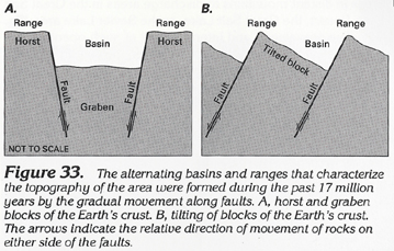
Faith writes: 2) What caused the TILTING of the Supergroup? You haven't replied to this message, so I don't know if you've seen it yet, but let me answer the question again. I don't know why RAZD answered "Earthquakes." The tilting of the layers of the supergroup is a typical basin and range phenomena caused by stretching of a tectonic plate. This happened early in the geologic history of the continent, and it happened again later, the effects of which are copiously visible all over the western United States and Canada. The stretching causes the stratigraphic layers to break up into blocks along vertical faults. The blocks then lean slightly. Here's a rough illustration of the process from the Wikipedia article on the Basin and Range Province:
The diagram is primitive and obviously hand drawn, but it's the best I could find. You should imagine that there are many stratigraphic layers, not just the two shown. The process begins at "A" with horizontal strata. In "B" the underlying plate has stretched, causing roughly vertical fault lines (which in the diagram are curved but need not be) in the strata above. The strata are now split into a series of blocks. In "C" the plate continues to stretch, causing the blocks to slide along the fault lines and tilt to fill the extra space. In "D" the process continues and we see the typical basin and range topography. Here's another image illustrating a couple variations on this theme:
The Grand Canyon supergroup layers are all that remains of an ancient basin and range of the tilted block variety. If you look beneath the Grand Canyon in this diagram you'll see two blocks of supergroup layers that precisely resemble the blocks of typical basin and range formations:
--Percy Edited by Percy, : No reason given.
|
||||||||||||||||||||||||||||||||||||||||||||||
|
Percy Member Posts: 22505 From: New Hampshire Joined: Member Rating: 5.4 |
Faith writes: Percy your link that was supposed to go to a message of your own goes to one of mine. Whoops, sorry, fixed now. It was supposed to be Message 274. --Percy
|
||||||||||||||||||||||||||||||||||||||||||||||
|
Percy Member Posts: 22505 From: New Hampshire Joined: Member Rating: 5.4
|
Faith writes: When did the uplift occur in relation to the tilting/erosion of the Supergroup? The uplift had to have occurred after all the layers visible at the Grand Canyon were deposited because layers are deposited horizontally.
If you look at those cross-sections of the Grand Staircase - Grand Canyon area you can see that the uplift over the GC is in a mounded shape, and that the tilted layers of the Supergroup I've been asking you about occur at the bottom of the canyon area directly under the uppermost height of that mounded area. The uplift explains the canyon. While the region gradually uplifted, the Colorado eroded through the elevating landscape. That there are a couple of blocks of supergroup below the canyon has no particular meaning. Uplift and subsidence take place all over world and are due to forces originating from deep within the Earth, far deeper than the bottom of the supergroup. Because it exposes so much of so many geological layers, the Grand Canyon is one of the most studied areas in the world. Perhaps there are no other blocks of supergroup in the area, or perhaps there are and we don't know about them because we've only made intensive studies in the area around the Grand Canyon. --Percy
|
||||||||||||||||||||||||||||||||||||||||||||||
|
Percy Member Posts: 22505 From: New Hampshire Joined: Member Rating: 5.4
|
The granite and schist that underlies the strata in the Grand Canyon region are ancient metamorphic and igneous rock. Metamorphic rock has been subjected to extreme heat and pressure. Igneous rock is magma that has cooled sufficiently to become solid.
I think they represent these basement rocks as gray not because they're all uniformly the same, and not because we don't know anything about them, but because they can't be represented as neatly layered strata. They have a much more complex structure. --Percy
|
||||||||||||||||||||||||||||||||||||||||||||||
|
Percy Member Posts: 22505 From: New Hampshire Joined: Member Rating: 5.4 |
Hi Petro,
I think you exploring the depth of the foundations of my geological knowledge would be a bit off-topic. If you'd like to offer corrections to anything I've explained then please go ahead. --Percy
|
||||||||||||||||||||||||||||||||||||||||||||||
|
Percy Member Posts: 22505 From: New Hampshire Joined: Member Rating: 5.4
|
PaulK writes: - we see slopes in opposite directions. The strata of the GCS slopes up right-to-left, while the ground slopes up left-to-right (the surface of the GCS does have a small left-to-right upward angle, and I suppose THAT could be due to the later uplift). You don't mention it explicitly, so just so no one's confused, in your first image north is to the left, and in the second it is to the right. --Percy
|
||||||||||||||||||||||||||||||||||||||||||||||
|
Percy Member Posts: 22505 From: New Hampshire Joined: Member Rating: 5.4
|
Faith writes: That is, how did erosion cut through the elevating land to cause the canyon? Seems to me more likely that a relatively small amount of water like the Colorado River would just run off the slopes of the mounding uplift rather than cutting into it. Erosion through rock takes time, but uplift also takes time and is usually very slow, perhaps something on the order of a centimeter per year, but not at a constant rate. Whenever uplift outstrips erosion then water pools but eventually spills over and creates a rapid flow, perhaps even a falls, and the fast moving water can erode quickly backward upstream. Niagara Falls is a good example of retreat of a waterfall - it has retreated upstream about 7 miles in the last 10,000 years. The uplift of the region around the Grand Canyon is not thought to have been continuous but episodic and to have taken millions of years. --Percy
|
||||||||||||||||||||||||||||||||||||||||||||||
|
Percy Member Posts: 22505 From: New Hampshire Joined: Member Rating: 5.4 |
PaulK writes: Provided the bending is done incredibly slowly, under high pressure, yes. There is good evidence (distorted fossils) of such things happening elsewhere. You and Faith might be talking about different bending than I am. The bending I'm talking about is in the middle of this diagram just above the supergroup:
The diagram isn't to scale. It ranges across hundreds of miles horizontally and only a few miles vertically, so the bending is very exaggerated. In reality the radius of the bending is hundreds of miles. There would be no detectable distortion of fossils or anything else. When you mentioned distorted fossils it seemed to me that you might be talking about some relatively tight bending. --Percy
|
||||||||||||||||||||||||||||||||||||||||||||||
|
Percy Member Posts: 22505 From: New Hampshire Joined: Member Rating: 5.4
|
Faith writes: Yes, that could work I suppose. Plausible enough based on your OE assumptions, considering that we're all guessing. Downcutting through an uplifting landscape is a frequently observed process in river systems all around the world. Here's a rough diagram I created illustrating the process:
Each line represents the same landscape thousands of years apart. On the top line we see a river cut into the landscape. We're seeing the river edge on. On the next line we see the landscape has uplifted slightly, and the river has eroded down into it and followed the same course. On the third line down we see that the landscape has continued to gradually uplift, and during this uplift the river has continued to gradually erode down into the underlying strata. On the forth line down the landscape has continued to be gradually uplifted to what is at this point a significant amount, and the river has continued to gradually erode down into the underlying strata to form a canyon. And on the bottom line the landscape has again continued to be gradually uplifted to what is now a tremendous amount, and the river has continued to gradually erode into the underlying strata to form a great canyon. --Percy Edited by Percy, : Grammar.
|
||||||||||||||||||||||||||||||||||||||||||||||
|
Percy Member Posts: 22505 From: New Hampshire Joined: Member Rating: 5.4
|
Faith writes: That depends on the river's already flowing before the canyon existed at all,... The river formed the canyon, so by logical necessity it existed before the canyon.
...in the direction you expect it to end up in the eventual canyon it's supposedly already begun to cut, and before the uplift even got started. In the early stages of canyon formation, diversion of the river onto a different path is very likely. We know this because we see rivers changing their courses today, and geologists have found evidence all over the world of the changing paths taken by rivers. But as a river cuts more and more deeply into an uplifting landscape to form the beginnings of an actual canyon, diversion of the river out of the canyon becomes increasing unlikely. In this image of Mississippi River, the riverbanks are only slightly higher than the river, so the river can easily escape the banks and find another route, which geological history tells us it has done many times:
But in this image of the Amur River in Mongolia you can see that once a river has begun to cut down a little into a landscape, diversion onto another course is very unlikely:
It also depends on its already having a nicely barricaded channel to flow in that would keep it from flowing south if the channel is flowing east-west, and if you have any evidence that it WAS already flowing east to west in such a nicely walled channel before the uplift occurred you've got a point. You misunderstood Dr Adequate's diagram. First, it's not a "nicely walled channel". It's a diagram of a normal river made with a drawing tool using straight lines. Second, it doesn't show a canyon, nor was it intended to. It's an illustration of what happens to a normal river when it experiences just a tiny bit of uplift. In case it's not clear, the river should be interpreted as flowing up out of the page.
But of course it's all made up as all this stuff is. None of this is made up. Geologists go out in the field and observe this behavior, and they study it in the lab both with computers and with models like this:
A model like this can quickly illustrate flowing water's ability to quickly erode through a region of mild uplift. --Percy
|
||||||||||||||||||||||||||||||||||||||||||||||
|
Percy Member Posts: 22505 From: New Hampshire Joined: Member Rating: 5.4
|
Faith writes: Funny how uplifts seem to like to push themselves up right beneath a stream of water like that, that has already formed banks that prevent it from spilling down the slope of the mounded uplift, but hey, it's not impossible of course, just not very likely as a general rule. What you appear to be describing isn't what happens, and it isn't what my diagram shows. Take another look at it:
Look at the first line. It shows just a normal river with barely any riverbanks. Now look at the second line. It shows just the slightest uplift and just the slightest erosion down to the same level it occupied on the first line. It didn't have "already formed banks." The riverbanks grew in height as the river eroded its way through the gradually uplifting landscape. This gradual process of simultaneous uplift and erosion continues on subsequent lines, and the riverbanks grow higher and higher as the river erodes downward to maintain the same level, eventually becoming the cliffs of a deep canyon. Those cliffs formed gradually over time and were never "already formed." It would be an error to interpret people as saying that the Colorado River never changed its course over millions of years. That's not what people are saying. What we're saying is that the Colorado River gradually eroded into a gradually uplifting landscape. Undoubtedly it did change course during the earliest stages of uplift, but once the channel became sufficiently deep any significant diversion would have become very unlikely. You're also working under the misimpression that only the area beneath the Grand Canyon was uplifted, but if you examine this topographical map of Arizona you'll see that there was an enormous area of uplift stretching all the way from the northern border down through Flagstaff and then continuing further south and east toward New Mexico. It was a huge area that was uplifted. The Grand Canyon is where the Colorado eroded its way down through the gradually uplifting region (the image is huge, you'll have to scroll around):
--Percy
|
||||||||||||||||||||||||||||||||||||||||||||||
|
Percy Member Posts: 22505 From: New Hampshire Joined: Member Rating: 5.4
|
Faith writes: Nope, the OE view is that the meanders were formed before the uplift and were cut as incised meanders. They are quite common, here's an image search.
There couldn't have been meanders in a river a mile deep in a canyon before there was a canyon, and Percy already agreed that the canyon was cut into the uplift. But of course you're free to disagree with him. When JonF said that "the meanders were formed before the uplift" he assumed you understood that this was before the canyon was there. Meanders only form on a very slow flowing river on a very level landscape. Imagine a river flowing across a very flat plain and you'll get something like this image of the Rio Cauto from the Wikipedia article on Meader:
The course of a meandering river is very changeable, but in a gradually uplifting region a meandering river can gradually erode down through rock, forever etching the last meandering pattern into the landscape like RAZD's image, or like this one:
--Percy
|
||||||||||||||||||||||||||||||||||||||||||||||
|
|
Do Nothing Button
Copyright 2001-2023 by EvC Forum, All Rights Reserved
![]() ™ Version 4.2
™ Version 4.2
Innovative software from Qwixotic © 2024

 (1)
(1)