|

Understanding through Discussion |
|
|
Register | Sign In |
|
QuickSearch
Summations Only | Thread ▼ Details |
|
Thread Info
|
|
|
| Author | Topic: Why the Flood Never Happened | ||||||||||||||||||||||||||||||||||||||||||||||||||||||||
|
roxrkool Member (Idle past 1017 days)  Posts: 1497 From: Nevada Joined:
|
I certainly was not prepared for the viciously hostile responses I got.
I am reminded of my interaction with Australian Creationist, Jonathon Safarti, on the TheologyWeb forum. He was eventually banned for his nastiness.
They couldn't care less whether a claim were true or not, just so long as it sounded convincing, the more convincing sounding the better.
That's also why ICR, AIG, and other Creationist organizations like to hire degreed geologists/scientists, they are more "convincing." A degree provides them with increased "credibility," as Faith illustrated perfectly when she cited, "GEOLOGIST Steve Austin." Just because you have a degree in science (or anything else, really), doesn't automatically make you a scientist worth citing or reading. I work with a geologist who has 7 years experience as a mine geologist and this person knows less than both my junior geologists with 2 years experience. The junior geos want to learn and are passionate about what they do. The other one is there for the money and nothing more. In fact, there are people on this forum who are probably better geologists than this guy. So for me, degrees don't mean a damned thing. I want to see what kind of time you put in to increasing your knowledge and improving your skills. I want to see how hard you work, the thought processes you go through to find the answers, and how you put those answers together to get a final (albeit revisable) conclusion. If 2+2 doesn't equal 4, then you're not much of a scientist. Although you could be a geologist... kidding! As far as I've seen, the Creationist geologist has gone into the science for the sole purpose of committing intellectual dishonesty. He is there to win the battle over the mind of the religious layperson. And, of course, the cards are stacked in his favor because his target audience have been trained to have complete faith and never to question their religious leaders. The Creationist geologist doesn't care about science or truth. They are liars. No geologist can get a Ph.D. in geology and fuck up meanders. Edited by roxrkool, : No reason given. Edited by roxrkool, : No reason given.
|
||||||||||||||||||||||||||||||||||||||||||||||||||||||||
|
roxrkool Member (Idle past 1017 days) Posts: 1497 From: Nevada Joined: |
Excellent post! Kudos.
|
||||||||||||||||||||||||||||||||||||||||||||||||||||||||
|
roxrkool Member (Idle past 1017 days) Posts: 1497 From: Nevada Joined: |
That makes absolutely no sense, Faith. Are you suggesting the canyon is evolving independently from the river?
|
||||||||||||||||||||||||||||||||||||||||||||||||||||||||
|
roxrkool Member (Idle past 1017 days) Posts: 1497 From: Nevada Joined:
|
Obviously no one can follow your logic. This is the first post in a series of posts that is starting to make sense.
The problem is you don't know the subject matter very well and every attempt you make to get your point across is hampered by your inability to write in a clear and coherent manner. Now you have to explain and support: 1) timing for when the sediment was lithified and 2) when the river started cutting down into the rock.
|
||||||||||||||||||||||||||||||||||||||||||||||||||||||||
|
roxrkool Member (Idle past 1017 days) Posts: 1497 From: Nevada Joined:
|
What tectonic force after the flood? Rebound? Orogeny? What?
How would water flowing above (and depositing upon?) unconsolidated strata break/crack the underlying strata? Cracking and breaking requires the sediment to be lithified.
|
||||||||||||||||||||||||||||||||||||||||||||||||||||||||
|
roxrkool Member (Idle past 1017 days) Posts: 1497 From: Nevada Joined:
|
Normally, you have pretty good to excellent grammar, but in your last few posts, including this one, it's atrocious. So I'm not going to bother trying to unscramble that mess of a post, not only because it is near impossible to understand, but because what I can understand is simply stupid and not worthy of a reply.
DAMP MODELING CLAY WILL CRACK AND BREAK. Just how much clay occurs in the GC column, Faith? You can't even explain how a FLOOD can create and deposit carbonate, for that matter. And now you're suggesting that the entire GC stratigraphic column is composed of clay. Otherwise, why in the world would you ever assume a big ball of damp modeling clay is an appropriate analog for the GC seds? And by the way, damp clay does not behave the same way as damp sand. I can't even believe that needs saying. Edited by roxrkool, : No reason given.
|
||||||||||||||||||||||||||||||||||||||||||||||||||||||||
|
roxrkool Member (Idle past 1017 days) Posts: 1497 From: Nevada Joined:
|
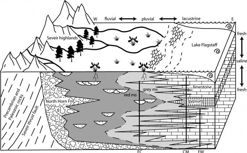
Curiously the only place I can find reference to "Hopi Lake" is in creationist literature. Similar for "Grand Lake" as a prehistoric lake, even though there is a Grand Lake in NW Colorado.
If so, what are the chances these creationists have actual evidence for the presence of these lakes? I also find it curious that the full extent of these lakes are not shown ... perhaps because to do so would expose the existing low points that would have provided outflow.
Lakes that large, that existed in the relatively recent past, will leave evidence, such as wave-cut terraces/benches, beach/shore deposits, etc. Those of us living in the Great Basin (Nevada and Utah) are quite familiar with paleo lacustrine geology in the form of the ancestral predecessor to the Great Salt Lake, Lake Bonneville. It's wave-cut terraces galore out here. Edited by roxrkool, : No reason given. Edited by roxrkool, : No reason given.
|
||||||||||||||||||||||||||||||||||||||||||||||||||||||||
|
roxrkool Member (Idle past 1017 days) Posts: 1497 From: Nevada Joined:
|
Obviously the Missoula floods are the greatest example of this, but I believe you are correct, Jar, only I really have not spent that much time looking into it. We discussed this in school (I went to school in Reno) and spent several field trips looking at these terraces just outside Fallon and Wendover, NV, and I travel to Utah via I-80 quite a bit and you see the terraces all over the place, but I don't recall any flood deposits here.
Let's take a Google look... Well lookee here from THE CATASTROPHIC LATE PLEISTOCENE BONNEVILLE FLOOD IN THE SNAKE RIVER PLAIN, IDAHO, HAROLD E. MALDE, 1968 (PDF file):
quote: The USGS report has great pictures (physical EVIDENCE!) of what these deposits look like.
|
||||||||||||||||||||||||||||||||||||||||||||||||||||||||
|
roxrkool Member (Idle past 1017 days) Posts: 1497 From: Nevada Joined:
|
Which brings up another issue -- whatever happened to the water that must have filled the "Great Basin" -- an area that includes almost all Nevada and half of Utah that has no river outlet. All you have left is Great Salt Lake ... which is not salty enough for the whole basin to have evaporated ...
Much of the water simply evaporated over the last several thousand years as the climate dried out. But the Great Basin does have quite a bit of water in the subsurface as Percy suggested. There are other remnant lakes other than the GSL, such as Pyramid Lake outside of Reno, NV and the now dried up Lake Winnemucca, which had water up until the first half or so of the 20th century. Incidentally, Lake Winnemucca is also the location of the oldest pictographs / petroglyphs in North America. They are pretty spectacular. Driving around the less traveled roads of Nevada, you will see that many of the valleys are dried lake beds. The desert has encroached onto most of the lake deposits, particularly in the central to southern part of the state, but in northern Nevada they are still very visible. The Black Rock desert (Burning Man) is a great and popular example. Edited by roxrkool, : No reason given. Edited by roxrkool, : No reason given.
|
||||||||||||||||||||||||||||||||||||||||||||||||||||||||
|
roxrkool Member (Idle past 1017 days) Posts: 1497 From: Nevada Joined:
|
Wouldn't that leave caves and the like?
Really, the only time you get good cave development is where there is limestone or calcareous rocks. Slightly acidic waters will dissolve the limestone to form open-space caves and/or karsts, and this is usually caused by carbonic, sulfuric, or nitric acids.
|
||||||||||||||||||||||||||||||||||||||||||||||||||||||||
|
roxrkool Member (Idle past 1017 days) Posts: 1497 From: Nevada Joined:
|
that a gigantic rock pancake, that may stretch for hundreds or even thousands of miles across a continent, somehow represents a particular time period in Earth's history, IS ABSURD."
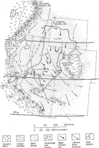
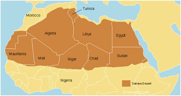
Let's do a quick comparison... The Sahara Desert, which is currently being deposited, and the Navajo Sandstone, which is Jurassic in age and deposited in the western U.S. The interpreted depositional area of the Navajo Sandstone and time-equivalent correlatives:
The Sahara Desert as it occurs today:
Now let's compare the two:
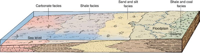
So if we can have a desert the size of the Sahara being deposited today, why could that not have happened in the past? I believe I read somewhere that there were some aeolian units found further East that are suspected to be equivalent to the Navajo as well, making it larger than is known today. Still, even if it covered the entire U.S., it would still be smaller than the contemporary analog. In addition, consider the size of the oceans today. An immense area of the planet is covered by water, which is why most of the rocks we see on the surface of the Earth are marine sedimentary. Reasonable enough. However, with plate tectonics, we know that much of the marine sediments never become rocks exposed on the surface because they are consumed in subduction zones. Sure, we get some marine rocks squeezed onto the continent during subduction, but these are usually so deformed they hardly look like marine rocks anymore. Marine sediments/rocks can be preserved if they once formed inland seaways that were later uplifted (Western Interior Seaway, for example), marine sediments deposited in passive continental margins then uplifted, those brought in via accreted terranes (such as island arcs), and through continental collision (Alps, etc.). Much of the western U.S. is formed through the accretion of island arc terranes, which are primarily composed of marine sedimentary rocks. While we typically do do not see these marine units extending for thousands of miles across continents, they can be fairly extensive depending on their age (the older, the less likely they will survive tectonic upheavals) and where they are located (interior cratonic areas are very stable). I am not a stratigrapher, but petroleum geologists use their knowledge of sequence stratigraphy, geologic evolution of the continents, biostratigraphy, and many other tools to predict the best places to drill. They are successful for a reason. What you don't understand yet is that these "rock pancakes" as you call them, are not necessarily homogeneous across their entire extent. In the case of continental units like the Navajo, the sand grains that form the sandstone will have different compositions depending on where you take a sample. This can tell us that the northern portion of the unit is formed of sand that was sourced say from a granitic terrane, the southern end from clean beach sands, the east end from a metamorphic terrane, the central portion from volcanic rocks. All of which will have their own particular mineralogical compositions and geochemistry. Similarly, as you traverse across the Navajo to the south where it could meet the ocean (use your imagination) or perhaps a lake, the Navajo will gradually grade into a different rock type altogether. Aeolian sand dunes with interfinger with beach sands, or maybe lacustrine carbonates, or maybe a large fanglomerate shedding off an adjacent mountain range. While these rocks are no longer aeolian dune deposits, but a completely different rock type, they are still being deposited at the same point in time. They are time-correlative or time-equivalent. Sediments are being deposited all across the continents in basins, small and large, while at the same time, higher elevation rocks are being eroded away. Therefore you can have deposition in one place at the same time you have erosion in another. In addition, as more and more sediment is deposited, the crust beneath the basin will sink with the weight, thereby accommodating more and more sediment until something forces a change. Now let's look at some three dimensional images of depositional environments and what they look like in the subsurface. The cross-section is what we'd see in the canyon walls of the GC, in road cuts, or exploration drilling. This is an image of a transgressing sea, meaning the sea is undergoing a relative sea level rise (compared to land). With rising sea levels, marine sediments encroach onto the continents.
This is an image of a transgressive-regressive sea, meaning the sea first underwent a relative sea level rise, followed by a relative sea level fall (compared to land). With rising sea levels, marine sediments encroach onto the continents, but with sea level fall, the continental sediments encroach towards the ocean while simultaneously depositing atop the previous sediments.
Example of transgression in our favorite rocks.
A lacustrine carbonate environment.
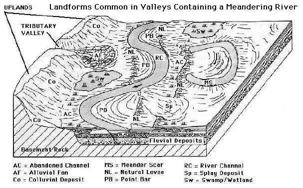
A meandering river with related sediments.
We can identify the environment based on the rock sequences we see in outcrop and we'll have a pretty good idea of what we can expect in areas the rocks are not visible. This is a model. Sure, our models are being revised and supplemented every day, but at least we have them. If you were to traverse the country today on foot, what would you see? You'd see different types of sediment that change depending upon the environment you find yourself in. You would pass through braided stream valleys, deserts, mountains, lakes, volcanoes, prairies, alluvial fans, and so on, until you have passed through a patchwork of sediments and depositional environments that may one day be buried, lithified, uplifted, eroded, and on display for the next generation of geologists. During this, you see life everywhere. It is continuing today as it no doubt did in the past (we have the fossils to suggest this), with hardly a care that sediment is being deposited and rocks are being eroded or that Faith thinks it's pure fancy. We hardly notice it happening today except during catastrophes, or if we look for it. The fact that you can't or won't understand what the rocks are telling you, really makes no difference at all. All that matters is that geology can back up any assertion with real life evidence and draw reasonable and valid conclusions from them. We are also completely aware that the next geologist can force us to change them should they discover something new and compelling. What can Creationism give us that is useful? If you want to learn what geologists today actually believe, then a good book to pick up is Prothero's "Interpreting the Stratigraphic Record." It's a second year college textbook. Another good one to pick up would be a book on historical Geology.
|
||||||||||||||||||||||||||||||||||||||||||||||||||||||||
|
roxrkool Member (Idle past 1017 days) Posts: 1497 From: Nevada Joined: |
I would like to reply to your posts, but it will take me a bit. I am back to work now (vacation was way too short) and I have to keep up on my running if I'm going to make 500 miles by the end of this year.
But I will try to hit some main points: 1. We know the sand is being deposited because it exists as a concentration of sand. As long as sand is being picked up by the wind and dropped on the dunes, it is being deposited. 2. Not sure what the source of the sand is as I have not had time to look it up. All I know is that if comes from the Northeastern part of Africa and is being transported by winds towards the Southwest. 3. The Sahara may or may not become rock in the future. It really just depends on whether it gets preserved. All the sand could completely blow away before it ever gets buried enough to lithify. Parts of the desert to the south have apparently been vegetated, and this would serve to improve its chances of preservation. The deeper and thicker the dune sedimentation, the better the chance of partial or total preservation. Sand dunes will not become a rock pancake, unless you mean "stratigraphic horizon." They will retain their internal wind-blown, cross-bedded structure, and extend only as far as what has been deposited. If the sea were to come into contact with the dunes as they exist right now, the sand would be re-worked where the water came into contact with the sand and all internal cross-bedding structure would get wiped out and the surface "flattened" by the action of the waves. The upper-most part of the dune would become beach sands first, but perhaps the dunes are 200 feet deep? If so, the deeper portions of the dunes would not be affected by the rising sea and therefore not reworked, but preserved and eventually overlain by beach sands, shale, or carbonate rocks. As the sea continues to rise, the water will deepen, and more and more marine sediment will be deposit atop the dunes. And when the sea retreats, its own wave action will eventually erode its way back through the most recently deposited marine sediments.But because the marine seds reached a depth of 500 feet, not all the marine seds will be eroded away. At that point, you have encroachment of continental sedimentation (maybe the sand dunes) atop the marine sediments. And voila! A stack of sedimentary layers. The waters have fallen and risen during the last few thousand years, so we know and can SEE that this is not impossible. 4. We see deposition today, so I'm not sure why you think it's impossible. It's all around you. The mountains are being eroded and the valleys are being filled. Talus piles are depositing, rivers are eroding banks and depositing sand bars, the ocean is precipitating carbonate, depositing muds (shale), and eroding beaches. 5. In the Southwest near Zion, all those lithified dunes are currently breaking down into sand, which is being re-worked into new sand dunes. The sand for the dunes could have come from anywhere. Beach sands, other dunes, mountains, lakes, and so on. So yes. The sand could have come from the ocean. Edited by roxrkool, : Bad grammar and poor writing.
|
||||||||||||||||||||||||||||||||||||||||||||||||||||||||
|
roxrkool Member (Idle past 1017 days) Posts: 1497 From: Nevada Joined:
|
Rox just wrote a post I see in which one of her comments is that if the ocean encroached on the sand it would destroy the shape of the grains, so that leaves a totally dry method of forming the sand into a flat rock pancake that stretches for thousands of square miles across the Southwest. Let's see how you explain that.
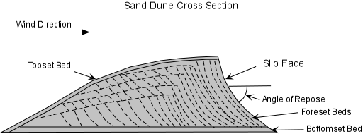
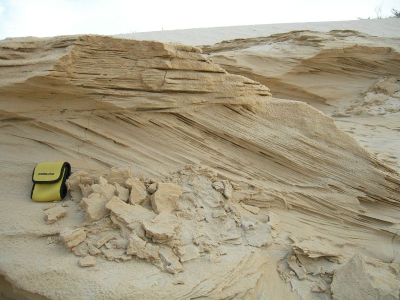
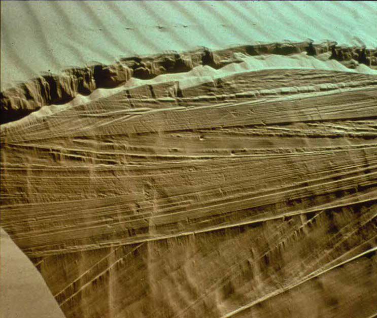
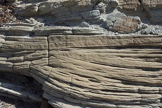
No. Absolutely not. The sea would not "destroy the shape of the grains." The action of the waves would destroy the internal CROSS-BEDDED structure of the sand dunes (assuming the dunes were unconsolidated sand) and re-work/re-deposit the dune sand particles. Although you've already been shown multiple times, cross-bedding looks like this:
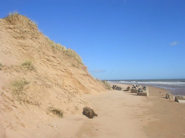
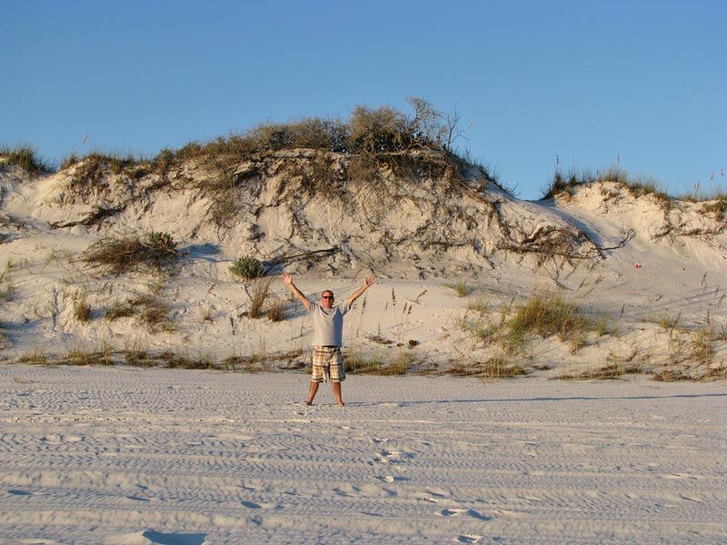
However, if the sand dunes were formed 200 feel deep, the transgressing sea may only affect the top 50 feet of the sand dune and not destroy anything below that. Essentially preserving the bottom 150 feet of the dune (including all it's internal cross-bedded structure). The top of the sand dune would be eroded flat because that is what water/wave action does. For example, flatness ...
.And what waves do to rocks...
|
||||||||||||||||||||||||||||||||||||||||||||||||||||||||
|
roxrkool Member (Idle past 1017 days) Posts: 1497 From: Nevada Joined:
|
The planet can be covered with gigantic areas of desert sands and the oceans with marine sediments, but getting them to stack up as the existing strata obviously did, uh uh.
That's where plate tectonics and eustasy come into play. Once you understand them, this question becomes moot.
|
||||||||||||||||||||||||||||||||||||||||||||||||||||||||
|
roxrkool Member (Idle past 1017 days) Posts: 1497 From: Nevada Joined:
|
Redwall limestone?
You're going to have to show this to me. There are units that correlate to other units in other states, but have been given different names due to lack of correlation at the time of mapping. It would not be impossible to be able to trace one single formation across the continent, but very difficult indeed. However, if you look at these formation in the sense of what formed across the continent at the same time, then you certainly could have a "Redwall Limestone" extend across thousands of miles. These are termed Chronostratigraphic units. A short excerpt:
quote: Another good quote (SOURCE):
quote:Some informative sites and movies to learn more about how geologists actually study the stratigraphic record: International Commission on Stratigraphy SEPMStrata UGA Stratigraphy Lab Apparently the ordering of the strata is quite predictable.
If you don't have a coherent model, you cannot predict anything.
problem is with the ideas about their sources which are pure abstract hypothesizing since apparently you have no actual existing source in mind for any of it. And again, don't you have a problem with explaining how all these different kinds of sand from different sources got together in one place and became an identifiable layer of sandstone?
No I don't have the actual source of the sand because I have not done any research on it. If I did, I would provide it. However, when it comes to clastic units, geologists want to know the source of the material and will do the research required to provide an answer. By performing chemical analyses on the mineral grains, particularly igneous-derived minerals, clays, etc., we can determine very specific element ratios, a fingerprint, that can be traced back to the source rocks if they still exist someplace in the stratigraphic record. This is common practice. All the different sources did not come together and form a homogenous mixture across a thousand miles. Different parts of the formation will have different colors, different chemistries, different mineral compositions, and so on. So if you collect a variety of samples from different locations, say 300 miles apart, and you perform various geological studies on them, you will very likely get different results. On something like the vast sand dunes. If you did so on marine-derived formations, you might be able to see homogeneous nature across a large areal extent. Continental rocks are formed from a variety of sources, but marine rocks can be fairly uniform. For obvious reasons.
Or in my language, what to you is "the same point in time" is to me simply the same layer: they are identifiable as one layer despite the different sediments found composing it in different places.
Not quite. If you stand on a beach looking out into the ocean, the beach is depositing beach sands, further out, the ocean is depositing shale, further out, the same waters are depositing carbonate (the chemistry, water temperature, light condition, clastic input, etc. have changed), further out a reef, further out siliceous ooze, further out, diatoms are settling out. If you turn around and look at the land, you'll see dunes, swamps, lakes, alluvial fans, rivers, plains, and so on. ALL of these processes are in the process of depositing something AT THE SAME POINT IN TIME. Now turn back around and walk into the ocean. First you step on beach sands, then your feet sink into muds (that will form shale), then you'll sink into a soft carbonate mud full of tiny little fossils, and so on. So if you followed the Redwall Limestone, or any unit in the GC, far enough out, you would find yourself in a different rock type. Somewhere, the Redwall limestone might become shaley, or sandy, or cherty. All these rocks, sand, shale, carbonate are being deposited TODAY. There are contemporary analogs for many of the rocks we find in the geologic record.
And to my mind this interfingering of different sediments is VERY easy to explain if it was all deposited by Flood waters, NOT so easy to explain on your time model.
Then please do so. Explain how the flood precipitates carbonate, then switches to sand, then back to carbonate, then to shale, then to chert. In fact, no flood since Noah's time, apparently, have precipitated carbonate. If you have evidence to refute this, I'd say this is a good time to present it.
For one thing you always lack a source from which they are BEING deposited, you just have to make one up, in fact you have to make up a whole bunch of them when you have such different sediments.
I lack a source because I have not taken the time to properly research all these things. However, I have a PROCESS that adequately explains why my rocks are where they are, why they possess the chemistry they do, why they possess the internal structures, fabric, and textures that they do. I know why shale exists versus limestone versus conglomerate versus sandstone. Where are your explanations for all these things?
There is no such problem with the Flood, which simply carried whatever got scraped off the land mass and broken down in the water.
But you can't tell me why one rock forms in place of another. I can.
OK here you are giving the source as geology presents it. Seems to me these sources are awfully small scale and fragmented compared to the actual extent of the strata in existence.
I don't know how you could possibly make that conclusion as we are not discussing any particular formation. You are making a sweeping generalization about nothing. Mountains are a large source of sediment on the continents. And if they rise for millions of years, there is a continuous source of sediment. That sounds like an awful lot of sediment.
Way back there HBD (herebedragons) put up a few diagrams of layers that extend for huge distances across North America. Nothing you've said is going on in the world now even begins to approach the extent of those layers. But the Flood could easily account for them.
I didn't see that post so I cannot comment. But it's also possible these immense units are actually different formations that were deposited at the same time, but in different basins or along a continental shelf. The west and east coasts of North America are pretty darn extensive and they are all depositing sand, carbonate at the same time. Ten million years from now, they would be linked geologically.
|
||||||||||||||||||||||||||||||||||||||||||||||||||||||||
|
|
Do Nothing Button
Copyright 2001-2023 by EvC Forum, All Rights Reserved
![]() ™ Version 4.2
™ Version 4.2
Innovative software from Qwixotic © 2024