|

Understanding through Discussion |
|
|
Register | Sign In |
|
QuickSearch
Summations Only | Thread ▼ Details |
|
Thread Info
|
|
|
| Author | Topic: Why the Flood Never Happened | |||||||||||||||||||||||||||||||||||||||||||||
|
RAZD Member (Idle past 1436 days)  Posts: 20714 From: the other end of the sidewalk Joined: |
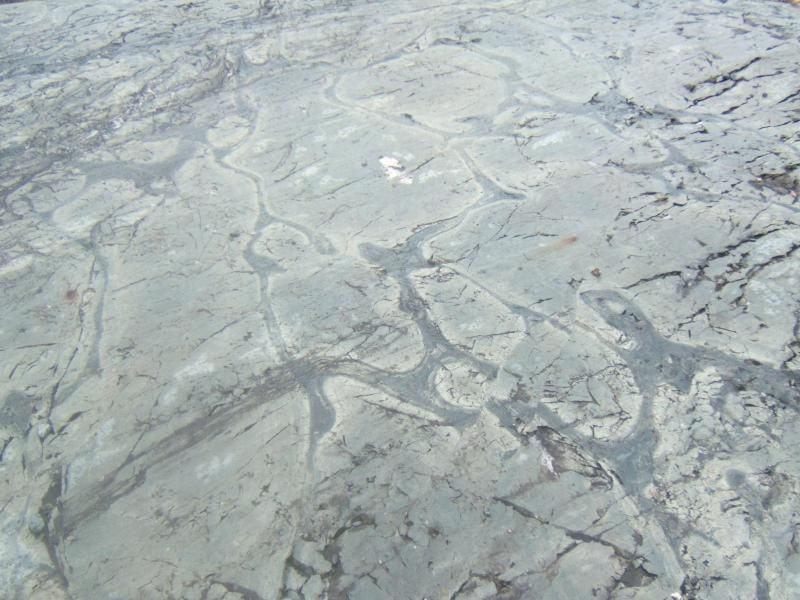
How does ooze lithify by the way, with nothing pressing on it from above? Several ways. See Limestone - Wikipedia and note that to cover all the different kinds of limestone, their compositions and formation process would fill a page.
Then later, like clockwork, hey it occurs to EVERY layer in the stack somehow or other, kind of like the Emperor's New Clothes I'd say, this DIFFERENT sediment, well, in this case it's just another calcareous ooze that's going to form a different limestone but it COULD have been sand dunes, ... Not quite. The fact that erosion has occurred is not because of clockwork or any plan, rather erosion occurred because the surface was exposed. For a long time. And yes the different layers of limestone have different compositions, hence the difference in colors and contents. (again see the wiki article Limestone - Wikipedia)
Of course it's ONLY in limestone that we see these "riverbeds," ... It's only in limestone that the evidence has been observed, not because they are limestone, but because that is what was on top when the erosion that is observed occurred.
And it shows up RIGHT ON TIME, too, never too early so that it mingles with the calcareous ooze, ... Ever heard of the argument from incredulity logical fallacy? What has happened is what has happened, it was not a predetermined sequence of events.
Except, of course, for the facts I've suggested above. ... Facts? I must have missed those in the flood of frantic fantasy.
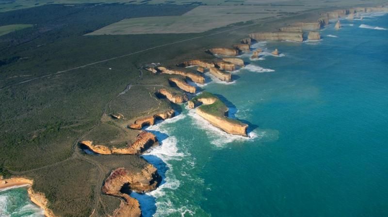
Now of course you CAN get a meandering stream between the layers of limestone, in the real world that is. Show me. Enjoyby our ability to understand Rebel American Zen Deist ... to learn ... to think ... to live ... to laugh ... to share. Join the effort to solve medical problems, AIDS/HIV, Cancer and more with Team EvC! (click)
|
|||||||||||||||||||||||||||||||||||||||||||||
|
RAZD Member (Idle past 1436 days) Posts: 20714 From: the other end of the sidewalk Joined: |
the same is said of islam.
but it doesn't matter who pulls the trigger, the gun still shoots. Enjoyby our ability to understand Rebel American Zen Deist ... to learn ... to think ... to live ... to laugh ... to share. Join the effort to solve medical problems, AIDS/HIV, Cancer and more with Team EvC! (click)
|
|||||||||||||||||||||||||||||||||||||||||||||
Faith  Suspended Member (Idle past 1475 days)  Posts: 35298 From: Nevada, USA Joined: |
The fact that erosion has occurred is not because of clockwork or any plan, rather erosion occurred because the surface was exposed. For a long time. I really can hardly believe the nuttiness of what you are saying. There IS no erosion between layers of the strata of the sort that would have occurred on the surface if exposed for a long time. That "riverbed" is NOT erosion, it's some kind of formation that occurs in limestone, no it is not merely incidental, it has something to do with its being limestone, and otherwise the lines between the layers are flat. Erosion does not flatten things. That is NONSENSE. Oh well. You keep accusing me of unreality but it's you that live there, not I.
|
|||||||||||||||||||||||||||||||||||||||||||||
|
Dr Adequate Member (Idle past 315 days)  Posts: 16113 Joined:
|
Perhaps this would be a good time to remind you that according to your own version of events, the top of the Kaibab Plateau was exposed by erosion.
It's no less flat than all the things you keep claiming can't be produced by erosion because they're too flat.
|
|||||||||||||||||||||||||||||||||||||||||||||
|
RAZD Member (Idle past 1436 days) Posts: 20714 From: the other end of the sidewalk Joined: |
I really can hardly believe the nuttiness of what you are saying. ... Cognitive dissonance.
... There IS no erosion between layers of the strata of the sort that would have occurred on the surface if exposed for a long time. ... Isn't it amazing how much your undereducated opinion is completely unable to alter reality.
quote: That's four surface levels that exhibit the effects of erosion in addition to the Great Unconformity.
... That "riverbed" is NOT erosion, it's some kind of formation that occurs in limestone, no it is not merely incidental, it has something to do with its being limestone, and otherwise the lines between the layers are flat. Erosion does not flatten things. That is NONSENSE. You have yet to show an example of such erosion that meticulously sticks to the boundary between two limestone layers, eroding down into one and not up into the other, layers you claim are level so there would be no grade to the flow ... This of course is because no such erosion pattern exists.
Oh well. You keep accusing me of unreality but it's you that live there, not I. Curiously you are the one denying objective empirical observable evidence, and unable to support your fantasy with evidence. Enjoy.by our ability to understand Rebel American Zen Deist ... to learn ... to think ... to live ... to laugh ... to share. Join the effort to solve medical problems, AIDS/HIV, Cancer and more with Team EvC! (click)
|
|||||||||||||||||||||||||||||||||||||||||||||
|
Coyote Member (Idle past 2137 days)  Posts: 6117 Joined:
|
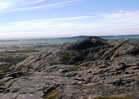
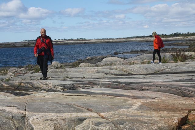
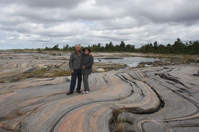
That "riverbed" is NOT erosion, it's some kind of formation that occurs in limestone, If it is a riverbed cut into limestone, it is erosion.Religious belief does not constitute scientific evidence, nor does it convey scientific knowledge. Belief gets in the way of learning--Robert A. Heinlein How can I possibly put a new idea into your heads, if I do not first remove your delusions?--Robert A. Heinlein It's not what we don't know that hurts, it's what we know that ain't so--Will Rogers If I am entitled to something, someone else is obliged to pay--Jerry Pournelle If a religion's teachings are true, then it should have nothing to fear from science...--dwise1
|
|||||||||||||||||||||||||||||||||||||||||||||
|
roxrkool Member (Idle past 1020 days)  Posts: 1497 From: Nevada Joined:
|
Rox just wrote a post I see in which one of her comments is that if the ocean encroached on the sand it would destroy the shape of the grains, so that leaves a totally dry method of forming the sand into a flat rock pancake that stretches for thousands of square miles across the Southwest. Let's see how you explain that.
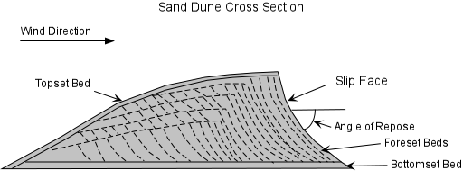
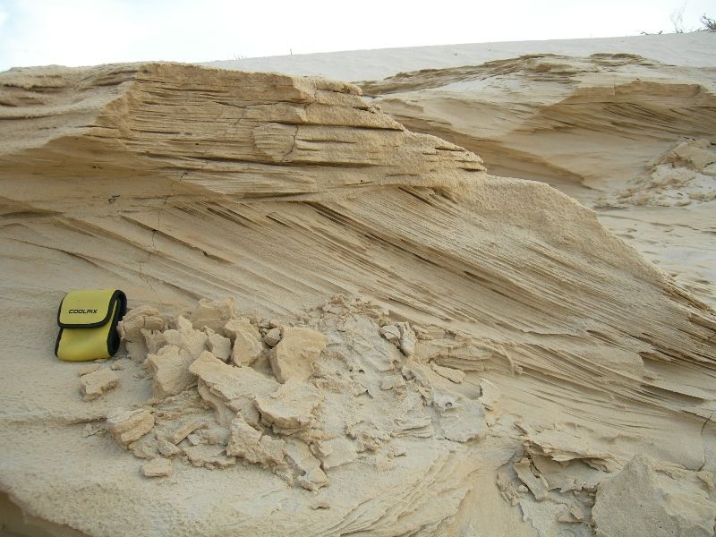
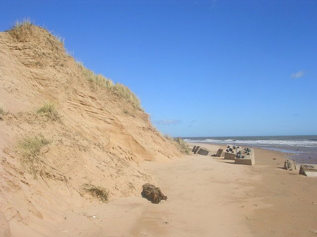
No. Absolutely not. The sea would not "destroy the shape of the grains." The action of the waves would destroy the internal CROSS-BEDDED structure of the sand dunes (assuming the dunes were unconsolidated sand) and re-work/re-deposit the dune sand particles. Although you've already been shown multiple times, cross-bedding looks like this:
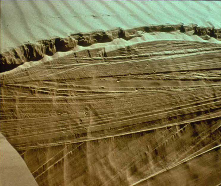
However, if the sand dunes were formed 200 feel deep, the transgressing sea may only affect the top 50 feet of the sand dune and not destroy anything below that. Essentially preserving the bottom 150 feet of the dune (including all it's internal cross-bedded structure). The top of the sand dune would be eroded flat because that is what water/wave action does. For example, flatness ...
.And what waves do to rocks...
|
|||||||||||||||||||||||||||||||||||||||||||||
|
roxrkool Member (Idle past 1020 days) Posts: 1497 From: Nevada Joined:
|
The planet can be covered with gigantic areas of desert sands and the oceans with marine sediments, but getting them to stack up as the existing strata obviously did, uh uh.
That's where plate tectonics and eustasy come into play. Once you understand them, this question becomes moot.
|
|||||||||||||||||||||||||||||||||||||||||||||
|
roxrkool Member (Idle past 1020 days) Posts: 1497 From: Nevada Joined:
|
Redwall limestone?
You're going to have to show this to me. There are units that correlate to other units in other states, but have been given different names due to lack of correlation at the time of mapping. It would not be impossible to be able to trace one single formation across the continent, but very difficult indeed. However, if you look at these formation in the sense of what formed across the continent at the same time, then you certainly could have a "Redwall Limestone" extend across thousands of miles. These are termed Chronostratigraphic units. A short excerpt:
quote: Another good quote (SOURCE):
quote:Some informative sites and movies to learn more about how geologists actually study the stratigraphic record: International Commission on Stratigraphy SEPMStrata UGA Stratigraphy Lab Apparently the ordering of the strata is quite predictable.
If you don't have a coherent model, you cannot predict anything.
problem is with the ideas about their sources which are pure abstract hypothesizing since apparently you have no actual existing source in mind for any of it. And again, don't you have a problem with explaining how all these different kinds of sand from different sources got together in one place and became an identifiable layer of sandstone?
No I don't have the actual source of the sand because I have not done any research on it. If I did, I would provide it. However, when it comes to clastic units, geologists want to know the source of the material and will do the research required to provide an answer. By performing chemical analyses on the mineral grains, particularly igneous-derived minerals, clays, etc., we can determine very specific element ratios, a fingerprint, that can be traced back to the source rocks if they still exist someplace in the stratigraphic record. This is common practice. All the different sources did not come together and form a homogenous mixture across a thousand miles. Different parts of the formation will have different colors, different chemistries, different mineral compositions, and so on. So if you collect a variety of samples from different locations, say 300 miles apart, and you perform various geological studies on them, you will very likely get different results. On something like the vast sand dunes. If you did so on marine-derived formations, you might be able to see homogeneous nature across a large areal extent. Continental rocks are formed from a variety of sources, but marine rocks can be fairly uniform. For obvious reasons.
Or in my language, what to you is "the same point in time" is to me simply the same layer: they are identifiable as one layer despite the different sediments found composing it in different places.
Not quite. If you stand on a beach looking out into the ocean, the beach is depositing beach sands, further out, the ocean is depositing shale, further out, the same waters are depositing carbonate (the chemistry, water temperature, light condition, clastic input, etc. have changed), further out a reef, further out siliceous ooze, further out, diatoms are settling out. If you turn around and look at the land, you'll see dunes, swamps, lakes, alluvial fans, rivers, plains, and so on. ALL of these processes are in the process of depositing something AT THE SAME POINT IN TIME. Now turn back around and walk into the ocean. First you step on beach sands, then your feet sink into muds (that will form shale), then you'll sink into a soft carbonate mud full of tiny little fossils, and so on. So if you followed the Redwall Limestone, or any unit in the GC, far enough out, you would find yourself in a different rock type. Somewhere, the Redwall limestone might become shaley, or sandy, or cherty. All these rocks, sand, shale, carbonate are being deposited TODAY. There are contemporary analogs for many of the rocks we find in the geologic record.
And to my mind this interfingering of different sediments is VERY easy to explain if it was all deposited by Flood waters, NOT so easy to explain on your time model.
Then please do so. Explain how the flood precipitates carbonate, then switches to sand, then back to carbonate, then to shale, then to chert. In fact, no flood since Noah's time, apparently, have precipitated carbonate. If you have evidence to refute this, I'd say this is a good time to present it.
For one thing you always lack a source from which they are BEING deposited, you just have to make one up, in fact you have to make up a whole bunch of them when you have such different sediments.
I lack a source because I have not taken the time to properly research all these things. However, I have a PROCESS that adequately explains why my rocks are where they are, why they possess the chemistry they do, why they possess the internal structures, fabric, and textures that they do. I know why shale exists versus limestone versus conglomerate versus sandstone. Where are your explanations for all these things?
There is no such problem with the Flood, which simply carried whatever got scraped off the land mass and broken down in the water.
But you can't tell me why one rock forms in place of another. I can.
OK here you are giving the source as geology presents it. Seems to me these sources are awfully small scale and fragmented compared to the actual extent of the strata in existence.
I don't know how you could possibly make that conclusion as we are not discussing any particular formation. You are making a sweeping generalization about nothing. Mountains are a large source of sediment on the continents. And if they rise for millions of years, there is a continuous source of sediment. That sounds like an awful lot of sediment.
Way back there HBD (herebedragons) put up a few diagrams of layers that extend for huge distances across North America. Nothing you've said is going on in the world now even begins to approach the extent of those layers. But the Flood could easily account for them.
I didn't see that post so I cannot comment. But it's also possible these immense units are actually different formations that were deposited at the same time, but in different basins or along a continental shelf. The west and east coasts of North America are pretty darn extensive and they are all depositing sand, carbonate at the same time. Ten million years from now, they would be linked geologically.
|
|||||||||||||||||||||||||||||||||||||||||||||
|
roxrkool Member (Idle past 1020 days) Posts: 1497 From: Nevada Joined:
|
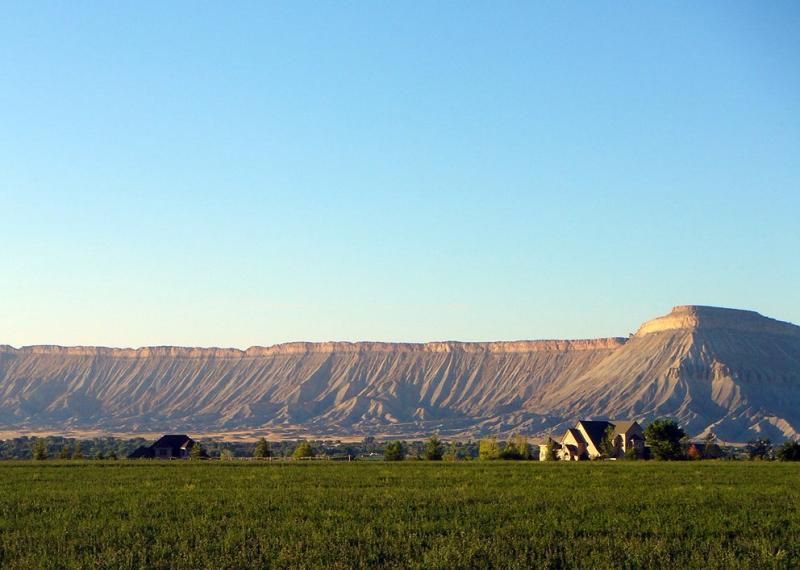
Erosion does not flatten things. That is NONSENSE.
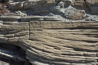
Of course it does. Rivers carve when base level is below the elevation of the water system/body. Rivers, streams, creeks, will carve the mountains and hills; but once that river/stream/creek hits the flats, it starts meandering and depositing its suspended load. Where there is no water system or body, then the weather (through physical and chemical processes), wind, and glaciers will erode the rocks, and these elements affect the highest points more than the lowest points. No different that the process of rounding quartz grains. Just how flat can rocks gets:
That's pretty damn flat and that's due to erosion.
|
|||||||||||||||||||||||||||||||||||||||||||||
|
RAZD Member (Idle past 1436 days) Posts: 20714 From: the other end of the sidewalk Joined: |
Way back there HBD (herebedragons) put up a few diagrams of layers that extend for huge distances across North America. Nothing you've said is going on in the world now even begins to approach the extent of those layers. But the Flood could easily account for them.
I didn't see that post so I cannot comment. But it's also possible these immense units are actually different formations that were deposited at the same time, but in different basins or along a continental shelf. The west and east coasts of North America are pretty darn extensive and they are all depositing sand, carbonate at the same time. Ten million years from now, they would be linked geologically. Message 448 What the maps show is deposits of the same age, not necessarily the same rock formation as Faith has misinterpreted it. Enjoy.by our ability to understand Rebel American Zen Deist ... to learn ... to think ... to live ... to laugh ... to share. Join the effort to solve medical problems, AIDS/HIV, Cancer and more with Team EvC! (click)
|
|||||||||||||||||||||||||||||||||||||||||||||
|
Percy Member  Posts: 22508 From: New Hampshire Joined: Member Rating: 5.4 |
Faith writes: I see I was wrong about the shape of riverbeds, so thanks for that. Nevertheless there is something really strange about this "riverbed" being filled with limestone instead of pebbles and the usual river bottom debris. This is the second time you've said this. Maybe someone addresses this later on, but anyway... Fast moving streams will have pebbles and rocky bottoms. A mountain brook is the most obvious example. Slow moving streams are incapable of moving pebbles. Their riverbeds will accumulate muck whose makeup is a function of the sediment carried by the stream, which is in turn a function of run-off upstream and the material in the landscape the river flows through. There should be a few pebbles and rocks in the sediments of the streambed that fall in from the riverbanks over time, but the vast majority of the bottom of slow moving streams should be a fine muck. Mountain brooks with their pebbly, rocky bottoms will never be preserved in the stratographic record because they exist in regions of net erosion. Only low lying streams in flat landscapes of net deposition will be preserved. --Percy
|
|||||||||||||||||||||||||||||||||||||||||||||
|
RAZD Member (Idle past 1436 days) Posts: 20714 From: the other end of the sidewalk Joined: |
Slow moving streams are incapable of moving pebbles. Their riverbeds will accumulate muck whose makeup is a function of the sediment carried by the stream, which is in turn a function of run-off upstream and the material in the landscape the river flows through. There should be a few pebbles and rocks in the sediments of the streambed that fall in from the riverbanks over time, but the vast majority of the bottom of slow moving streams should be a fine muck. And when spring floods occur, the water over the flood plain will be slowing down and depositing fine material as well. This is why flood plains are such good places for agricultural use -- they have good soil because of this process. The larger stones will be deposited near the baseline of the river where it exits the erosion area (mountains) in an alluvial fan. Finer sediments get carried further. One need only look at the muck deposited in and around buildings during floods to see that this consists of fine deposits rather than gravels and sand.
Floating organic debris is also carried by flood waters to the flood plains.  Edited by RAZD, : .by our ability to understand Rebel American Zen Deist ... to learn ... to think ... to live ... to laugh ... to share. Join the effort to solve medical problems, AIDS/HIV, Cancer and more with Team EvC! (click)
|
|||||||||||||||||||||||||||||||||||||||||||||
|
herebedragons Member (Idle past 888 days)  Posts: 1517 From: Michigan Joined:
|
What the maps show is deposits of the same age, not necessarily the same rock formation Exactly. Although more specifically they are maps of sedimentary rocks of the same geological age. They may even be exclusively marine deposits, but I am not sure about that. He does infer that the marked areas are seas. Since Faith has an issue with deep geological time, I tried to point out to her that there is no need to assign any time frame to the geological units to arrive at this pattern. So fine, assign ages based on the flood time frame. I even found this image that does just that
So with that, any objection to vast ages is irrelevant, because the relative order of the strata is determined independently from the age of the layers. Now the critical challenge is to explain how a single flood event could have laid down these layers with such high consilience that the strata are formed in this same relative order throughout the world with no mixing of the layers. Another thing Faith objects to is missing layers, but the fact is they are only missing from a local, which is very much problematic for a single flood event. Those maps show the layers do exist, but are distributed in a particular way. A flood mechanism needs to not only explain the relative order of the layers but also the pattern that the individual layers assume. To me that's really the main issue: how could a single flood have deposited all these layers??? That's the question a floodist needs to answer. But of course, there is no way to get that across to her. Now, did the great flood carve the canyon itself? I think that is a separate issue, one you brought up at If Caused By Flood Drainage Why is the Grand Canyon Where It IS?. HBDWhoever calls me ignorant shares my own opinion. Sorrowfully and tacitly I recognize my ignorance, when I consider how much I lack of what my mind in its craving for knowledge is sighing for. But until the end of the present exile has come and terminated this our imperfection by which "we know in part," I console myself with the consideration that this belongs to our common nature. - Francesco Petrarca "Nothing is easier than to persuade people who want to be persuaded and already believe." - another Petrarca gem.
|
|||||||||||||||||||||||||||||||||||||||||||||
|
herebedragons Member (Idle past 888 days) Posts: 1517 From: Michigan Joined:
|
Floating organic debris is also carried by flood waters to the flood plains. Do you consider a car to be "floating organic debris"?  HBDWhoever calls me ignorant shares my own opinion. Sorrowfully and tacitly I recognize my ignorance, when I consider how much I lack of what my mind in its craving for knowledge is sighing for. But until the end of the present exile has come and terminated this our imperfection by which "we know in part," I console myself with the consideration that this belongs to our common nature. - Francesco Petrarca "Nothing is easier than to persuade people who want to be persuaded and already believe." - another Petrarca gem.
|
|||||||||||||||||||||||||||||||||||||||||||||
|
|
Do Nothing Button
Copyright 2001-2023 by EvC Forum, All Rights Reserved
![]() ™ Version 4.2
™ Version 4.2
Innovative software from Qwixotic © 2024


 (1)
(1)