|

Understanding through Discussion |
|
|
Register | Sign In |
|
QuickSearch
| Thread ▼ Details |
|
Suspended Member (Idle past 1473 days)  Posts: 35298 From: Nevada, USA Joined: |
|
Thread Info
|
|
|
| Author | Topic: Evidence that the Great Unconformity did not Form Before the Strata above it | ||||||||||||||||||||||||||||||||||||||||
|
edge Member (Idle past 1735 days)  Posts: 4696 From: Colorado, USA Joined:
|
You're asking HBD and Edge how the gravel from the Archean layers became suspended in layers of the Tapeats. If they haven't stated it explicitly already, it occurred by the same familiar processes that create many sedimentary layers. It was weathered and eroded from the higher elevations of the Archean and carried there by water and gravity.
I think that, according to Faith, those sediment should be flat lying, so that boulders and gravel would not move away from their source by means of gravity or flowing water. However, logic tells us this is wrong. It sounds pretty basic, but as we go further out into the sea or lake, the water gets deeper. So, there must be a slope. On the other hand, if they were emplaced by shearing, the had to have moved along a plane. It is hard to see how that motion would be away from the basement if the sense of tectonic movement was upward. As to what Faith means by 'intrusion', I think she means tectonically transported to its current position. That would, as you have noted, imply a fault of some kind. And, of course, faults are almost always noticeable.
|
||||||||||||||||||||||||||||||||||||||||
|
ThinAirDesigns Member (Idle past 2402 days) Posts: 564 Joined:
|
edge writes: It sounds pretty basic, but as we go further out into the sea or lake, the water gets deeper. So, there must be a slope. BINGO!!! That's why I've been suggesting she find a lake or pond and merely step in or even reach in at the edge and feel all the gooey sediments. Since the lake is deeper in the center, there you have your sloped sediment evidence first hand. I don't know anything of Faith's situation but considering her comment about her sight, perhaps she is rather shut in and simply can't get out to see the real world and how her positions don't fit with what's out there. While having sympathy for such a plight, I would echo the comments of HDB where it was suggested she take a softer stance if she can't see or get out and about. She reminds me so much of George M Price and it isn't funny. JB
|
||||||||||||||||||||||||||||||||||||||||
|
edge Member (Idle past 1735 days) Posts: 4696 From: Colorado, USA Joined:
|
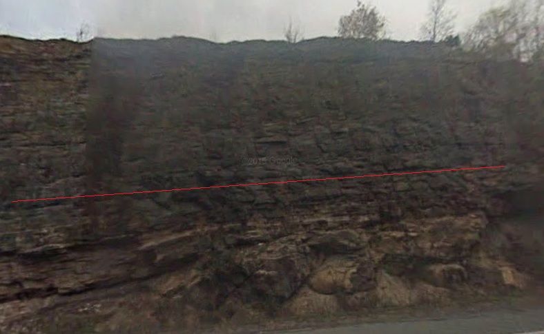
Of course it would be much better to be there, but I placed blue lines slightly to the right of every outline of a blasting hole that I could make out:
If I didn't say it before, this is a great catch. The reason for close spacing on the blast-holes is so that artificial fractures can propagate from hole to hole. If they don't do that, natural fractures will dictate how the rock breaks. For some reason several drill holes look like they were cut off short.
Although Google Street View is low resolution, it does allow you to view this feature from further to the left and right, and it appears possible that the bump upward of the red line in the right hand third of the image is misdrawn. It should perhaps remain straight at that point. But again, it would be better to be there.
I was looking at the same thing for a while. I usually go with what the guy who was there says, but, in this case, I think you are right.
But there's a more fundamental question. The rock face is the result of dynamite blasting. Why should how the rock face looks after being blasted indicate anything about tectonic forces and movements? This seems like just another one of those absurd ideas that you insist upon when you want to stop discussing something else.
As indicated above, there are natural fractures in the rock. Sometimes, actually seeing them is a function of scale. I've been on some fairly large faults that were hard to see unless you were across the valley. After that, you could go up to the fault planes and see where the brecciation and shearing make sense. But with all of the noise from other fractures it was hard to put a finger on what was actually happening. If you can filter out those patterns, you can start to see the meaningful stuff.
|
||||||||||||||||||||||||||||||||||||||||
|
ThinAirDesigns Member (Idle past 2402 days) Posts: 564 Joined: |
edge writes: For some reason several drill holes look like they were cut off short. I think you'll find that the drilling / blasting was done in two cuts (see line below) and that none of the drill holes go from top to bottom.
It's a bit hard to see (low res Street View), but that is a common method of excavation and you can see the offsets in the holes. JB
|
||||||||||||||||||||||||||||||||||||||||
|
Admin Director  Posts: 13042 From: EvC Forum Joined: Member Rating: 2.3 |
ThinAirDesigns writes: It's a bit hard to see (low res Street View), but that is a common method of excavation and you can see the offsets in the holes. We need Google to drive all around the country with a high-res camera so they can create Google Road Cut.  I see the offsets. Since it's visible in this image I'll comment on something I noticed earlier: the underlying gneiss in the bottom right-half of the image doesn't look like it was blasted at all. It sticks out about around 4 or 5 feet further than the rest of the rock face. Odd that they didn't just uniformly drill blasting holes to the same depth. I wonder if some sequence of charges failed to go off, and then they just left the relatively small amount of rock that wasn't blasted for the steam shovels, bulldozers and jackhammers to take care of.
|
||||||||||||||||||||||||||||||||||||||||
|
edge Member (Idle past 1735 days) Posts: 4696 From: Colorado, USA Joined: |
I see the offsets. Since it's visible in this image I'll comment on something I noticed earlier: the underlying gneiss in the bottom right-half of the image doesn't look like it was blasted at all. It sticks out about around 4 or 5 feet further than the rest of the rock face. Odd that they didn't just uniformly drill blasting holes to the same depth. I wonder if some sequence of charges failed to go off, and then they just left the relatively small amount of rock that wasn't blasted for the steam shovels, bulldozers and jackhammers to take care of.
Just guessing, but I think the gneiss was left as a bench and the surface we see has been ripped back to make room for the roadway. In the upper parts of the cut, they apparently wanted to make a smooth cut without unstable blocks that could fall. They have a lot better control over the slopes that way, too. For the gneiss, they didn't worry about that so much.
|
||||||||||||||||||||||||||||||||||||||||
|
Tangle Member  Posts: 9514 From: UK Joined: Member Rating: 4.8
|
I was out walking along our coast today (I live near to the White Cliffs on the English South Coast) and saw this (use the magnifier):
I'm no geologist, but that looks like a dome of chalk - ie layers of chalk not set down horizontally with layers above following the contour. It also appears to have an insert of a different rock. (The chalk is brown at this location because the beach and an artificial groin protects the cliff from the normal erosion seen on the cliff at the point at the far end of the picture.)Je suis Charlie. Je suis Ahmed. Je suis Juif. Life, don't talk to me about life - Marvin the Paranoid Android "Science adjusts it's views based on what's observed.Faith is the denial of observation so that Belief can be preserved." - Tim Minchin, in his beat poem, Storm.
|
||||||||||||||||||||||||||||||||||||||||
|
edge Member (Idle past 1735 days) Posts: 4696 From: Colorado, USA Joined: |
I'm no geologist, but that looks like a dome of chalk - ie layers of chalk not set down horizontally with layers above following the contour. It also appears to have an insert of a different rock.
Possibly. It almost looks like some kind of paleotopography. (The chalk is brown at this location because the beach and an artificial groin protects the cliff from the normal erosion seen on the cliff at the point at the far end of the picture.) Note the top layer has a pronounced vertical fracture pattern. It looks like it could also be some kind of soil development in the chalk. I'm thinking about traveling over there this summer sometime. The White Cliffs would be a site to see.
|
||||||||||||||||||||||||||||||||||||||||
|
Tangle Member Posts: 9514 From: UK Joined: Member Rating: 4.8 |
Pop by and I'll show you the rocks
Je suis Charlie. Je suis Ahmed. Je suis Juif. Life, don't talk to me about life - Marvin the Paranoid Android "Science adjusts it's views based on what's observed.Faith is the denial of observation so that Belief can be preserved." - Tim Minchin, in his beat poem, Storm.
|
||||||||||||||||||||||||||||||||||||||||
|
JonF Member (Idle past 197 days) Posts: 6174 Joined: |
I placed blue lines Er... They seem to have a tinge of yellow. Maybe it's just me.
|
||||||||||||||||||||||||||||||||||||||||
Faith  Suspended Member (Idle past 1473 days) Posts: 35298 From: Nevada, USA Joined: |
Anyway, how did this drag cause gravel to deposit out away from the basement along bedding planes? Yes, how did they get out there, where presumably before the sand was deposited they would have been hanging in space. Mere deposition shouldn't move them, so what moved them?
So, rather than being at the surface and saturated with water, you want to have the Tapeats buried under two miles of sediment and still be a soft sediment. That is your scenario, remember: all tectonism occurred after all the rocks were deposited. That is right, it's what I've been saying all along but it sounds like you just discovered it and now you're incredulous. Yes, the entire stack according to my scenario would have been deposited during the Flood, and to a greater depth than two miles I think, ALL of it of course saturated with water, all of it. By the time the upper layers were deposited the lower ones should have been thoroughly compacted into layers, so that they are pretty stable when the Flood recedes. The upper layers would be less stable of course, which is why I think they eroded away so drastically over the GC and to a lesser extent the Grand Staircase.
And you still show no evidence for 'intrusion'. Same evidence I started with: the draped sandstone which I still believe wouldn't just deposit in drapes but had to be pushed into that form, though you dispute that. AND what might be drag folds, though you dispute that too. That's my evidence, just needs some experimental work on it. If I'm right, though, it's good evidence.
How about some physical evidence? It seems that you are doing a whole lot of 'guessing' here. How about a fault? Maybe some offset beds or dikes? That would be nice, have any spare ones lying around?
The real problem for you comes when one tries to show the sense of motion along these shear plane that would move the gravel out into an apron-type of arrangement. I have a harder time understanding how they could have moved away from the mother-ship rock as it were, onto the Tapeats bedding planes before there was any sand there. That's a bigger problem, it seems to me, and that one is YOUR problem
Maybe you could draw in the shear planes and show the sense of motion along them that gives rise to these gravels. In the meantime, debris shedding from a topographic high explains things pretty well. Into the air? They just hover there at a distance from the main rock until the sand starts depositing and providing bedding planes for them to lie on? Edited by Faith, : No reason given.
|
||||||||||||||||||||||||||||||||||||||||
|
Faith Suspended Member (Idle past 1473 days) Posts: 35298 From: Nevada, USA Joined: |
Just out of sheer love of futility and having to deal with frustratingly misaimed arguments and objections, here's another attempt to get it all said, which may or may not be complete.
Edge has been making noises about there being no real distinction between a newly deposited layer and a layer that’s already formed but soft enough to deform, but it is precisely this distinction which determines whether the Potsdam Sandstone strata above the gneiss in the road cut picture were originally deposited on the gneiss in the highly irregular form we see it now, so that the lowest layers of the sandstone would have originally deposited on the incline of the depression of the gneiss on the left; as versus what it looks like to me, that those lowest layers sagged into that low place on the left after the whole stack had been there long enough to hold their shape as layers, while still soft enough to deform and sag into a depression that occurred during some kind of disturbance, probably tectonic.
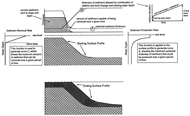
Based on the above, the distinction between strata newly deposited onto an incline and strata already formed but soft enough to sag onto the incline, is crucial to my argument. Edge is just waving it away. He says I lack a mechanism. What mechanism is needed besides deposition and tectonic disturbance? 1. The main argument against my interpretation has been that loose sediments, sand in this case, do deposit as layers along an incline so I should give up on the idea that they sagged in a soft-but-formed condition after having been deposited in the usual horizontal way as part of a stack of horizontally deposited strata. Some chide me for supposedly being unaware of common situations such as that mud collects along the slopes of lakes and ponds. However, the sludge you step in at the edge of a pond may follow the incline but not very likely at an evenly distributed depth as layers in the Stratigraphic Column do, and as the layers also do on the left bottom of the road cut picture. The only evidence that has been offered that a typical layer with such an even depth would occur at all from deposition on an incline is a diagram HBD put up way back there somewhere (Message 1032):
This is of course just hypothesis, not evidence, but even so the layer in the diagram thins out at the bottom which eliminates it as a model for the sagged layers in the road cut anyway. Funny that I’m supposed to be the one to do the experiment to test this for some reason, when I’m not the one claiming it happens; those who claim it happens should have the burden of proof that it does. I’ve decided, however, that I will try to set up the experiment in June when some guests will be here who can photograph the results. I don’t want the results to depend on what I say happened, I want to be able to demonstrate them. There was also some claim about snow as an analogy to the deposition of sand, too absurd to bother with in my opinion. In other words, there is so far NO evidence that strata form on inclines, certainly none of the strata seen in the Stratigraphic Column even if you can find a few layers in deltas and ponds and other bodies of water. Lots of assertions, no evidence. Some evidence for my interpretation:
2. Some want to attribute some or all of the deformations in the rock to the blasting done in cutting the rock back from the roadway.
Edited by Faith, : No reason given. Edited by Faith, : No reason given. Edited by Faith, : No reason given.
|
||||||||||||||||||||||||||||||||||||||||
|
Admin Director Posts: 13042 From: EvC Forum Joined: Member Rating: 2.3 |
Faith writes: ... That was me you're thinking of. You sent me an email asking, "Where are these supposed drill holes?" I responded with this image in which the blasting holes are very clear to help you find them in the image of the Potsdam Sandstone road cut:
I said, "Here’s an image with much more obvious blasting holes so that you know what you’re looking for." You asked, I told, I included an image. I don't understand how there could be any confusion about what blasting holes look like. And have you never driven through road cuts? That someone can send you a picture containing blasting holes clear as day and you can say, "I still don’t think I know what the blast holes are supposed to look like," indicates that the challenge in making things clear to you is even more difficult and profound than we've come to understand. Can you tell us what additional information would help you gain a clear idea of what blasting holes look like? If it helps, as near as I understand it, the holes are drilled in parallel, then the holes are filled with some kind of explosive charge like dynamite or (more recently according to Wikipedia) ANFO, then the charges are set off.
|
||||||||||||||||||||||||||||||||||||||||
|
Faith Suspended Member (Idle past 1473 days) Posts: 35298 From: Nevada, USA Joined: |
Actually the one you sent me via email IS clearer than the one we've been discussing. Little horizontal lines. Not at all clear on the road cut under discussion. But as I said, I don't think it matters since they are all above the deformed rock.
The picture you sent me, however, is not the one I was thinking of that has such a nice neat rock face in spite of being blasted. I guess I'll have to go look for it. ABE: Yes, here it is, in Message 1451:
He also marks a second picture to show the drill holes and I don't see them there either. Perhaps if a few were circled. Edited by Faith, : No reason given.
|
||||||||||||||||||||||||||||||||||||||||
|
ThinAirDesigns Member (Idle past 2402 days) Posts: 564 Joined: |
I think Faith is looking for end view holes rather than side view channels which are remnants of the drilled holes.
|
||||||||||||||||||||||||||||||||||||||||
|
|
Do Nothing Button
Copyright 2001-2023 by EvC Forum, All Rights Reserved
![]() ™ Version 4.2
™ Version 4.2
Innovative software from Qwixotic © 2024
 (1)
(1)