|

Understanding through Discussion |
|
|
Register | Sign In |
|
QuickSearch
| Thread ▼ Details |
|
Suspended Member (Idle past 1474 days)  Posts: 35298 From: Nevada, USA Joined: |
|
Thread Info
|
|
|
| Author | Topic: Motley Flood Thread (formerly Historical Science Mystification of Public) | |||||||||||||||||||||||||||||||||||||||||||||||||||||||
|
Percy Member  Posts: 22505 From: New Hampshire Joined: Member Rating: 5.4 |
Faith writes: Who said it's on your video? I know it's not and I didn't watch it because I know it's not because you don't understand one thing I'm saying. You quote nothing, so I have no idea what you're talking about. The message you're replying to mentions no video. The video I posted recently in a different message is this one:
Watching this video will take very little time. It is pre-positioned at the exact right point, and just watching for 30 seconds will illustrate clearly that flowing sheets of water don't split into streams.
Even though I can't really study the map I answered the basic idea. As I described my scenario for RAZD it should have been clear that the elevations NOW in place had nothing whatever to do with how the canyon formed IN MY SCENARIO. So how did they form? Are you saying the elevated regions weren't elevated when the Colorado River originally formed? Which is exactly what conventional geology says? If you're not saying this, then what are you saying?
This is tedious and boring since all you are doing is insisting that the standard establishment point of view is correct and if I don't accept it that means I son't understand it. Really tedious and boring. The fact of the matter is that issues are being raised about your scenario that you can't answer, a problem you face constantly. You employ various techniques when faced with this situation, all designed to distract from the topic. Just answer the question. The main Grand Canyon area is uplifted. Water can't flow uphill. How, exactly, did this happen in your scenario? --Percy
|
|||||||||||||||||||||||||||||||||||||||||||||||||||||||
|
Percy Member Posts: 22505 From: New Hampshire Joined: Member Rating: 5.4 |
edge writes: Check the video again. Can you point out for us where the sheets of water split into streams?
Perhaps Faith could show us where a flash flood forms meanders. That might be a start. In response to feedback Faith either adjusts her scenario or becomes very unspecific or even evasive and distracting, and her proposal becomes increasingly vague. Where she does become specific everything does have that Goldilocks quality of being just right, e.g.:
The violations of natural physical laws and known geologic principles just goes on and on. Why she can't see that what she's really invoking is magic, not science, is beyond me. --Percy
|
|||||||||||||||||||||||||||||||||||||||||||||||||||||||
|
Percy Member Posts: 22505 From: New Hampshire Joined: Member Rating: 5.4 |
Faith writes: Yes I "still believe" the Geological Column is over and done with and that whatever sedimentary layers are forming anywhere now have nothing to do with it. You're just making a bald declaration that is self-evidently wrong. Since the top of the geologic column is the Quarternary, and since we're currently in the Quarternary, and since the Quarternary extends on into the future, the sedimentary layers being deposited from this point in time forward are part of the Quarternary period. They're being deposited atop stratigraphic columns that fit into the framework of the geologic column. Nothing else is possible. You are dead wrong. Let us know if you see other possibilities.
Yes I believe it outlandishly absurd to think a layer of rock represents a time period. This is another bald declaration that is also self-evidently wrong. All sedimentation occurs during a time period, whether you believe it was hours or eons.
Boulders may fall on beaches all the time but that quartzite boulder buried in the Tapeats sandstone did not fall on any Tapeats beach. There was no Tapeats beach and the boulder was broken off by the tectonic motion at the end of the Flood that caused a massive sliding of rocks against each other. This is just another bald declaration that is again self-evidently wrong. There is no evidence of sliding between the Supergroup and the Tapeats at exposures in the Grand Canyon region, not even a tiny amount of sliding, let alone a massive amount. It wouldn't help you with the cubic miles of disappearing rock anyway, since turning rock into pebbles does not decrease volume. Even turning rock into dust doesn't decrease volume. In fact, given that dust and pebbles don't pack as tightly as solid rock, it would represent greater volume. The Shinumo hills boulder on a Tapeats beach is a typical example of what we see happen on beaches around the world that are lined with hills or mountains.
As for popular accounts of the historical sciences it's frustrated me from way back before I was a Chrsitian or a creationist that stories about evolution presented extraordinarily ancient times as flat out factual realities, especially when they imaginatively reconstructed the supposed living conditions of some extinct creature; and in those days I had no reason to disagree with any of it, it was just frustrating to be given such fiction in such a dogmatic way. NOW I suppose it's because I know it is all false that it particularly annoys me. The reality is that you still have no evidence driving your doubts about geology. You just have a bunch of Biblically driven ideas you made up that are magical rather than scientific. Why you don't just invoke God is beyond me. After all, you're already subordinating facts to whatever you think the Bible says.
Now, meaning for the last oh 25 years or so, on trips where I've seen those signs telling me this or that geological formation is so many millions of years old I laugh and roll my eyes. Well, as I keep telling you, if you're going to keep inserting yourself into the conversation then so will I. Congratulations on maintaining your ignorance for so long. --Percy
|
|||||||||||||||||||||||||||||||||||||||||||||||||||||||
|
Percy Member Posts: 22505 From: New Hampshire Joined: Member Rating: 5.4
|
I saw the video a number of years ago and thought the animation of incision and recession was a particularly helpful visualization, it's happening at Niagara Falls right now, but it struck me as an exceedingly unlikely origin for the Grand Canyon, so when it resurfaced in this thread I thought I'd do a little checking into how well this possibility has fared in the geological community. Don't bother reading this if it doesn't interest you. It's just something I've felt like doing for a while, and this was a good opportunity.
The geologist the video featured who advocated the incision and recession origin was John Douglass of Paradise Valley Community College. The idea was originally presented at a 2000 Symposium and was published with co-author Norman Meek as Lake-Overflow: An alternative hypothesis to explain Grand Canyon incision and development of the Colorado River. He hasn't published on the topic since, nor at all since 2010. The idea apparently originated with Eliot Blackwelder in his 1934 paper Origin of the Colorado River. Checking Google Scholar for references, the Douglass/Meek paper has been cited by 56 related articles. A number of papers were published on the topic, primarily based out of the University of Arizona and the Arizona Geological Survey. The idea seemed to evolve, coming to stress incision downstream from the canyon and not in the canyon itself. The most recent paper listed was published in 2010, and I guess after that enthusiasm waned. A 2012 article at Live Science (Grand Canyon Carved by Flood? Geologist Says No) seems to confirm this possibility:
quote: Dickinson's paper was published in 2013: Rejection of the lake spillover model for initial incision of the Grand Canyon, and discussion of alternatives. The reasons it cites for rejecting the idea were that the lake never achieved appreciable depth, the elevation isn't compatible with lake spillover, multiple river canyons are present, the timing of drainage reversal wasn't right, and a couple others. Not that a non-geologist's ideas on detailed research matter, but the reasons I never liked the incision idea were based simply on the geology of the canyon. The Colorado River passes through an uplifted region, something that could only happen if uplift and downcutting occurred gradually and simultaneously. Rapid incision requires that the river already be present. The Dickinson paper also mentions elevation concerns. The elevation problem seems like it should have been obvious in the Douglass/Meek paper, since Figure 2 positions the hypothesized lake adjacent to the Kaibab upwarp, and the lake water wouldn't have been able to flow uphill. The Kaibab uplift occurred around 6 MYA, and Dickinson says that even before the uplift that Hopi Lake (the lake of the Douglass/Meek paper) had insufficient elevation to feed water into the region. According to Wikipedia (Colorado River: Origin and Development) the region around the western Grand Canyon used to drain north, though they don't know to where. They do say that that the ancestral river system was land locked. Something had to have happened to connect this ancestral upper Colorado to the lower Colorado, and they do mention possible involvement of a breakout of a lake or river, but not rapid incision. Whenever and however the upper and lower Colorado joined, the formation of the part of the Grand Canyon that is now deepest and most spectacular in the Kaibab uplift was already well underway. Also, the Douglass/Meek paper postulates a lake in order to provide a prodigious water flow, but as the Colorado makes clear annually, no lake is required for a prodigious flow, though of course modern controls and draws upon the water have rendered the river much more tame than in the past. Also, the Grand Canyon is 18 miles wide at its widest point. This could only be due to a braided river spread across a plain that downcut into the plateau in at least two places and probably more, as is evident from the multiple plateaus situated in mid-canyon. Simultaneous incision by rapid flow in multiple braids seems most unlikely. I think the Dickinson paper is alluding to this issue when it mentions multiple river canyons. --Percy
|
|||||||||||||||||||||||||||||||||||||||||||||||||||||||
|
Percy Member Posts: 22505 From: New Hampshire Joined: Member Rating: 5.4 |
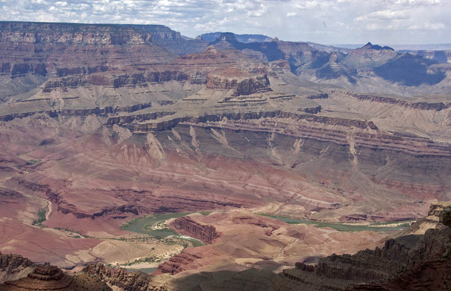
Faith writes: They'd have to roll at least nine miles to get to the river if the river ran through the middle of it, and if you look at that area of the canyon it's full of buttes and other mounds of eroding strata that would make it difficult for any rock falling off the outer wall to get anywhere near the river even if it was all downhill. You're thinking of this situation:
And you're wondering how grains, pebbles and rocks eroded from that canyon face way off in the far distance ever find their way to the Colorado River there in the foreground. First know that rain and wind and collisions with other debris and freeze/thaw cycles break these erosive products into smaller and smaller pieces. And realize that gravity always causes them to seek the lowest point. Water also seeks the lowest point, flowing continuously downward until it reaches a lake or sea. Flowing water carries sediments. Even relatively low energy water can carry small grains of sediment, and the higher the energy of the water the larger the sediments it can carry. When the Colorado rages in the spring it can carry 10 ton boulders. Now look in the lower left 20% of the image. See that stream flowing into the Colorado? It carries sediments. From exactly where we can't tell, but the canyon is full of streams and creeks, many that probably only flow seasonally, but that's how most sediment eventually reaches the Colorado. --Percy
|
|||||||||||||||||||||||||||||||||||||||||||||||||||||||
|
Percy Member Posts: 22505 From: New Hampshire Joined: Member Rating: 5.4 |
Faith writes: It is so wearying dealing with this constant refusal to grasp what I'm saying. What I'm saying is SO simple. A tsunami is a wall of water not a thin sheet running across a flat plain. And yet that's exactly what the video shows, a thin sheet of water running across a flat plain. You didn't watch the video, did you. You only have to watch about 30 seconds of it to clearly see that it shows a thin sheet of water running across a flat plain. Here's the video again, still positioned at the exact right spot:
Watch the video for 30 seconds. Click the "full screen" icon so you can see it clearly. Judging by the buildings and low structures it encounters, it's maybe 5 feet high.
Here's what I'm picturing again: By the time the water is at that stage in my scenario, which I thought I described pretty clearly so that any nonsense about a tsunami would be clearly inapplicable, the Flood is almost completely drained away. Anything like tsunami stage is long since past. I'm simply trying to picture the stages it would have gone through to supply just the right amount of water for it to meander as streams do across flat plains. I don't even care if it ever becomes a sheet, I'm just trying to picture the likely stages to get it to the meander stage and a thin sheet seemed like a likely stage, but it doesn't matter. So in other words, you're changing your story again. Maybe there was a thin sheet of water (and who knows how thick "thin" is), maybe there wasn't, it doesn't matter. What you need is for the flood waters to recede and become a slow flowing low energy stream capable of meanders that can still somehow erode a canyon a mile deep and 18 miles wide in only a few months, even though the water is far too low in energy to do any meaningful erosion or to carry away that huge volume of sediment. Good luck with that. You don't need science, you need magic.
The flat plateau is there after all the strata above have been washed away and now there's still some water running across it, a lot of it I'm figuring having already exited over the sides of the opening canyon. This isn't very clear or consistent. Why is water "running" across the plain now that the channel that will eventually become the canyon is present, and why would water running in a channel like the "opening canyon" be exiting over the sides? This all sounds like very energetic water. In your previous paragraph you were imagining water lazy enough to form meanders.
The Kaibab plateau is a large flat limestone area to the north of the canyon running east to west along it for some distance. The deepest and widest part of the Grand Canyon is located in the southernmost part of the Kaibab Plateau.
Meanders form on flat surfaces and Marble canyon is somewhere in that area. Marble Canyon, which is a pretty long stretch of the Colorado River just like the Grand Canyon, is not located in the Kaibab Plateau, but I believe it's pretty flat in that area, too.
After the water of the Flood has mostly disappeared there's still a stream there to form the meander. It is really not hard to account for these features in the Flood scenario. Again, water of low enough energy to form meanders cannot perform downcutting, not even in soil let alone rock.It couldn't even downcut into your impossible soft rock that miraculously turns to rock upon drying. By the way, since you believe the sedimentary rocks were wet and malleable after the flood and only became hard by drying, why is it that the rock beneath the Colorado is just as hard as the rock everywhere else in the canyon?
There is no point in making up conditions that would prevent it such as your tsunami scenario since there is no need for anything like that to be happening. You said a flat sheet of water, which is precisely what that video shows. The difference is that the Japan Tsunami of 2011 was real while everything you say is made up, such as flat sheets of water running across landscapes and turning into streams. You essentially conceded it was made up just a couple paragraphs ago when you said it didn't matter one way or the other.
The water drains away, a long crack is becoming a canyon... Now it's a crack? When are you going to get your story straight? What caused the crack?
...into which a lot of the water has flowed already,... How could there be a lot of water flowing when it is slow enough to create meanders?
...and cut it out to some width to the west,... What does "cut it out" mean? Do you mean eroded? If so, what happened to the crack?
...a thin sheet of water becomes thin streams that form a meander to the east that becomes a river that runs through the canyon. Now you're back to the thin sheet of water again? Is it necessary to your scenario or not? Make up your mind.
All I can do is imagine how it could have happened. If something doesn't work then something else will. In other words everything you say is made up, and when even you can't deny it anymore you'll change your story.
Incidentally on the south side the Kaibab limestone was washed away leaving the Coconino sandstone called the Coconino plateau. Kaibab limestone is the top layer throughout most of the Coconino Plateau.
Such broad expanses of sedimentary rock certainly suggest to me the washing effect of a lot of water. Sure, but was it a lot of water over a short or long period of time? Whatever your answer, how do you know?
So The Flood washed down to the Kaibab limestone on the north side and down to the Coconino on the south. Again, no. Kaibab Limestone is the top layer to the south, too.
And if Marble Canyon isn't strictly on the Kaibab Plateau,... It not only isn't strictly on the Kaibab Plateau, it isn't on the Kaibab Plateau at all.
...who cares,... Not you, certainly. Caring about facts has never been your strong point.
...for a meander to form there has to be a flat plain one way or another. There also has to be slow low energy water, but which unfortunately for your scenario is incapable of significant erosion. You've once again made it through an entire post without saying almost anything true. --Percy
|
|||||||||||||||||||||||||||||||||||||||||||||||||||||||
|
Percy Member Posts: 22505 From: New Hampshire Joined: Member Rating: 5.4 |
edge writes: As I might have said here earlier, it is my opinion that uplift does not create mountains ... erosion does that. This is kind of brief, so I'm going to see if I can fill in the blanks. For erosion to create mountains the region would need to be elevated by at least a couple thousand feet above sea level, then uneven erosion of the landscape would leave behind mountains. But it doesn't seem like uneven erosion of a region could create what we normally think of as mountains. It would create what we normally think of as erosive structures, like the buttes in the American southwest, not mountains. So I guess I don't get it. I think of mountains as strata thrust up and tilted and bent by tectonic forces such as colliding plates. --Percy
|
|||||||||||||||||||||||||||||||||||||||||||||||||||||||
|
Percy Member Posts: 22505 From: New Hampshire Joined: Member Rating: 5.4 |
Faith writes: I did watch the video finally, yes. I'd seen many like it before. If you've already seen many similar videos, why did I have to present a video for you to understand what I meant?
That is not a thin sheet of water, that is a battering ram of water that picks up and carries vehicles and boats and houses. A thin sheet would be a few inches at most. What you originally said back in Message 111 when I first posted the video was this:
Faith in Message 111 writes: ...a lot of water crossing a flat plateau and forming a stream that becomes a very wide meander... Later you begin employing the term "thin sheet", but you continued saying a lot of water was flowing. No one would think you meant water a few inches deep. You skipped a lot in my post. The key issues:
--Percy
|
|||||||||||||||||||||||||||||||||||||||||||||||||||||||
|
Percy Member Posts: 22505 From: New Hampshire Joined: Member Rating: 5.4 |
Faith writes: By the way is the Kaibab Uplift the same as the Kaibab Plateau? Kaibab uplift, upwarp, plateau, they're all referring to the same thing. Which one would be preferred depends upon context. When writing about the geological processes that created the region you would probably prefer uplift or upwarp. When writing about the region's geography you would probably call it a plateau.
I realized the plateau rises toward the canyon so I can't have a meander running across it. I have to rethink the meander... So the story's going to change again. What a surprise. --Percy
|
|||||||||||||||||||||||||||||||||||||||||||||||||||||||
|
Percy Member Posts: 22505 From: New Hampshire Joined: Member Rating: 5.4 |
Faith writes: Sorry for the phrase "lot of water" but honestly Percy for you to turn that into a tsunami when I was trying to get to a meander is major deceit. What we actually have here is major dishonesty. In the very message you're replying to I listed the issues you skipped, significantly that you trying to get meanders while still describing water with a great deal of energy. Here are the issues again:
--Percy
|
|||||||||||||||||||||||||||||||||||||||||||||||||||||||
|
Percy Member Posts: 22505 From: New Hampshire Joined: Member Rating: 5.4 |
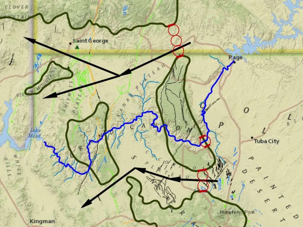
Faith writes: I've been trying to figure out exactly where the Kaibab uplift occurred... Two images have been presented giving a very good idea of where the Kaibab uplift is. You presented one, RAZD presented another, here they are:
Your image shows the Kaibab Plateau. RAZD's image shows the region of greatest elevation due to the Kaibab Uplift, which includes the Kaibab Plateau of your image but also extends a bit south into the Coconino Plateau. It's the darker green area that's almost dead center. Here's an elevation map of Arizona. You probably won't be able to see it, but in case you can the Kaibab Uplift is the dark brown area near the top of the map. You can even make out the Grand Canyon at the southern end of the uplift:
Tectonic upheaval occurs pushing a lot of rocks around at least three miles below the surface of the water at this point...So now we've got the whole stack being pushed up in this one area and cracks form in the upper layers. You've never explained how tectonic forces could push around some strata without affecting adjacent strata.
The tectonic movement coincides with the start of the draining of the Flood, maybe because of the sea floor dropping as some have suggested. Would it be unreasonable if we just want to see the evidence spelled out because your usual presentation makes bald assertions about things you couldn't possibly know about (if this sentence looks familiar its because it's basically the same sentence you wrote at the beginning of your second paragraph in Message 1).
The water level starts going down. But it's a pretty slow process, takes five months or so as I recall to completely drain away. Yeah, sounds like a really catastrophic receding of the waters capable of etching deep canyons.
As it starts draining the uppermost layers break up. Five months of draining of, let's say, five miles of water is a lowering of water level of about an inch and a half per minute. Does that really sound like enough to etch canyons to you?
Maybe they are mostly loose sediment at this point. Sure, maybe, maybe not. You have no idea and no evidence.
At some point the water starts moving laterally toward the deepening sea. Your scenario has the sea still covering the land to a height of over a mile above sea level (elevation around the Grand Canyon is in the neighborhood of 7500 feet), and water levels are lowering. How could the sea be deepening?
Strata start to be exposed but they are still not compacted enough to hold together very well so they keep breaking up and now start washing with the draining flood water toward the oceans. Lowering of the water level at a rate of 1.5 inches/minute couldn't carry away loose sand, let alone your compacted-but-not-too-compacted strata.
We're still mostly looking at an expanse of water everywhere though strata to the north in the Grand Staircase area are holding together better though breaking up into cliffs and that should be visible, but overall it's a lot of water still, it's just lower now and it's moving in various directions. Why do you think lowering water levels of 1.5 inches/minute would create much water flow? Imagine an above ground swimming pool with yourself standing in the middle. Someone drains the pool at the rate of 1.5 inches/minute. How much force of water flow do you think you're going to feel? What you need to happen is more like this compilation of catastrophic pool collapses:
But of course this is a lowering of water level of maybe 4 feet in 10 seconds, which is about 24 feet/minute, or 200 times faster than your scenario. --Percy
|
|||||||||||||||||||||||||||||||||||||||||||||||||||||||
|
Percy Member Posts: 22505 From: New Hampshire Joined: Member Rating: 5.4
|
Faith writes: But the fact remains that you've got a huge flat slab of rock covering a huge area where you think there used to be an ancient landscape with ancient forms of living things, and that is impossible. You continue to misunderstand this. The processes of Walther's Law that we usually discuss involving slow transgressions of seas onto land do not often preserve terrestrial landscapes. Rather they grind them up and separate the resulting sediments into sand, silt, mud and clay. The sequence of Tapeats Sandstone, Bright Angel Shale and Muav Limestone formed this way. We will never know what was on the land that the sea transgressed across. That landscape is gone, transformed into seascapes that did get preserved in the stratigraphic record. But terrestrial landscapes *can* be preserved. It just doesn't happen anywhere near as often as for marine strata. They tend to be associated with coastal, swamp, lagoon, lacustrine, river and stream environments. The Claron was a bunch of plains, lakes and streams, as was the Morrison Formation where dinosaur fossils are common. Walther's Law does apply to these terrestrial environments. Rather than the transgressing and regressing seas we usually discuss, on land it is changing river and stream courses and changing lake, swamp and lagoon boundaries that represent migrating depositional environments. And of course it is depositional environments where life can become buried and preserved, such as dinosaurs living in the surrounding landscape. Some dinosaurs undoubtedly spent time in the water. --Percy Edited by Percy, : Clarified first and last paragraph. Edge had already replied in Message 258 when I did this, and he quoted the original form of the first paragraph, which included the error where I misspoke and implied that Walther's Law doesn't occur on terrestrial landscapes.
|
|||||||||||||||||||||||||||||||||||||||||||||||||||||||
|
Percy Member Posts: 22505 From: New Hampshire Joined: Member Rating: 5.4 |
Faith writes:
What boulders are you talking about?
The ones that occur in the Colorado River beds downstream from the GC. Why would you assume the chunks of strata I attribute to the first stages of the receding Flood would be those boulders? What are you saying happened to those boulders? That every one eroded away? Every one was washed into the sea? What? In any case I have a sort of related question: If rocks form by drying, why are the rocks beneath the riverbed of the Grand Canyon just as hard as rocks elsewhere in the canyon?
I have no idea what form the broken up chunks of st rata ended up in after being washed through the canyon I'm sure you don't. The point is the sediments were probably too soft to form boulders at that stage. If a large chuck of broken off strata is not a boulder, what is it?
-- but most of that would have gone over the sides lower in the canyon, not down the river from the upper part of the canyon. Why do you assume boulders? But all of those rocks were deposited by the flood, not? Why are they so much harder than the rocks of the Grand Canyon such that they survived hundreds of miles of river transport? I do't know where you are getting this? The earliest broken up strata were probably just loose sediments. You probably wouldn't get boulders for a few years. Again raising the question of what large chucks of broken off strata are. Now you're changing your story and saying there were no large chucks of broken off strata, just loose sediments. What happened to your story of tectonic forces creating the Kaibab Uplift that in turn created strains that broke up the strata into chunks that the receding flood waters carried away. And if these chunks "would have gone over the sides lower in the canyon" then aren't they still there, just as Edge said earlier? And so don't you have to address the question of why these chucks, however big they are, are just as hard as all the other rock in the canyon?
But further, if the rocks of the GC were relatively soft compared to now, how did they get to be so hard just being exposed at the surface for the last 4 thousand years? As I understand it compaction alone can make a very hard rock, but I also think chemical lithification doesn't take anywhere near as long as is usually supposed. You state that "chemical lithification" doesn't take as long as we think, implying that these chucks that resulted from the breakup of strata above the Kaibab from the strains of the uplift were already hard, so why have you in the past described that they only broke so easily into chucks because they were still "wet and malleable". When you change a thread title you should include in the edit comment what you changed it from. There is now no record of the original title. --Percy
|
|||||||||||||||||||||||||||||||||||||||||||||||||||||||
|
Percy Member Posts: 22505 From: New Hampshire Joined: Member Rating: 5.4 |
Why "massive?"
OKay, fine. Moving a two-mile deep body of water off the continent isn't massive. Fine with me. But I thought we're talking about how the meander formed, and that would have happened long after the two miles of strata not just water) above that level had drained away, leaving the stream that became the meander. You have a stream flowing through a terrain so level that the stream flowed so slowly that it could form meanders. How did it also have enough energy to erode through a half mile of anything, whether it was loose sediments or your crazy "wet and malleable rock" or normal rock?
At some point the water got down to the volume where streams running across the plateau could form a meander. That's the point. It's not about the volume of water. It's about gradient and time to create meanders. What point are you making here? I'm just trying to show how the recedeing Flood could have reached a level where it could have formed the meander that actually exists. I've pictured the water reduced to that level already. By gradient Edge means the terrain was pretty level, i.e., there wasn't much gradient. That would create the time to create meanders. But you also need water with sufficient energy to quickly erode.
We're talking about a great volume of water gradually decreasing. It's silly to think it couldn't have decreased to the point of forming a meander, given a huge flat area which is where meanders commonly form. That isn't what we see in the real world. Well you might have seen it if you'd been around at the time of the Flood. Sheesh. Since you weren't around at the time of the Flood, and since there is no evidence for the Flood, you have no basis for this claim. As Edge points out, you are describing something we never see in the real world. The reason for that isn't that it's a rare one-time event but that it's not what happens when water rolls catastrophically across a landscape. The Missoula Floods are an example of that. Try finding a meander created by these massive floods.
And remember, you still don't have evidence of such a sheet flow in the first place. I don't have to have a sheet flow, but what is this supposed evidence I'm supposedly lacking? If you have to ask what the evidence is, obviously you have none. Edge is asking for the evidence that you demand magazine articles should include.
It figures it would decrease to a sheet before becoming separated streams, that's the only reason for including a sheet, it's the natural transitional form from a larger volume of water to the right amount and shape to make meanders. Except that we don't have sheet flow. And again, how do you know that? Things like flows of thin sheets of water don't magically come into existence on your say so. Acceptance of the idea of such a flow would be driven by evidence, of which you have none.
ABE: Overall I have the question why you keep saying my scenario lacks this or that evidence, the gravel, the turbulence, the back flooding and so on and so forth. Edge keeps saying that your scenario lacks evidence because nothing we see today lends any credence to the events you claim happened.
You are imagining the Flood being appreciably different from whatever you think formed the meander and I have no idea why. Rapidly flowing water capable of significant erosion cannot create meanders. There are meanders in the main canyon:
And there are more meanders downstream from the canyon:
So there are meanders in Marble Canyon, in the Grand Canyon, and downstream from the canyon, and they're all eroded significantly into the landscape, some a mile deep. A landscape cannot have two different gradients at the same time, one steep enough to create rapidly flowing water capable of deep deep erosion, and another gradient low enough to create slow flowing water capable of meanders.
Seems to me whatever you see now could just as well be explained by the scenario of water left running across a plateau after the Flood as by water from any other source. Many impossible things seem possible to you. Why do you think this possible?
Sheet flow isn't necessary so I can drop that but I still wonder what evidence you think would be there if it had occurred. /ABE So thin sheet flows are out again. For now. --Percy
|
|||||||||||||||||||||||||||||||||||||||||||||||||||||||
|
Percy Member Posts: 22505 From: New Hampshire Joined: Member Rating: 5.4
|
minnemooseus writes: Remember out favorite "Walther's Law" diagram:
The bottom left of this diagram illustrates the difference between lithostratigraphy and chronostratigraphy. As you go right to left, the lithostratigraphy (say, the sand unit) becomes progressively younger. And the top surface of the various sediments are the "landscape" of the time. It would probably also be useful to explicitly point out to Faith that by "landscape" you mean seascapes being created according to the principles of Walther's Law. These seascapes that become preserved in the stratigraphic record are not the landscapes that the sea transgressed across. Those landscapes are gone, ground away by active coastal waters into sand, silt, mud and clay. The constituent elements of the landscape are preserved as particles of sediment. For example, if the landscape was rich in some element like iron, then the marine sedimentary layers will include that element. Also, terrestrial life living near the coast can be washed into the sea, buried and preserved. Rivers can carry carcasses downstream and out to sea. So sandstone layers, which form at the coast, should also include terrestrial fossils. The Tapeats contains no terrestrial fossils because at approximately 550 million years in age it predates land life. But what about other sandstone layers (not the Coconino, which is a terrestrial stratum). The upper Supai group is mostly sandstone, the rest formed in low, swampy environments, and at 300 millions years in age life has just begun to appear on land, so the Supai should include amphibian and primitive reptilian fossils. Does it? A quick Google reveals that "fossils include amphibian footprints, reptiles, and plentiful plant material in the eastern part and increasing numbers of marine fossils in the western part." Just as expected. --Percy
|
|||||||||||||||||||||||||||||||||||||||||||||||||||||||
|
|
Do Nothing Button
Copyright 2001-2023 by EvC Forum, All Rights Reserved
![]() ™ Version 4.2
™ Version 4.2
Innovative software from Qwixotic © 2024


 (1)
(1)