|

Understanding through Discussion |
|
|
Register | Sign In |
|
QuickSearch
| EvC Forum active members: 65 (9164 total) |
|
| |
| ChatGPT | |
| Total: 916,908 Year: 4,165/9,624 Month: 1,036/974 Week: 363/286 Day: 6/13 Hour: 1/2 |
Summations Only | Thread ▼ Details |
|
Member  Posts: 3945 From: Duluth, Minnesota, U.S. (West end of Lake Superior) Joined: Member Rating: 10.0 |
|
Thread Info
|
|
|
| Author | Topic: Continuation of Flood Discussion | |||||||||||||||||||||||||||||
|
JonF Member (Idle past 198 days) Posts: 6174 Joined: |
Wow.
Percy's pointed out your error (but I bet you won't understand), so I'll give it a try. The geologic column consists of all remaining deposited sediments and igneous and metamorphic rocks. The geologic time scale is the time over which the geologic column was built.
There is no requirement that further deposition in the geologic column be on top of flat or even roughly flat underlying rock. None whatsoever.
Of course all unconformities are examples (I think) in spite of your fantasy of layers rolling around underground and being transported whole and unmarked by a magical water-like-but-doesn't-act-like-water fludde. Edited by JonF, : No reason given. Edited by JonF, : No reason given.
|
|||||||||||||||||||||||||||||
Faith  Suspended Member (Idle past 1474 days)  Posts: 35298 From: Nevada, USA Joined: |
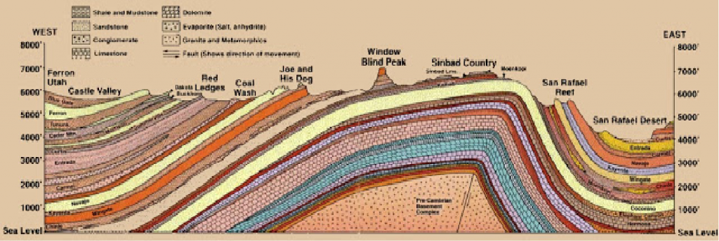
Faith, if a "depth of three miles of strata were originally laid down on the rock base of the continents" how could "a great deal of that strata" have been washed down into the sea since your flood scenario requires that sedimentary layers lithify under pressure within the space of a year or less? But it doesn't require that. All it requires is that they be compacted enough to hold their shape and resist erosion, which would be the case in the lower layers though not always the higher layers, which are the ones I figure would have been more likely to erode away. That cross section of the Grand Canyon-Grand Staircase area shows the strata above the Permian completely eroded away in the GC area and eroded away in steps up from there to the Claron in the GS area, but the layers from the Permian down remained intact. Chemical lithification would have occurred over time after that.
How much sediment would have to have been "loose" at the time of the flood in order to be transported and compose the layers we see today and which you insist were all laid down in your flood? Whatever there is in the strata which includes marine deposits as well, the limestones etc.
Wasn't there 1,500 years or so between the creation and the flood? Plenty of time for the strata to become solid enough to avoid being carried away by flood waters, no matter how turbulent. But there is no mechanism I can think of that could have formed such extensive deep layers EXCEPT the Flood, that's why I attribute them all to the Flood. Whatever form the sediments existed in before the Flood wouldn't have been strata. Edited by Faith, : No reason given. Edited by Faith, : No reason given.
|
|||||||||||||||||||||||||||||
|
Faith Suspended Member (Idle past 1474 days) Posts: 35298 From: Nevada, USA Joined: |
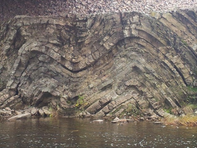
Yes, if sediment was laid down on top of the structures in that diagram, this would produce an angular unconformity such we can often see in the geological record. What of it? That's very clever and probably the only answer that at least superficially challenges what I'm saying. The thing is if a deposition did occur over that formation it would fill in the valleys and I haven't ever seen an angular unconformity in which the upper layers were anything but straight and flat both top and bottom, have you? Also the upper layers occur over tightly folded lower layers, I've never seen one form over the kind of base in that diagram, have you? In theory that could happen but in reality there's no evidence that it ever does that I know of. Perhaps you can find some but I doubt it. Edited by Faith, : No reason given. Edited by Faith, : No reason given.
|
|||||||||||||||||||||||||||||
|
edge Member (Idle past 1736 days)  Posts: 4696 From: Colorado, USA Joined: |
That's very clever and probably the only answer that at least superficially challenges what I'm saying. The thing is if a deposition did occur over that formation it would fill in the valleys ...
What valleys? I see no valleys in the picture.
... and I haven't ever seen an angular unconformity in which the upper layers were anything but straight and flat both top and bottom, have you?
Actually, yes, I have. It's called buried topography and an example would be the buried stream system that someone posted earlier based on seismic data.
Also the upper layers occur over tightly folded lower layers, I've never seen one form over the kind of base in that diagram, have you?
Yes. Siccar Point is an example. I have seen very deformed bedding planed off by by wave action and by stream channel development.
In theory that could happen but in reality there's no evidence that it ever does that I know of. Perhaps you can find some but I doubt it.
If you think that way, considering all of your training and experience, then I'm sure you are correct.
|
|||||||||||||||||||||||||||||
|
edge Member (Idle past 1736 days) Posts: 4696 From: Colorado, USA Joined: |
How could a layer of exposed, lithified sediment exist without layers that used to exist on top of it (since it is lithified and all)? If the flood can arrange fossils and sediments, why do some strata columns represent more "complete" timelines, while others seem to skip time creating those "gaps?"
I think that Faith's premise is that there has been only one period of deposition (the flood), one period of erosion/unconformity (the present), one period of magmatism (sometime after the flood), and only one period of deformation (also after the flood). Everything must fit into this paradigm. It's quite a straight-jacket, but with an overactive imagination, anything becomes possible. It's kind of like Harry Potter geology.
|
|||||||||||||||||||||||||||||
|
Coyote Member (Idle past 2136 days)  Posts: 6117 Joined: |
But there is no mechanism I can think of that could have formed such extensive deep layers EXCEPT the Flood, that's why I attribute them all to the Flood. Of course there is no mechanism you can think of! You are wearing self-imposed blinders that prevent you from seeing anything but what you want to see. In doing so, you are trying to force a particular view of the world onto nature, and to do that you must ignore most of what nature is trying to tell you. So it is not surprising to us that you can't think of a mechanism here.Religious belief does not constitute scientific evidence, nor does it convey scientific knowledge. Belief gets in the way of learning--Robert A. Heinlein How can I possibly put a new idea into your heads, if I do not first remove your delusions?--Robert A. Heinlein It's not what we don't know that hurts, it's what we know that ain't so--Will Rogers If I am entitled to something, someone else is obliged to pay--Jerry Pournelle If a religion's teachings are true, then it should have nothing to fear from science...--dwise1 "Multiculturalism" does not include the American culture. That is what it is against.
|
|||||||||||||||||||||||||||||
|
edge Member (Idle past 1736 days) Posts: 4696 From: Colorado, USA Joined: |
Note the large dip to the right.
Just by way of discolsure here. This picture, I'm pretty sure is from a limestone quarry somewhere in the eastern US. However, that does not detract from the point. I have seen identical structure in wave-cut terraces in Alaska, and if we cut a cross-section at the classic Siccar Point location, I'm sure it would look similar, though with different rock types.
Of course all unconformities are examples (I think) in spite of your fantasy of layers rolling around underground and being transported whole and unmarked by a magical water-like-but-doesn't-act-like-water fludde.
|
|||||||||||||||||||||||||||||
|
edge Member (Idle past 1736 days) Posts: 4696 From: Colorado, USA Joined: |
So it is not surprising to us that you can't think of a mechanism here.
You mean like normal depositional rates over long periods of time? You are correct, Faith cannot imagine such a thing.
|
|||||||||||||||||||||||||||||
|
Faith Suspended Member (Idle past 1474 days) Posts: 35298 From: Nevada, USA Joined: |
Please identify that formation, the folded part and the upper part. Thanks.
|
|||||||||||||||||||||||||||||
|
Percy Member  Posts: 22505 From: New Hampshire Joined: Member Rating: 4.9 |
Faith writes: That's very clever and probably the only answer that at least superficially challenges what I'm saying. I do agree that Dr Adequate is very clever, and not to take anything away from him, but Dr A only provided the answer geology uncovered centuries ago by examining the evidence. It isn't anything novel, except maybe to you.
The thing is if a deposition did occur over that formation it would fill in the valleys and I haven't ever seen an angular unconformity in which the upper layers were anything but straight and flat both top and bottom, have you? Deposited sediments will always conform to the surface of the landscape, and a number of diagrams and images have been presented during these geology discussions that show an irregular surface between one layer and the next, i.e., an unconformity. Your favorite diagram is at a huge scale but nonetheless includes an example:
Look at the top surface of the rightmost of the two angular uncomformities with the Grand Canyon supergroup. The Tapeats and the Bright Angel Shale have both been deposited around the bulge of the Shinumo layer of the supergroup. The layers did not deposit up the sides of the Shinumo because as a prominence on the landscape it would have been an object of net erosion.
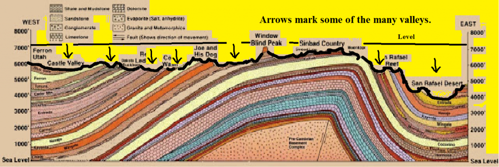
Also the upper layers occur over tightly folded lower layers, I've never seen one form over the kind of base in that diagram, have you? In theory that could happen but in reality there's no evidence that it ever does that I know of. Perhaps you can find some but I doubt it. Why do you only think it could happen in theory? If the region shown in this diagram were to become submerged:
Then whatever do you imagine would prevent sediments from filling it in? The lowest levels would be filled in first, then the rest, and eventually there would be a flat layer of sediment covering everything. --Percy
|
|||||||||||||||||||||||||||||
|
Percy Member Posts: 22505 From: New Hampshire Joined: Member Rating: 4.9 |
edge writes: That's very clever and probably the only answer that at least superficially challenges what I'm saying. The thing is if a deposition did occur over that formation it would fill in the valleys ...
What valleys? I see no valleys in the picture. If we're talking about this diagram:
Then I think she's referring to the right hand side. She's trying to say that there are no examples of sediments filling in a valley. --Percy
|
|||||||||||||||||||||||||||||
|
Faith Suspended Member (Idle past 1474 days) Posts: 35298 From: Nevada, USA Joined: |
I think that Faith's premise is that there has been only one period of deposition (the flood), one period of erosion/unconformity (the present), one period of magmatism (sometime after the flood), and only one period of deformation (also after the flood). Everything must fit into this paradigm. Oddly enough, I suppose, I don't start with any such premise, I am truly starting from observation of all those diagrams and pictures I've seen and they fit that scenario. The only real challenge to my conclusions is the angular unconformity and of course I dispute the usual idea of how those form. Eroding the lumpy surface flat enough for deposition to lay down neat horizontal layers that don't have to fill in the valleys is already beyond the possible (and if you can't see valleys in that diagram there's something wrong with your eyes), and such deposition could only happen by water anyway and where is that going to come from? Oh I know: in millions of years we can count on ANYTHING we need to satisfy the theory. Meanwhile we've got, in four diagrams so far (GC-GS, Great Britain cross section, Percy's of the Gulf of Mexico, and this one of Utah) what I've been calling the Geologic Column, all those layers that would have originally been stacked neatly and horizontally, obviously to a great depth in all those examples, probably in all cases even up to the Holocene level though that isn't apparent on this latest one or the one of Great Britain (just because they aren't labeled), still probably very close because that's a LOT of layers represented there. Anyway, four places where there was this original stack of horizontal layers that do customarily get labeled with time periods in the hundreds of millions, and after they are all laid down then and only then are they distorted: eroded, folded, sagging into a salt layer and so on. Four such examples so far. There must be more out there. And you all just blithely imagine more layers getting laid down on top of this formation. I find that eyepoppingly ludicrous and don't see why you don't.
|
|||||||||||||||||||||||||||||
|
edge Member (Idle past 1736 days) Posts: 4696 From: Colorado, USA Joined: |
Look at the top surface of the rightmost of the two angular uncomformities with the Grand Canyon supergroup. The Tapeats and the Bright Angel Shale have both been deposited around the bulge of the Shinumo layer of the supergroup. The layers did not deposit up the sides of the Shinumo because as a prominence on the landscape it would have been an object of net erosion.
A good point. In fact, it was an island in the Cambrian Sea. And the fact that it is a quartzite makes sense. It was more resistant to erosion.
|
|||||||||||||||||||||||||||||
|
edge Member (Idle past 1736 days) Posts: 4696 From: Colorado, USA Joined: |
Then I think she's referring to the right hand side. She's trying to say that there are no examples of sediments filling in a valley.
Ah, okay. Not into my first cup of coffee yet... Anyway, there is a little bit of a caveat here. To cover very steep topography, such as shown in the picture, it would either have to be the filling of a lake or very rapid sea level rise. If the former, you would have spatially restricted deposits, such as the Green River Formation. If the latter, you would usually have erosion of the entire region closer to sea level, such as in places like coastal plains, so that total relief would be less and the area would be inundated more quickly. It is hard for me to imagine this topography being overrun by the sea without a whole lot of erosion first. Even the valleys here are quite high in elevation.
|
|||||||||||||||||||||||||||||
|
Faith Suspended Member (Idle past 1474 days) Posts: 35298 From: Nevada, USA Joined: |
Edited by Admin, : Fix image so it isn't a link to PhotoBucket.
|
|||||||||||||||||||||||||||||
|
|
Do Nothing Button
Copyright 2001-2023 by EvC Forum, All Rights Reserved
![]() ™ Version 4.2
™ Version 4.2
Innovative software from Qwixotic © 2024