|

Understanding through Discussion |
|
|
Register | Sign In |
|
QuickSearch
| Thread ▼ Details |
|
Thread Info
|
|
|
| Author | Topic: Growing the Geologic Column | |||||||||||||||||||||||||||||||||||||||||||
|
Percy Member  Posts: 22505 From: New Hampshire Joined: Member Rating: 5.4
|
Faith writes: You're blind to the evidence for the Flood like everybody else here who has a vested interest in denying it. We're able to connect the evidence into a rational and consistent framework that takes into account our current understanding of geologic processes and of the laws of physics. You are unable to do this. All you've been able to do is make up irrational and contradictory stories.
If a rapid flow had created that plateau while its sedimentary layers were in a softer state then it would be teardrop shaped. Gosh you must have been there and seen exactly how the water flowed around those formations, huh? Since you weren't there either, don't you think it's time you dropped this silly objection? We know that rapid flows erode objects into teardrop shapes. We know this both from physics and from studying the natural world. Get on Google Maps and trace the Mississippi up from the delta and look at all the islands whose northern end is blunt and southern end is pointed. Even though the Mississippi flows relatively slowly along most of its course, the effect is still apparent. The tepui in question, Mt. Roraima, would be teardrop shaped were it eroded by a rapid flow, and other tepui in the region would also be teardrop shaped and all would be oriented in the same direction. Rapid flows erode differently than slow weathering, and these difference are the kind of evidence you should be seeking. At present you have no evidence for the formation of Mr Roraima by rapid flows.
The tepui are very hard rock, metamorphic, no doubt having been originally beneath the weight of a huge stack of strata above, and then the tectonic force that raised them would have also contributed to their hardening. See, I can answer your unprovable guesses with my own, and they're quite reasonable. Neither of us is making unprovable guesses. I'm providing the explanations of geology that are supported by a great deal of evidence, while you're making irrational and contradictory guesses. You claim your guesses are unprovable, but that's not really true because the evidence shows them demonstrably wrong.
And as you have been informed in return many times, rocks DO harden by drying, especially under compaction, The types of rocks we're talking about, sandstone, shale, siltstone, mudstone and limestone, do not form by drying. You're even wrong about compaction aiding drying, because compaction through burial could not accelerate any drying process because drying is an evaporative process. The water in buried layers does not evaporate. Compaction forces the water out from the pores in sedimentary deposits. Read the Wikipedia article on Lithification:
Wikipedia on Lithification writes: Lithification (from the Greek word lithos meaning 'rock' and the Latin-derived suffix -ific) is the process in which sediments compact under pressure, expel connate fluids, and gradually become solid rock. Essentially, lithification is a process of porosity destruction through compaction and cementation. Lithification includes all the processes which convert unconsolidated sediments into sedimentary rocks. Petrification, though often used as a synonym, is more specifically used to describe the replacement of organic material by silica in the formation of fossils. Once the pressure of overlying layers is removed through erosion then lithification will cease. If rock really hardened by drying then the top portion of, for just one example, the Kaibab at the Grand Canyon would be harder than the buried portion, which being buried couldn't dry. But it isn't drying that makes rock. It is compaction from the pressure of overlying layers.
A long time ago I posted something from a geology website that said compaction is even sufficient sometimes for lithification itself. You're raising this point in a way that makes it seem like you think it is something we might object to. But on the contrary, this is a completely accurate point. Compaction alone can produce rocks from unconsolidated sediments, and compaction and cementation can also.
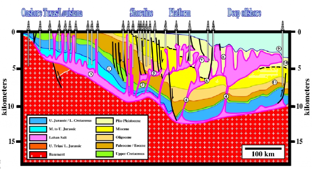
ABE: Also, that diagram you keep posting does not show what you think it shows. It no more shows the accumulation of sediment on the Geo Column than the cross section of the Grand Staircase does. That diagram shows sedimentary layers right up to the Plio-Pleistocene, which includes today. And the diagram, or at least the marine portion, is of the Gulf of Mexico, which is rapidly accumulating sediments. So the diagram shows sedimentary layers accumulating atop a geologic column stretching all the way back to the Jurassic. The geologic column is still growing today. --Percy
|
|||||||||||||||||||||||||||||||||||||||||||
Faith  Suspended Member (Idle past 1474 days)  Posts: 35298 From: Nevada, USA Joined: |
Your snarky discussion of the salt in that diagram as if I'd never heard of such a thing is what I'm reacting to. The salt isn't the issue in the diagram, just the deposition of sediments according to Percy. If you think that is shown, fine, it just looks like any geo column to me with all the strata one on top of another. Sagging because of the salt of course.
|
|||||||||||||||||||||||||||||||||||||||||||
|
Faith Suspended Member (Idle past 1474 days) Posts: 35298 From: Nevada, USA Joined: |
There are no unevidenced beliefs in my discussion of that diagram that edge obviously can't understand. I wasn't talking to you. Mind hyour own business.
ABE: Nobody has shown any evidence against what I've been arguing, that's the problem, edge just can't read. Edited by Faith, : No reason given. Edited by Faith, : No reason given.
|
|||||||||||||||||||||||||||||||||||||||||||
|
Coragyps Member (Idle past 764 days) Posts: 5553 From: Snyder, Texas, USA Joined:
|
Yup. The strata are certainly on top of each other. But the salt, which is all Triassic in age of its falling out of water, is found in a proper Triassic spot, in a layer way up above that, and in "stocks" where it is flowing from below to above. The point is that it is taking a very long time to get up there.
|
|||||||||||||||||||||||||||||||||||||||||||
|
RAZD Member (Idle past 1435 days)  Posts: 20714 From: the other end of the sidewalk Joined: |
cognitive dissonance ...
 by our ability to understand Rebel☮American☆Zen☯Deist ... to learn ... to think ... to live ... to laugh ... to share. Join the effort to solve medical problems, AIDS/HIV, Cancer and more with Team EvC! (click)
|
|||||||||||||||||||||||||||||||||||||||||||
|
Faith Suspended Member (Idle past 1474 days) Posts: 35298 From: Nevada, USA Joined: |
Not as long as you think.
ABE And by the way, speaking of sediments continuing to deposit there, shouldn't they be forming a horizontal upper surface? Isn't that what fresh loose sediments do, especially in water? Or maybe more to the point, if they are supposed to be forming the next layer in the Geo Column that IS what they would need to do but they don't seem to be doing that, just following the general deformation of the column. Edited by Faith, : No reason given. Edited by Faith, : No reason given.
|
|||||||||||||||||||||||||||||||||||||||||||
|
Faith Suspended Member (Idle past 1474 days) Posts: 35298 From: Nevada, USA Joined:
|
Sorry for the namecalling.
Edited by Faith, : No reason given.
|
|||||||||||||||||||||||||||||||||||||||||||
|
Coragyps Member (Idle past 764 days) Posts: 5553 From: Snyder, Texas, USA Joined:
|
Longer than you think, Faith. Like tens of thousands of times longer.
See, I can play "back atcha" too. They are forming a substantially horizontal upper surface. That diagram maps well over a hundred miles of real estate, and the altitude difference from Lafayette to the continental shelf is less than a mile. Vertical exaggeration is the norm in geological maps - like 100:1 exaggeration. Like in Grand Staircase geological maps.
|
|||||||||||||||||||||||||||||||||||||||||||
|
Faith Suspended Member (Idle past 1474 days) Posts: 35298 From: Nevada, USA Joined: |
That is not a horizontal surface no matter how much vertical exaggeration there is. And such exaggeration in the GS bears on absolutely nothing I've ever discussed about it so why bring it up.
Let's see. If that "Triassic" salt has supposedly been rising for millions of years but if the reality is it's been rising for only a few thousand I wonder when we might expect those domes to surface in real time rather than OE fantasy time. Anybody calculated their rate of rise? Edited by Faith, : No reason given.
|
|||||||||||||||||||||||||||||||||||||||||||
|
RAZD Member (Idle past 1435 days) Posts: 20714 From: the other end of the sidewalk Joined:
|
and you are the poster-child, Faith, I am just amazed at the lengths you go to in order to twist things up in your fantasy .... I keep waiting for the other shoe to drop and you realize that reality does not support your concepts.
Especially when there is so much evidence from so many different avenues of scientific knowledge which are consilient in so many details. It's like you are trying to halt an avalanche one snowflake at a time.  Edited by RAZD, : clrtyby our ability to understand Rebel☮American☆Zen☯Deist ... to learn ... to think ... to live ... to laugh ... to share. Join the effort to solve medical problems, AIDS/HIV, Cancer and more with Team EvC! (click)
|
|||||||||||||||||||||||||||||||||||||||||||
|
Faith Suspended Member (Idle past 1474 days) Posts: 35298 From: Nevada, USA Joined: |
Here's that diagram with a dotted line added to show exactly where the Plio-Pleistocene divides from the Miocene, which I did because my eyes are getting bad and it was hard to make out that boundary.
That looks like a layer that was already there to me, that got deformed right along with the others as the salt worked on them, not new sediments at all. And the salt has certainly gone right up through it too.
|
|||||||||||||||||||||||||||||||||||||||||||
|
Faith Suspended Member (Idle past 1474 days) Posts: 35298 From: Nevada, USA Joined: |
deleted
Edited by Faith, : No reason given. Edited by Faith, : taking back angry talk
|
|||||||||||||||||||||||||||||||||||||||||||
|
Faith Suspended Member (Idle past 1474 days) Posts: 35298 From: Nevada, USA Joined: |
Here's a version of that diagram where I've argued that you can tell by the pattern of fault lines that the strata, up to the Base tertiary, were already all in place when the faulting and deformation occurred. I'd also argue that the salt dome pushing up through the Base tertiary includes that layer ni the same order of things despite the fact that the faults don't go up through it. In any case you can prove by the fault lines which strata were already in place but you can't prove by the absence of faults that a particular layer wasn't already in place with the rest of them
|
|||||||||||||||||||||||||||||||||||||||||||
|
herebedragons Member (Idle past 887 days)  Posts: 1517 From: Michigan Joined: |
Luke 6: 27 - 31
quote: Just saying, your supposed to be the righteous one among us. HBDWhoever calls me ignorant shares my own opinion. Sorrowfully and tacitly I recognize my ignorance, when I consider how much I lack of what my mind in its craving for knowledge is sighing for... I console myself with the consideration that this belongs to our common nature. - Francesco Petrarca "Nothing is easier than to persuade people who want to be persuaded and already believe." - another Petrarca gem. Ignorance is a most formidable opponent rivaled only by arrogance; but when the two join forces, one is all but invincible.
|
|||||||||||||||||||||||||||||||||||||||||||
|
Faith Suspended Member (Idle past 1474 days) Posts: 35298 From: Nevada, USA Joined: |
Much later: Taking it all back. It's poisoning me.
Edited by Faith, : No reason given.
|
|||||||||||||||||||||||||||||||||||||||||||
|
|
Do Nothing Button
Copyright 2001-2023 by EvC Forum, All Rights Reserved
![]() ™ Version 4.2
™ Version 4.2
Innovative software from Qwixotic © 2024
 (1)
(1)