|

Understanding through Discussion |
|
|
Register | Sign In |
|
QuickSearch
| Thread ▼ Details |
|
Thread Info
|
|
|
| Author | Topic: Exploring the Grand Canyon, from the bottom up. | |||||||||||||||||||
|
Minnemooseus Member  Posts: 3945 From: Duluth, Minnesota, U.S. (West end of Lake Superior) Joined: Member Rating: 10.0 |
This is again getting into being something that could well be a topic in itself.
Most sea level changes (correct me rox or IHR or edge) that you see in transgression/regression sequences occur due to the cyclic nature of ice ages on earth. Such can be the causes, but it is a relatively minor effect. The cause of major sea transgressions onto land is thought to be because of major increases in seafloor spreading rates. I'm not going to get into the details of why and how the effect happens, but essentially, increased spreading rates cause the sea floor to rise to higher levels. This in turn causes sea level to rise, and displaces water onto the continents. Of course, since the volume of the Earth remains constant, this rise in sea floor levels strongly implies a fall in the levels of the continental crust. To visualize what I mean by level, think distances of the oceanic and continental crust surfaces from the center of the earth. I think this has previously been covered elsewhere, with Joe Meert being the primary contributor of information. Probably the discussion has been mostly in topics relating to Baumgardner's (sp?) catastrophic sea floor spreading ideas. Moose
|
|||||||||||||||||||
|
jar Member (Idle past 424 days)  Posts: 34026 From: Texas!! Joined: |
Thanks moose, and yes it could be a thread in and of itself. In this case though we are looking at one very specific incident.
In the case of the Bass Formation, is there any way we can tell what happened? If not, then we just include both possibilities. Aslan is not a Tame Lion
|
|||||||||||||||||||
|
Jazzns Member (Idle past 3941 days)  Posts: 2657 From: A Better America Joined: |
I don't know if it was brought up or needs to be brought up but the description of the sea level changes takes in the existance of the specific layer we are talking about and its relationship to the other layers in the group. So the conclusion about the changes are more of a big picture type of concusion instead of something that you get just from looking at the Bass Limestone.
I know you spoke about how you wanted to just take it a layer at a time. Then you may want to just postpone any discussion of this until we finish this group since it relates to all the layers in this group not just the Bass. Of course, biblical creationists are committed to belief in God's written Word, the Bible, which forbids bearing false witness; --AIG (lest they forget)
|
|||||||||||||||||||
|
roxrkool Member (Idle past 1018 days)  Posts: 1497 From: Nevada Joined: |
A few things:
1. Conglomerate does not require increased pressure or temperature. Just the rounded material and some amount of finer grained matrix. If there is more cobbles than matrix, it is called a clast-supported conglomerate. If there is more matrix, it is called a matrix-supported conglomerate. A conglomerate that has been subjected to increased pressure and temperature, but still retains its conglomeratic appearance, would be called a meta-conglomerate. 2. First, I should point out that there are absolute and relative fluctuations in sea level. Absolute fluctions are globally felt and recorded (in the rock record), while relative fluctutations can be locally felt and recorded... I think that's right. Second, both jazz and moose are correct in that ice ages (growth and decay of ice sheets) and spreading rates (changes volume of ocean basins) affect relative sea levels, but so can tectonics (subsidence/uplift of land), increased rates of continental erosion (dumping a lot of seds into the ocean will displace water and raise sea levels), variations in how water is stored (groundwater, lakes, etc.), and thermal expansion and contraction of sea water (cold water causes seas to contract, warm water causes seas to expand). One way to figure out what caused a transgressive-regressive cycle is by looking at how formations behave locally over lateral distances and then globally. If you have a transgressive cycle in a couple basins in New Mexico, but nowhere else, then you might have a localized relative drop in sea level due to basin subsidence - which may be the result of faulting. If you see this transgressive sequence all over the world for similar aged rocks, then this rise is sea level is likely a global event. For the Bass Limestone, the following is technical, but discusses the depositional environment for the Grand Canyon Supergroup:
Tectonic inferences from the ca. 1255-1100 Ma Unkar Group and Nankoweap Formation, Grand Canyon: Intracratonic deformation and basin formation during protracted Grenville orogenesis The Unkar Group of the Grand Canyon Supergroup is one of the best-preserved remnants of Mesoproterozoic sedimentary rocks in the southwestern United States. It provides an exceptional record of intracratonic basin formation and associated tectonics kinematically compatible with protracted "Grenville-age" NW-directed shortening. New U/Pb age determinations from an air-fall tephra at the base of the Unkar Group dates the onset of deposition at ca. 1255 Ma, and 40Ar/39Ar K-feldspar thermochronology in the Grand Canyon indicates that basement rocks cooled through 150 C between ca. 1300 and 1250 Ma, refining exhumation rates of basement rocks just prior to Unkar deposition. Abrupt thickness and facies changes in conglomerate and dolomite of the Bass Formation (lower Unkar Group) associated with NE-striking monoclinal flexures indicate NW-directed synsedimentary contraction at ca. 1250 Ma. A large disconformity (~75 m.y. duration) is inferred between the lower and upper Unkar Group and is located below the upper Hakatai Shale, as documented by detrital zircons. A second style of Unkar Group deformation involved the development of half grabens and full grabens that record NE-SW extension on NW-striking, high-angle normal faults. Several observations indicate that NW-striking normal faulting was concurrent with upper Unkar deposition, mafic magmatism, and early Nankoweap deposition: (1) intraformational faulting in the Bass Formation, (2) intraformational faulting in the 1070 Ma (old Rb/Sr date) Cardenas Basalt and lower Nankoweap Formation, (3) syntectonic relationships between Dox deposition and 1104 Ma (new Ar/Ar date) diabase intrusion, and (4) an angular unconformity between Unkar Group and Nankoweap strata. The two tectonic phases affecting the Unkar Group (ca. 1250 Ma and ca. 1100 Ma) provide new insight into tectonics of southern Laurentia: (1) Laramide-style (monoclines) deformation in the continental interior at ca. 1250 Ma records Grenville-age shortening; and (2) ca. 1100 Ma detrital muscovite (Ar/Ar) and zircon (U/Pb) indicate an Unkar Group source in the Grenville-age highlands of southwestern Laurentia during development of NW-striking extensional basins. We conclude that far-field stresses related to Grenville-age orogenesis (NW shortening and orthogonal NE-SW extension) dominated the sedimentary and tectonic regime of southwestern Laurentia from 1250 to 1100 Ma.
SOURCE So basically, the GC Supergroup transgressive-regressive sequences appear to be the result of tectonics. This message has been edited by roxrkool, 03-21-2006 05:50 PM
|
|||||||||||||||||||
|
jar Member (Idle past 424 days) Posts: 34026 From: Texas!! Joined: |
roxrkool writes: So basically, the GC Supergroup transgressive-regressive sequences appear to be the result of tectonics. So basically we can say that there is evidence that the Bass Formation and the other ones we will discuss in looking at the Grand Canyon Supergroup are the result of tectonics, the actual movement to the surface up, down, and as we will see once we get to the end of the Supergroup, side-toside and tilting. And I stand corrected on the conglomerates and will correct that in the next summary. Aslan is not a Tame Lion
|
|||||||||||||||||||
|
jar Member (Idle past 424 days) Posts: 34026 From: Texas!! Joined: |
A new term, two infact, came up in Roxrkools last post.
Horsts and Grabens. From what I can find out they are the result of faulty, the Horst being the relatively upthrust body while the Graben is the relatively lowered one. Together they would form a series of hills and valleys bounded by fault lines. It would seem that these are very indicative of tectonic activity. Is this what is refered to in the discussion of the Bass Formation? Is what is shown this page an explanation of Horsts and Grabens? Finally, on the page referenced above there is an animation called Fold Trains in Ireland. On the lower left of the picture I notice that many of the layers seem to be cut off at the overlay. Is this the kind of evidence that shows an Unconformity, that part of what was there is missing? Aslan is not a Tame Lion
|
|||||||||||||||||||
|
edge Member (Idle past 1736 days)  Posts: 4696 From: Colorado, USA Joined: |
From what I can find out they are the result of faulty, the Horst being the relatively upthrust body while the Graben is the relatively lowered one. Together they would form a series of hills and valleys bounded by fault lines. It would seem that these are very indicative of tectonic activity. Is this what is refered to in the discussion of the Bass Formation? Don't know.
Is what is shown this page an explanation of Horsts and Grabens? On a small scale, yes. Keep in mind that this can occur on a regional scale, as well.
Finally, on the page referenced above there is an animation called Fold Trains in Ireland. On the lower left of the picture I notice that many of the layers seem to be cut off at the overlay. Is this the kind of evidence that shows an Unconformity, that part of what was there is missing? I don't see anything unusual in the lower left of the picture. What do you see? The unconformity is at the top of the folde rocks.
|
|||||||||||||||||||
|
jar Member (Idle past 424 days) Posts: 34026 From: Texas!! Joined: |
Yes, at the left below the smoother layer.
Aslan is not a Tame Lion
|
|||||||||||||||||||
|
roxrkool Member (Idle past 1018 days) Posts: 1497 From: Nevada Joined: |
That's a really nice website, jar. Good for beginners.
Horsts and grabens are the result of extension and the entire Basin and Range Province is the result of this type of tectonics - at a much larger scale than shown in that link of yours, however.
Is this what is refered to in the discussion of the Bass Formation?
What I picture when I read the description above is this: imagine placing a ball of dough between your hands, which are parallel to each other. Bring your hands together slowly - this is called the direction of compression or the shortening direction. Compressing the dough causes the ball of dough to squish up between your hands (similar to mountain building). However, not only is the dough moving upwards, it is also moving in the orthogonal direction, which is 90 degrees from the direction of shortening. The dough is extending outwards toward your fingertips and wrists because it's just as easy or easier for the dough to spread out in that direction than to continue going straight up between your hands. The direction in which the dough is moving outwards, towards your fingertips, is the direction of extension. Extension can result in horsts and grabens. So you are getting both compression and extension happening at the same time. I should remind you that this compressional event is entirely separate from the one that formed the Vishnu Schist. Under compression (increased pressure), rocks behave plastically, but under extension, rocks are brittle. So compression results in folding, deformation, metamorphosis, etc., but because it becomes easier for the crust to move laterally instead of straight up, they start extending in the orthogonal direction, forming horsts and grabens. It's my understanding that the lower half of the Unkar Group was deposited early in the compressional history during regional folding and deformation (the monoclinal flextures) and the upper half was deposited when the crust started extending (horsts and grabens). Abe: I've actually never heard of the term 'fold trains' - same thing as chevron folds? And older term or European? This message has been edited by roxrkool, 03-21-2006 10:38 PM
|
|||||||||||||||||||
|
jar Member (Idle past 424 days) Posts: 34026 From: Texas!! Joined: |
Under compression (increased pressure), rocks behave plastically, but under extension, rocks are brittle. So compression results in folding, deformation, metamorphosis, etc., but because it becomes easier for the crust to move laterally instead of straight up, they start extending in the orthogonal direction, forming horsts and grabens. Okay, great info. So you are saying that under pressure rocks will fold and deform. I assume this has been tested in the lab and that under pressure you can actually bend rock that normally would break. Is that correct? So when geologists see something like this or this you good folk know that it happened after the rock had hardened and under pressure and not as some folk claim while the rock was soft and muddy. Aslan is not a Tame Lion
|
|||||||||||||||||||
|
roxrkool Member (Idle past 1018 days) Posts: 1497 From: Nevada Joined: |
Yes, rock deformation labs all over the world have performed these sorts of experiments.
Actually, jar, I think that second image may be an angular unconformity, but the first one is nice. Rock deformation affects the integrity of the rock and hence, the minerals that make up that rock. The minerals in unconsolidated sediment will not be affected by strain (or other metamorphic effects) because the minerals can freely move about.
|
|||||||||||||||||||
|
jar Member (Idle past 424 days) Posts: 34026 From: Texas!! Joined: |
Actually, jar, I think that second image may be an angular unconformity, but the first one is nice. Great. That tells me that there really are things you see that us amateurs don't unless it is pointed out to us. I would like to see if these old eyes of mine can be taught to dance. Is this an example of an angular unconformity, in fact a few of them?
At least two angular unconformities one with the point to the left, the other pointing right and lower on the face. Aslan is not a Tame Lion
|
|||||||||||||||||||
|
jar Member (Idle past 424 days) Posts: 34026 From: Texas!! Joined: |
and where we are going.
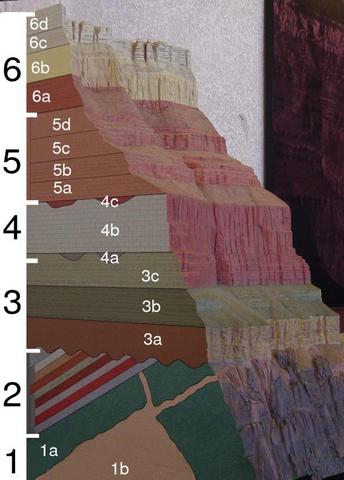
I'd like to pause for a moment (and will repeat this periodically throughout this discussion) so folk can visualize where we are in the Grand Canyon and get a feel for what will be coming. Here is a drawing of the Grand Canyon I'll use as our position indicator as we move from John Wesley Powell's view, down in the bottom, up towards the top. Right now we have covered 1a and 1b, and we are looking at the very first layers of group 2.
As you can see, we have a ways to go to get to the top. I hope that in the remaining posts of this thread that we can get through all of group 2 and get a summary of the wonderous story to be found just in these bottom sections. Note that the layers in Group 2 are tilted. I don't want to deal with that issue until we've first covered all of them as they were created. Let's first build the layer cake, and then hopefully still have enough posts in this thread to discuss how they became tilted, and what we can learn both from what is seen, and what is missing. Aslan is not a Tame Lion |
|||||||||||||||||||
|
roxrkool Member (Idle past 1018 days) Posts: 1497 From: Nevada Joined: |
Another nice picture. Those do appear to be angular unconformities. The upper one shows a nice erosional channel, too (just above center).
|
|||||||||||||||||||
|
jar Member (Idle past 424 days) Posts: 34026 From: Texas!! Joined: |
The upper one shows a nice erosional channel, too (just above center). Great, that was going to be the next question I asked you. So another new term to define. Erosional channel. Let's see if I understand what you are saying. What we see here is a channel that was cut in the surface, perhaps by a stream or wind or glacier. It was then filled in over time until the surface was level again. We can tell it was an erosional channel because layers are interrupted on the right and left, missing in the channel itself, and new material deposited there. Is that what we are seeing? Aslan is not a Tame Lion
|
|||||||||||||||||||
|
|
Do Nothing Button
Copyright 2001-2023 by EvC Forum, All Rights Reserved
![]() ™ Version 4.2
™ Version 4.2
Innovative software from Qwixotic © 2024