|

Understanding through Discussion |
|
|
Register | Sign In |
|
QuickSearch
Summations Only | Thread ▼ Details |
|
Member  Posts: 3945 From: Duluth, Minnesota, U.S. (West end of Lake Superior) Joined: Member Rating: 10.0 |
|
Thread Info
|
|
|
| Author | Topic: Continuation of Flood Discussion | |||||||||||||||||||||||||||||||||||||||||||||
|
edge Member (Idle past 1736 days)  Posts: 4696 From: Colorado, USA Joined: |
If Faith's erosive flood caused the spires and buttes in Monument Valley wouldn't they all have a characteristic teardrop shape, as seen from above? And I would expect that the shape would be relative to the direction of water flow.
Excellent point. That is something that most of us would call 'evidence'.
|
|||||||||||||||||||||||||||||||||||||||||||||
|
edge Member (Idle past 1736 days) Posts: 4696 From: Colorado, USA Joined:
|
I did say that the Missoula flood was a limited flood and not THE Flood of Noah itself, and that I figure Lake Missoula was one of the bodies of water left standing after the Flood. I also think that the tectonic activity after the Flood is probably the cause of their emptying but I'd have to spend some time on each one specifically for that.
Good. That is something that is testable and possibly provides observable evidence. What have you got?
I did give my scenario for how the receding Flood waters made the formations of the Southwest, though, more than once I think, but I guess I can give it again. Already did so, below.
A scenario is not evidence.
Think ocean, not just any old "flood." This is the ocean having transgressed the land to quite a depth, and it's now receding. That's a LOT of water, we're talking water that would break up the strata it had just laid down, even break it up to a depth of a mile or so, break it into huge chunks and carry it off, even into cracks that widen into a Grand Canyon.
Okay so the ocean needs to regress catastrophically. What is the mechanism and what would be the evidence to support that hypothesis? Just saying that the ocean receded is not evidence.
Percy's diagram has the surface of Monument Valley arched so that cracks develop here and there, which makes the Flood scenario even easier to explain. Water running across a fairly flat surface will nevertheless develop tracks and if it cuts at all into the surface will follow that cut. I figure that's how it cut around areas of strata to some depth, which then of course remained as the buttes, which became the monuments after the whole area had dried out. If the land was arched and cracks developed as a result, so much easier to account for the tracking of the water around areas of strata.
OKay, now, what is the diagnostic evidence for your scenario? That's what we want from you. Otherwise, you are doing nothing but making things up.
Again, I think the best evidence that water was the agent of the erosion is the flat plain around the monuments. I know you think that over hundreds of millions of years somehow or other that flat plain would have formed just by the processes of normal wind and weathering erosion. Seems to me what that would have left is a very chunky landscape, not a plain. ...
No one debates the effectiveness of erosion by water. We want to know what is different about your water, how it got there and what evidence do you have for your scenario. And I have snipped your little complaint. Why would millions of years of flash flooding and wind erosion leave a 'chunky appearance'?
Well, I do think if you thought carefully about it you'd have to stop your incessant party line long enough to consider that it really IS odd that so much happened in "recent" time, since the last of the strata, the Tertiary, Claron etc., was laid down, while all those strata just lay there for hundreds of millions of years, under water most of the time according to Percy, but that's odd too.
You have not made an argument as to why this is so. You only confirm my statement that you speak only from personal incredulity, saying we have to 'think about it more'. That is not evidence, nor is it an argument.
Hundreds of millions of years quietly accumulating underwater and then they surface for all this massive erosion to a mile deep or so. Yes I do think that is quite odd and not to be casually explained away. But that's what you're doing and I guess you'll go on doing it.
So, your evidence is that you think it is 'quite odd'. Your threshold for oddness sets quite a low standard. I have a feeling that we are not getting through to you on this notion of 'evidence'. What can we do to help you?
|
|||||||||||||||||||||||||||||||||||||||||||||
|
edge Member (Idle past 1736 days) Posts: 4696 From: Colorado, USA Joined: |
And your source of knowledge that there was tectonic activity associated with the alleged flood is what exactly?
Such tectonic activity should lend even more potential evidence for Faith's scenario especially if they could be tied together in time. Is that tectonic activity and different than the tectonic activity we see today? Think we'll see anything like that?
|
|||||||||||||||||||||||||||||||||||||||||||||
|
edge Member (Idle past 1736 days) Posts: 4696 From: Colorado, USA Joined:
|
This site shows what catastrophic runoff leaves behind.
Ice Age Floods-Discover Glacial Lake Missoula and Lake Bonneville This image shows megadunes related to the Lake Missoula flooding:
And this one shows that Lake Missoula actually existed:
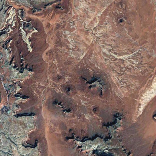
These things are known as 'evidence'. In your case, I neither see the assymetric features of a catastrophic runoff, nor even that fact that some impoundment existed to create such a flood. When I look at a google-earth image, I do not see any regional flow directions in Monument Valley, just a normal dendritic pattern that we see with normal stream flow on flat-lying strata. I will track down more images if I don't get a call to work.
|
|||||||||||||||||||||||||||||||||||||||||||||
|
edge Member (Idle past 1736 days) Posts: 4696 From: Colorado, USA Joined:
|
Good grief, once in a GREAT while I give the Biblical background and you try to pretend everything I've said is derived from it. No, I've been referring to actual physical information and never refer to the Biblical source. I did so in this case to correct the statement that a YEC sees the planet as "final and complete" which does not describe how we see it.
You referred to actual data? I missed that. Please re-post.
|
|||||||||||||||||||||||||||||||||||||||||||||
|
edge Member (Idle past 1736 days) Posts: 4696 From: Colorado, USA Joined:
|
It IS evidence, as I acknowledged. But it doesn't kill the idea of water doing the erosion, it just suggests it didn't all run in one direction. Many different sources perhaps.
Who said that we deny the effectiveness of erosion by water? You misrepresent our arguments. And why would water not run in a down-slope direction?
|
|||||||||||||||||||||||||||||||||||||||||||||
|
edge Member (Idle past 1736 days) Posts: 4696 From: Colorado, USA Joined:
|
This image shows a space-view of a part of Monument Valley. It shows no unidirectional flow patterns that occur in other catastrophic flood locations such as in the case of Lake Missoula flooding. The pattern is pretty much dendritic, though there may be some structural controls.
If, as Faith suggests (getting deeper and deeper) that water flowed in multiple directions (northeast and northwest alignments), I would like to know why that would happen. In all erosive floods that we know about the flows are in one direction, which is down-gradient.
|
|||||||||||||||||||||||||||||||||||||||||||||
|
edge Member (Idle past 1736 days) Posts: 4696 From: Colorado, USA Joined:
|
Well I still like my post 328 with all the diagrams of the GC-GS area because that massive erosion did all occur after all the strata were in place, ...
You mean after 1.) the Paleozoic strate were in-place, 2.) and at the location of the Grand Canyon, and 3.( with lesser erosional unconformities included. But your point is what? No one debates this.
... which I would attribute partly to tectonic activity.
Please explain. I have no idea what you are talking about here.
Also the magma dike and the faulting illustrated there, not to mention the cliffs and the canyons which were no doubt facilitated by same tectonic shakeup.
You have not shown that there was a 'shake-up'.
All after all the strata were in place, ...
Yes, you said that already.
... which can be seen on the diagram. That post is great evidence for the Flood, yes, actual evidence.
If so, it is also good evidence for mainstream geological interpretation. Please find us some diagnostic evidence for why your particular scenario occurred.
Takes a bit of divesting of Old Earth bias though in order to consider it properly.
So, you admit that you have to have a young-earth presupposition before interpreting the data?
Take it to a high mountain, assume lotus position, think.
If YEC prevails, I'm afraid we will need to assume the bend-over position and refrain from thinking.
|
|||||||||||||||||||||||||||||||||||||||||||||
|
edge Member (Idle past 1736 days) Posts: 4696 From: Colorado, USA Joined:
|
I'm talking about a lot more water than you are talking about, all at one time too.
More water than the Lake Missoula flooding? If so, shouldn't there be just as good evidence as for Lake Missoula? Where are the scablands, the potholes, the megadunes?
It would if there is a clear downslope direction for the whole plain, which there may not have been. Had to cut through layers first too, which would have had some effect on redirecting the water from level to level -- so I'd guess.
You are the one who said Monument Valley was a plain. Besides, we see directional flows from Lake Missoula. Why don't we see them in Monument Valley? Does that mean that this was a smaller flood? And I haven't really asked you why your flood was so catastrophic. Where did the water go so suddenly?
|
|||||||||||||||||||||||||||||||||||||||||||||
|
edge Member (Idle past 1736 days) Posts: 4696 From: Colorado, USA Joined:
|
No, I do not mean only Paleozoic, I mean all the way from Tapeats to Claron ...
Okay, so I should have said Phanerozoic, or most of it anyway. And by the way, IIRC, the Claron is partly lacustrine.
and the location is the entire GC GS area from bottom to top. Which is what I SAID.
But you ignore the Ancestral Rockies rising to the east of there, right?. You also ignore the Permian and Triassic island arcs offshore of the west coast at the time. Why constrain yourself to such a small corner of the world? And no, not bottom to top. You ignore the entire Precambrian which is actually a lot more time than the Phanerozoic.
|
|||||||||||||||||||||||||||||||||||||||||||||
|
edge Member (Idle past 1736 days) Posts: 4696 From: Colorado, USA Joined: |
No, it means being willing to set bias aside.
And your bias? Would you set that aside?
|
|||||||||||||||||||||||||||||||||||||||||||||
|
edge Member (Idle past 1736 days) Posts: 4696 From: Colorado, USA Joined: |
I'm interested in what's on the diagram, not what's off the diagram, because what's on the diagram makes the point.
Well, that's weird since the rocks shed from the Ancestral Rockies correlate with the middle of your Phanerozoic sequence.
I think of the Rockies as being tectonically raised after the Flood. I don't want to fight about my view of the angular unconformity, otherwise I'd include it because I believe all that too was laid down in the Flood. At least the strata were.
How do you get an erosional unconformity during a flood? Particularly an angular unconformity?
|
|||||||||||||||||||||||||||||||||||||||||||||
|
edge Member (Idle past 1736 days) Posts: 4696 From: Colorado, USA Joined:
|
Here comes the tectonic activity associated with the end of the imagined floods. After all, that raised the Rockies which caused all the water to slosh east and wash away the Appalachians.
Never mind that fact that you would have to explain, then, where and when the Appalachians came from. YECs just keep on digging. I'm really curious about how Faith is going to explain this tectonic event that causes the flood, causes the flood to recede, causes post-flood erosion and causes tectonism in the basement rocks all at the same time. Bring popcorn...
|
|||||||||||||||||||||||||||||||||||||||||||||
|
edge Member (Idle past 1736 days) Posts: 4696 From: Colorado, USA Joined:
|
The angular unconformity occurred, in my humble opinion. as a result of the tectonic activity AFTER the Flood. I know it's hard to keep the thoughts of a silly creationist in mind but I HAVE said this many times by now.
While I can imagine some scenarios for intraformational disruption, all of them leave behind obvious and diagnostic evidence which is absent in the Grand Canyon section. In fact, the evidence leads to the contrary. You may think what you want, but I hope you will understand why we oppose wishful science in the classroom.
That disturbance raised the whole stack, and it was also associated with the release of the volcano or volcanoes beneath the canyon area which issued in lava flows here and there and intrusions into the Precambrian rocks ...
Except that some of them are not intrusions...
,,, and the magma dike to the north of the GS which issued in lava at the top of the strata there.
All we are asking is for evidence.
You can tell all the strata were already in place because the dike just goes straight from bottom to top. It didn't occur during the laying-down of the strata.
Not the Cardenas Basalt.
Same with the faults, which split the strata from bottom to top.
The younger faults, yes. So what? We know that the region was uplifted sometime in the Tertiary Period.
An angular unconformity was the result to the north of the northernmost fault, with the Claron remaining horizontal over the tilted strata.
This is a cross-cutting relationship establishing relative age. If you want to prove otherwise, please do so. Your assertion is not evidence.
There you have an example of an angular unconformity where the horizontal strata were clearly NOT laid down after the lower strata were tilted, because clearly the whole block of strata just dropped on the north side of the fault line, breaking off from the strata on the south side, all as a block. The Claron was broken also, was not deposited after the fault or it would not have deposited flat up against the fault line like that and the upper part of it would have fallen over the cliff and piled up. So there's an angular unconformithy that fits my model.
Do you think that faults only move once? Sorry, but the Hurricane Fault system is long lived. The Claron is deformed, but the underlying rocks are deformed even more. We call that a 'growth fault' (although the term is usually applied to faults that do not crop out). So, no, you still have not provided any diagnostic evidence for your scenario.
|
|||||||||||||||||||||||||||||||||||||||||||||
|
edge Member (Idle past 1736 days) Posts: 4696 From: Colorado, USA Joined: |
Oh. The tectonic activity did NOT "cause the Flood." I do think it's connected with the receding of the Flood though, which is the cause of the massive erosion that I've circled in Message 328
So, where did this tectonism occur and why? How did it cause catastrophic runoff of the flood waters? How does that relate to the tectonism that disrupted the Vishnu rocks and the GC Supergroup rocks?
...and the angular unconformities and the faultings and the volcanism with the magma dikes and intrusions and so on. All stuff that didn't happen until all the strata were in place.
The faults you see are mostly normal faults that formed in tension, including the Hurricane Fault. On the other hand, the kind of disruption you (claim to) see in the GC Supergroup would be related to lateral shear or compression. How do you rationalize these disparate strain regimes?
|
|||||||||||||||||||||||||||||||||||||||||||||
|
|
Do Nothing Button
Copyright 2001-2023 by EvC Forum, All Rights Reserved
![]() ™ Version 4.2
™ Version 4.2
Innovative software from Qwixotic © 2024

 (1)
(1)