|

Understanding through Discussion |
|
|
Register | Sign In |
|
QuickSearch
| EvC Forum active members: 59 (9164 total) |
|
| |
| ChatGPT | |
| Total: 916,929 Year: 4,186/9,624 Month: 1,057/974 Week: 16/368 Day: 16/11 Hour: 0/0 |
Summations Only | Thread ▼ Details |
|
Member  Posts: 3945 From: Duluth, Minnesota, U.S. (West end of Lake Superior) Joined: Member Rating: 10.0 |
|
Thread Info
|
|
|
| Author | Topic: Continuation of Flood Discussion | |||||||||||||||||||||||||||||||||||||||||||
|
edge Member (Idle past 1737 days)  Posts: 4696 From: Colorado, USA Joined: |
You really are committed to finding the most trivial objections to anything I say. But why should I expect anything else?
Correct. If you are trying to unseat the established explanation, you should be prepared to answer detailed questions. That's what we do in science; as opposed to religion where conclusions are never allowed to be questioned.
|
|||||||||||||||||||||||||||||||||||||||||||
|
edge Member (Idle past 1737 days) Posts: 4696 From: Colorado, USA Joined: |
Disclaimer - General impressions without that much specific data to back them (thus weasel words such as "seem to" and "suspect" used).
Generalizations? Here? No way! "Random" is kind of a subjective term, but you are correct.
I suspect that there is indeed some shape and preferred orientation, although it would be because of structural control and not "the flood".
This is always a good default position in western North America. I think that some earlier posts referred to these directions.
In photos the messas seem to at least sometimes have a rectangular plan view outline. In this map, the Oljeto Mesa appears to be generally rectangular with a northwest-southeast orientation of the long axis. There also seems to be some sort of northeast-southwest component there. To some degree, these orientations can also be seen in other mesas.
Even in Colorado, one of the principal structural directions is N40E.. Just say that, and 90% of the time, you will be right. I suspect (and closer study could confirm or deny such) that there is a strong regional orthogonal joint pattern that influences the weathering and erosion patterns (related reading on geology fractures). Ain't life wonderful?
|
|||||||||||||||||||||||||||||||||||||||||||
|
edge Member (Idle past 1737 days) Posts: 4696 From: Colorado, USA Joined: |
Here's a bigger version of the image of what Edge called megadunes but that are described at the website as giant ripples (click to expand):
Yes, the story here is that although the dunes follow low areas across the countryside, there is no stream channel. The flows have exceeded the capacity of the existing streams by orders of magnitude. Note also that these features are not eroded away by flowing water, but are deposited by flowing water. There are a number of other features related to this 'breakout' type of flood, but I decided to focus on this one that is not as well known as some of the others.
Edge will have to confirm, but I believe he presented this image as evidence of the existence of Lake Missoula because the vertical lines across the mountain side are ancient shorelines.
I probably should have elaborated on these images, but I was kind of curious to see if Faith would take an interest and ask about them. Yes, the (horizontal) lines are ancient shorelines. There are a large number of them on the mountainside east of Missoula. One theory is that each represents a different generation of Lake Missoula. I'm not so sure about that, but they are definitely shorelines based on wave-washed sand deposits. These are common in many of the intermountain basins of western North America. The most interesting thing about them is that, for the larger lakes, they are presently arched and not perfectly level. This is because of isostatic rebound after removal of the huge amounts of water that previously filled the basin.
|
|||||||||||||||||||||||||||||||||||||||||||
|
edge Member (Idle past 1737 days) Posts: 4696 From: Colorado, USA Joined:
|
The rolling "megadunes" are interesting but what's the evidence that they are typical of rushing water everywhere?
They occur in other places with break-up type of flooding. This reference refers to some in Russia. See Giant current ripples - Wikipedia
"Giant current ripples are active channel topographic forms up to 20 m high, which develop within near-talweg areas of the main outflow valleys created by glacial lake outburst floods. Giant current ripple marks are morphologic and genetic macroanalogues of small current ripples formed in sandy stream sediments. The giant current ripple marks are important depositional forms in diluvial plain and mountain scablands.[1] Isn't that area basalt?
The basalt country rock would affect the way that the rocks erode, the giant ripples are a depositional feature.
Is it possible basalt would ripple like that while other sediments might not? Also were layers above that layer also washed away in the same event? This is what I've been guessing for the Monument Valley area and I'm not sure your picture represents that area.
Of course it doesn't. That's the point. Outburst floods are pretty well known and there is no evidence for one in the GC area.
As for the other picture I have no problem believing Missoula existed, and would have left shoreline rings too. But of course I have a question about timing. Have you ever had a stopped up drain that drains slowly and leaves rings as it goes down?
I was giving you that picture as an example of 'evidence'. In other words, part of the theory is that there was a lake which drained catastrophically to form the features of the Palouse area. In your case, you do not provide evidence for such an impoundment. Edited by edge, : No reason given.
|
|||||||||||||||||||||||||||||||||||||||||||
|
edge Member (Idle past 1737 days) Posts: 4696 From: Colorado, USA Joined:
|
So?
If the basalt flows of the Cardenas are interbedded with the GC Supergroup then they and the feeder system of basalt dikes are much older than the erosion and the uplift that you claim to be only recent.
Which that dike is
But it is not evidence that all dikes are recent.
Which I guess occurred during that period?
At the base of the Unkar Group sedimentation.
But you also think an exposed Mississippian / Pennsylvanian rock is evidence of whatever happened to that rock during that supposed time period, which is not necessarily the case.
Simple exposure of a rock tells me nothing about it's deposition.
Looks to me like all that sagging and sinking of that formation ....
What sagging?
... the name of which escapes my aging mind at the moment something Indian sounding, anyway all that most likely occurred after the rock above was eroded away, in other words in "recent" time.
This is unclear. What are you talking about?
Same as the exposure of the Kaibab plateau which occurred in "recent" time and not in the Permian in which the limestone was supposedly laid down. Just because any particular phenomenon occurred at a particular location doesn't mean it occurred in the supposed time frame that location is said to represent. But perhaps the Cardenas is an exception. If you would ever bother to condescend to explain the things you say rather than just asserting them maybe I'd read more of your posts.
If you showed an actual open mind and asked questions, I might do that. In general, I avoid making long explanations because I'm pretty convinced that YECs don't really care.
Oh goody, there's something we agree on, since the uplift is associated with tectonic activity ...
Of course, uplift is the main cause of accelerated erosion. The Colorado Plateau was not so eroded because it wasn't uplifted until the early Cenozoic.
... which is associated with all that massive erosion and the fault lines and the magma and so on...
Some of them, yes. But we obviously have older events also.
The formation shown on the diagram is though, and I don't see anything there to suggest a difference in age identified by that fault myself. Same layers on both sides of the fault line, those to the south raised, those to the north much lower and tilted but with the Claron in place looking quite identical to its severed counterpart to the south.
Well, your own words explain it. The Claron was, at least partially, deposited during movement along the Hurricane Fault. The deeper rocks were more deformed because the deformation started before the Claron. Again, we could call this a 'growth fault', one that happens during deposition.
I don't know if the north side dropped or was just tilted by the uplifting of the south side, perhaps you can tell me. But again I see nothing suggesting relative age except of course the fault line itself is younger than everything else, but the layers on both sides should be identical in age.
It's called drag folding, and occurs adjacent to faults in sedimentary rock. When the rocks are curved up against the fault, the other side has moved relatively up.
Not sure exactly what you mean but if you mean it occurred in stages at earlier times in the laying down of the strata, there should be some sign of that in how subsequent layers were deposited and there doesn't seem to be.
Actually, you yourself have cited the evidence in that the Claron is not as deformed as the underlying layers...
That is, the fault shifts the layers relative to each other so that deposition on top of them should be uneven at the fault line. There is of course a problem with the Hurricane Fault since the whole stack is tilted to the north beneath the Claron and I'm not sure what evidence might remain of what you are claiming. Is there any?
That is exactly the evidence. At least some of the deformation/faulting occurred before the Claron was deposited.
What is the significance of the Claron's being deformed and the rocks beneath it also?
Answer provided above.
Your rather cryptic (assertional) way of answering me doesn't convince me of that though. As noted before, you seem to be much more invested in doing a snow job than in communicating anything.
My only real assertion is that you do not provide evidence that is diagnostic of your hypothesis. If you provide actual evidence, which is rare, it does not refute the mainstream version of geology in favor of yours. However, most of what you present is not evidence anyway, it is personal belief. As I said, I do not like to make detailed explanations to people who don't appreciate it. Most of my explanations are not really for you anyway, because I don't think you either read them or care.
|
|||||||||||||||||||||||||||||||||||||||||||
|
edge Member (Idle past 1737 days) Posts: 4696 From: Colorado, USA Joined: |
Faith can provide evidence of impoundment when impoundment happened. What Faith can not, has not and will not be able to do is provide evidence of any Biblical Flood connected to any impoundment. However there is evidence of glacial action connected to Lake Missoula.
One thing I have learned from all of these, largely fruitless discussions, is that Faith, and YECs in general, have no idea what we mean by 'evidence'. Their feelings, myths and wishes are all evidence as far as they are concerned. I don't know if this is a failing of the educational system that we have, or if it is an effect of religious indoctrination, or both.
|
|||||||||||||||||||||||||||||||||||||||||||
|
edge Member (Idle past 1737 days) Posts: 4696 From: Colorado, USA Joined:
|
All the information you are giving, about "outburst" floods, "break-up" type flooding, and your statement that I give no evidence for an "impoundment" in the area of the monuments, is irrelevant since I don't claim that there was an impoundment or that the flooding was of the type of the Missoula flood.
Ah, I was waiting for that clarification. So, the flood waters simply receded catastrophically. All over the world. This could be a testable hypothesis. Why don't you go out and find actual evidence that this has happened. It would be nice to know why we don't have such flooding features everywhere in the world. It would also be nice to know where the water all went so suddenly. These kind of questions should lead to tests and ultimately to evidence which you could provide to us.
The picture I've had in mind is of strata having been laid down to a depth of three miles or more, the Flood water is still covering them, and this is all over the earth but I am focusing on this particular area of Arizona-Utah, then the water begins to recede and as it does it breaks up the higher strata and carries chunks of it away, and when it gets down to a certain level it washes off the surface of whatever layer presents itself, Kaibab for instance in the GC GS area. This really isn't the same kind of flood as the glacial lake floods.
Wait, wait, wait... First of all, where did these sediments come from. I'm particularly interested in the limestones and the coarse gravels and evaporites, etc. How do you get three miles of these rock types when the don't even form in a global flood that has no source rocks. You are putting the cart before the horse here.
It didn't necessarily rush as hard and fast as those floods for one thing.
But obviously it cut the Grand Canyon, steep walls and all. How do you manage to maintain clif-like inclinations on the canyon walls?
As for not providing evidence, you apparently want something brand new but I'm working from what I've found out about these things already. It's all the same evidence you have only I try to interpret it in terms of the Flood. Same evidence, different interpretation.
Okay, how about the evidence for Vishnu stream boulders in the Unkar Group? How about radiometric ages? How do you handle those pieces of evidence since you use all the same evidence as we do?
I'd very much like to have some brand new evidence but new interpretations ought to be worth something. And anyway, since I'm not claiming an "impoundment" I can't be expected to provide evidence for it.
Well, then you've got your work cut out for you. Oh, wait! That would require YECs to go out and do real research! Silly me!
Evidence for no tectonic activity from Tapeats to Claron ...
But you have shown us evidence that there was some pre-Claron deformation. Are you no denying that?
... is on those diagrams in Message 328, basic evidence for the Flood itself is as usual the strata themselves and the huge number of fossils.
Which is also evidence for the mainstream interpretation. Do you think that no one ever noticed these things before?
Same eivdnece you have, different interpretation.
Quite wrong. You have ignored evidence of abundant tectonism and deformation going on elsewhere in the world during that period of time that you say nothing happened.
|
|||||||||||||||||||||||||||||||||||||||||||
|
edge Member (Idle past 1737 days) Posts: 4696 From: Colorado, USA Joined: |
They are so convinced of the TRVTH of their beliefs that they just know the evidence supports those beliefs.
That is why, for many YECs, discussion is fruitless. On the other hand, I find many of the facts surrounding the discussion to be fascinating. The other day, learned that the Amazon River supplies fully 20% of all fresh water reaching the ocean by river flows. And yet, it carries less than a tenth of the sediment load of the Mississippi. This has some huge implications. So, anything we bring up as "evidence" that goes against those beliefs just has to be wrong or "misinterpreted." They don't even need to read what we post--its just wrong, so why bother. Isn't science great?
|
|||||||||||||||||||||||||||||||||||||||||||
|
edge Member (Idle past 1737 days) Posts: 4696 From: Colorado, USA Joined: |
That would probably change things. I guess to keep this semi-on topic, though, this just points out how irregular erosion and deposition can be; what happens to mountain ranges in deep time, and where does sediment come from.
Edited by edge, : No reason given.
|
|||||||||||||||||||||||||||||||||||||||||||
|
edge Member (Idle past 1737 days) Posts: 4696 From: Colorado, USA Joined: |
I think it is important for several reasons.
I think that the Amazon Basin is the largest flood plain in the world and it is apparently depositional since we can be pretty sure that the Andes are eroding. Not exactly what Faith has in mind.
The Amazon is a great example of how floods behave. We can look at what happens when there is a major flood event and see just where sediments come from and go. We can also look at the Mississippi to see how mankind changed what is natural.
|
|||||||||||||||||||||||||||||||||||||||||||
|
edge Member (Idle past 1737 days) Posts: 4696 From: Colorado, USA Joined: |
Which is why I've been short-shrifting you too. There's no point in talking to someone who treats creationists as you do. Asking questions sometimes sets me up for insults. Sorry, I get enough of that already. I really don't enjoy it so I stop having the open mind you want. However, it's also true that since I am a YEC I'm always looking for any way to interpret information in support of the Flood so if you want a different kind of open mind you aren't going to get it. I don't like being the target of insults and I also don't like being an endless frustration to a geologist, but when it's clear there's no other option I'd rather not have a discussion at all.
Heh, heh... If you think that you are treated poorly, you should see how scientists treat one of their own when they make a mistake. The world is full of ideas and some of the can swim. Others, not so much. Yours aren't doing very well, but you get a pass because we are not doing science here. Besides that I'm not frustrated with the conversations in this forum because there are others who seem interested.
No, that one dike is not evidence that all dikes are recent, it's just evidence along with all the other evidence on that diagram that all those phenomena I pointed out occurred in the same time frame after all the strata (from the Tapeats) were laid down.
No, it's just shows that some of the events are later. It also only shows what was going on in only that area.
I'm well aware that the Precambrian rocks don't fit the idea that all such activity occurred in "recent" time which is why I stick to what I can prove and leave that for later.
Then don't say, "... all those phenomena ..." are recent.
Many creationists assume all that was already there before the Flood occurred; I just keep thinking it has to be included in the Flood period somehow. I'd certainly like to find evidence for my theory that the volcanism must have happened at the end of the Flood along with all the other activity. Yes I KNOW you think you have evidence that couldn't have happened. All that means to me is that I have to keep looking and thinking about it.
Let us know how that works out for you. And remember there is another intrusive event evidenced by the Zoroaster Granite.
|
|||||||||||||||||||||||||||||||||||||||||||
|
edge Member (Idle past 1737 days) Posts: 4696 From: Colorado, USA Joined: |
And why wouldn't I expect the Andes to erode for pete's sake?
Not the point. According to your scenario, we might expect the sediment deposited by flooding of the Amazon Basin to be eroded away. But there is very little river delta at the mouth of the Amazon, even though the Andes are certainly producing sediment. Please explain.
|
|||||||||||||||||||||||||||||||||||||||||||
|
edge Member (Idle past 1737 days) Posts: 4696 From: Colorado, USA Joined: |
Not "obviously" from that diagram.
If so, then your diagram is limited.
Speaking of evidence I see no evidence for this scenario. Where's the evidence that the Claron was even partially deposited while the fault was in motion?
Actually, you do see it. You yourself said that the Claron is less less deformed than the underlying strata. At the same time, the fault cuts the Claron. Goind by cross-cutting relationships, the order of events is exactly what you show. The only difference is that the Claron appears to be of the same thickness on either side. That is simply a function of relative erosion. Down-dropped blocks tend to be more completely preserved from erosion.
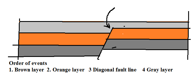
The diagram shows the Claron to be of equal thickness on both sides of the fault, but what I was saying was that there should be uneven deposition at that point, more on one side of the fault, less on the other, after a fault has shifted the layers relative to each other. Such as here where the gray layer is more on one side and less on the other:
Not necessarily. Just think if the fault continued up into an even younger layer. You still have the fact that the lower strata are more warped than the Claron. In fact, I wouldn't be surprised if the fault is part of the reason that the Claron formed in a lake on the north side. That might result in a thicker formation on that side...
The Claron looks like it was already there in its complete form, and there is a partial layer above it too, is that lava? and the fault line simply split the whole thing right to the top. No evidence of deposition going on at the time at all that I can see. Just a good example of layers tilting beneath one that remains horizontal.
Yes, the fault was probably active during deposition. That would give you the scenario that you describe.
But as I say above I don't see any evidence that the Claron was deposited after the fault occurred. Looks to me like it and the deposit on top of it were bisected by the fault.
You mean after the most recent movement on the fault. Again, YECS need to think about processes, not just end results.
Except that there isn't the unevenness of thickness I said should be expected. The two sides of the Claron are identical, and there is even a deposit on top of it that was already there too.
It isn't necessary to have uneven deposition, though it is common.
Again I see this formation as evidence for my argument rather than yours.
Not really. Growth faults always exhibit increasing offset and deformation with depth. That's practically the definition of a growth fault. In this case the uplifted part of the Claron is still cut by the fault but instead of being eroded away, the volcanic cap (probably on both sides) preserves its thickness. Besides, you're looking at a regional section here. I wouldn't put too much stock in the details.
I'd prefer to say it is an hypothesis, but I really do think I've supplied a fair amount of evidence for it.
Again, not really. Everything you describe is well within the realm of known geological processes.
|
|||||||||||||||||||||||||||||||||||||||||||
|
edge Member (Idle past 1737 days) Posts: 4696 From: Colorado, USA Joined: |
We would?
I knew you would quibble over this. But yes, according to you, during runoff, the flood removed the top layers of sediments that it also previously deposited. I am drawing an analogy between that and the Amazon Basin which is the closest thing that we have to a global flood. And yet when the runoff flows to the sea, it actually carries very little sediment by comparison to other major rivers of the world. Where did that sediment go? It stayed in the basin.
Explain what?
Where did the sediment go? Edited by Adminnemooseus, : Fix first quote box - Was a "/" at the first qs.
|
|||||||||||||||||||||||||||||||||||||||||||
|
edge Member (Idle past 1737 days) Posts: 4696 From: Colorado, USA Joined: |
he diagram shows the Claron to be of equal thickness on both sides of the fault, but what I was saying was that there should be uneven deposition at that point, more on one side of the fault, less on the other, after a fault has shifted the layers relative to each other. Such as here where the gray layer is more on one side and less on the other:
Actually there is a bit of an error here. Your sequence should be: 1. Deposition of brown layer2. Deposition of orange layer 3. Motion along fault 4. Deposiition of lower gray layer 5. Continuation and cessation of motion on fault 6. Deposition of upper gray layer The only assumption I'm making here is that the brown and orange layers are more offset and deformed than the gray layer (which seems to be the case).
|
|||||||||||||||||||||||||||||||||||||||||||
|
|
Do Nothing Button
Copyright 2001-2023 by EvC Forum, All Rights Reserved
![]() ™ Version 4.2
™ Version 4.2
Innovative software from Qwixotic © 2024

 (1)
(1)