|

Understanding through Discussion |
|
|
Register | Sign In |
|
QuickSearch
| Thread ▼ Details |
|
Suspended Member (Idle past 1474 days)  Posts: 35298 From: Nevada, USA Joined: |
|
Thread Info
|
|
|
| Author | Topic: Motley Flood Thread (formerly Historical Science Mystification of Public) | ||||||||||||||||||||||||||||||
Faith  Suspended Member (Idle past 1474 days) Posts: 35298 From: Nevada, USA Joined: |
YOu can't tell that an illustration of extinct animals purported to be romping in a time period called the Jurassic is a fiction? My evidence is that everybody knows that.
But shouldn't science and scientists be required to produce this sort of information before a mere layperson is nagged to death about it? Edited by Faith, : No reason given.
|
||||||||||||||||||||||||||||||
|
Faith Suspended Member (Idle past 1474 days) Posts: 35298 From: Nevada, USA Joined: |
You've never explained how tectonic forces could push around some strata without affecting adjacent strata. I've referred to the example of the tablecloth trick of removing it without disturbing the objects on top of it. And I also mentioned in Message 156 a real bona fide official certified geologist's comment that the Laramide Orogeny lifted the land without tilting the strata.
Would it be unreasonable if we just want to see the evidence spelled out because your usual presentation makes bald assertions about things you couldn't possibly know about (if this sentence looks familiar its because it's basically the same sentence you wrote at the beginning of your second paragraph in Message 1). Well, if it's now acceptable for presentations of supposedly known science to treat things they can't know as fact but remember the point is that they act like they ARE fact and that's the problem Butcertainly it ought to be acceptable for a mere creationist like me to simply describe what seems to me to be the best scenario to account for the Flood and don't yet have what I think of as fact, just hypotheses . That's what I'm trying to do, describe what I think probably happened, I'm not a scientist, I'm not selling a magazine and I'm not in any position to mystify the public. When I say the initial breaking up of the uppermost strata were probably loose sediment I expect a person of minimal intelligence to recognize it as logical and likely since there couldn't possibly be any evidence for such an event. You are free to say why you don't think so. You are nitpicking here to no good purpose except to try and wear me out. I have no idea what made the draining of the Flood possible so I mentioned what I think some creationists have argued, that the sea floor dropped, on the idea that water had been released from beneath the floor in the "fountains of the deep" to cover the earth, and when it drops into the vacuum left, the water has room to fill up the oceans.
The water level starts going down. But it's a pretty slow process, takes five months or so as I recall to completely drain away. Yeah, sounds like a really catastrophic receding of the waters capable of etching deep canyons. As it starts draining the uppermost layers break up.Five months of draining of, let's say, five miles of water is a lowering of water level of about an inch and a half per minute. Does that really sound like enough to etch canyons to you? The water acquires force when it has obstacles in its path and lower levels that open up as it recedes. If you follow the scenario you will come to the point where water is pouring into the cracks and then into the canyon. Edited by Faith, : No reason given. Edited by Faith, : No reason given.
|
||||||||||||||||||||||||||||||
|
Faith Suspended Member (Idle past 1474 days) Posts: 35298 From: Nevada, USA Joined: |
No they don’t have to be exposed and cleaned off. And there won’t be anything living there when the sediment lithifies because it is deeply buried. That shouldn’t be hard to understand. Yet somehow you keep failing to do that. To become a rock in the geo column it's going to have to be cleaned off because so many of those contacts are clean and tight. If things are living way above this lithifying rock, on what I would assume would be normal soil with normal plants and normal hills and valleys and other normal features of an actual landscape, there is no way it will ever become a rock in the geo column, but it has to become a rock in the geo column because that's what we actually see that supposedly points to the landscape. You can't leave it buried with animals romping on it, or in the case of sea creatures swimming over it. somehow you've got to have an actual rock with other rocks on top of it, and that can't possibly happen while anything is living in any of those "time periods." Edited by Faith, : No reason given.
|
||||||||||||||||||||||||||||||
|
Faith Suspended Member (Idle past 1474 days) Posts: 35298 From: Nevada, USA Joined: |
So do you at least agree that this mountain was eroded out of a large area of stacked flat sediments just like those it is made of?
ABE: Do you happen to recognize the mountain or the area? Would you happen to know just how much area the stacked sediments would have covered out of which the pretty mountain was eroded? Edited by Faith, : No reason given. Edited by Faith, : No reason given.
|
||||||||||||||||||||||||||||||
|
Faith Suspended Member (Idle past 1474 days) Posts: 35298 From: Nevada, USA Joined: |
Faith writes: And I also mentioned in Message 156 a real bona fide official certified geologist's comment that the Laramide Orogeny lifted the land without tilting the strata. Please provide a reference. I'm not sure you got that correctly. Message 147 Video at 13:47 but start a few seconds earlier to get the context. I think the geologist's name is Karl Karlstrom or something like that
|
||||||||||||||||||||||||||||||
|
Faith Suspended Member (Idle past 1474 days) Posts: 35298 From: Nevada, USA Joined: |
Such nice straight flat layers, ... Yes, flat lake and seafloors are pretty common. Not that straight and flat. I'm not trying to be difficult I just really can't see it as you see it. Those lines are really really really straight and flat and the contacts are very tight which doesn't seem to me to describe lake bottoms and sea floors, really. Is there anything about any of these layers that says "lake bottom" or "sea floor" to you besides the flat straight contacts? Here's the mountain for reference:
These are rocks (though not very lithified), not time periods. Sure they were deposited at different times, but they, themselves are not time periods. But surely they belong to a time period so I wonder which one. Mesozoic era perhaps?
And what a weird thought that the whole geologic column got stacked up like this with a flat top to it BEFORE the erosion turned it all into mountains and canyons and cliffs and hoodoos and monuments and arches and other interesting shapes...
Yes, that would be weird. But I think true nevertheless, and in fact probably the main evidence that the geological column is over and done with. I know you have other explanations, this is one of my view that gets answered over and over again as I'm often reminded, but I still see it this way and hope eventually to find the smoking gun evidence. Though I think there's pretty good evidence for it already, just not complete. That is, we've got all kinds of interestingly stratified geological objects out there from mountains to buttes to hoodoos to the Grand Canyon, all carved by erosion out of what was originally a great expanse of stacked sediments, and it just seems that the layers are mostly all neat and parallel and tight and eroded ONLY, carved ONLY, shaped ONLY after they were all laid down originally horizontally. Yes I know there are many partial stacks in many places, that my favorite Grand Canyon / Grand Staircase is really the only area I know of where they are ALL there, and yes I know the stacks are local and that the geo column is conceptual because it doesn't exist exactly the same in any one place, but nevertheless they are always (with the one exception of angular unconformities) found in these straight or at least parallel tight layers whether stacked horizontally or tilted or twisted into a pretzel, layers obviously originally stacked up one on top of another before being eroded into shapes or twisted into pretzels. This is all evidence that the strata were all there before being disturbed in any way, which is evidence for rapid deposition, for the Flood, and against the Time Scale. Even where partial they must all originally have represented the whole Geological Time Scale but lost a lot of upper strata in the Big Continent-splitting Tectonic Bash. Yes I know you explain this differently and my evidence is lacking because of the incomplete columns in spite of the complete ones. Smith's cross section of England is one comlete one, the entire column all laid down and then tilted. I know you explain all this differently but to me it's all evidence that the geo column couldn't possibly be explained by time periods of millions of years..... But anyway.... Edited by Faith, : No reason given.
|
||||||||||||||||||||||||||||||
|
Faith Suspended Member (Idle past 1474 days) Posts: 35298 From: Nevada, USA Joined: |
The total lack of any alignment of the canyon with a tectonic fault line is evidence against this big crack model Faith is espousing. The concept came from this cross section
The canyon is cut into the south side of the rise shown clearly in the diagram, up and over the strata. The rise has been identified as the Kaibab uplift in many discussions here. The uplift obviously occurred according to the cross section, after all the strata were in place. Since there was another mile or two of strata above the current rim of the Grand Canyon, which is agreed to by standard geology, and evidenced by the Grand Staircase to the north and the butte to the south, the rise would have put strain on the uppermost strata high above the current rim. That's how the cracks developed in my scenario. Two miles above the current rim. And since this is going on just at the beginning of the draining of the Flood waters, it seems logical that the water, soon laden with chunks of strata, would have widened and deepened the cracks until they became a channel for the recedeing water that eventually became the Grand Canyon. You have to account for those extra miles of strata in your scenario too. Edited by Faith, : No reason given. Edited by Faith, : No reason given.
|
||||||||||||||||||||||||||||||
|
Faith Suspended Member (Idle past 1474 days) Posts: 35298 From: Nevada, USA Joined: |
I didn't say anything about fractures, just cracks in the strata high over it that became the channel for the flood water to cut the canyon when it got down to that level..
I would like your answer to the post about the layered mountain though.
Message 284 Edited by Faith, : No reason given.
|
||||||||||||||||||||||||||||||
|
Faith Suspended Member (Idle past 1474 days) Posts: 35298 From: Nevada, USA Joined: |
Thank you.
I said the uppermost strata were cracked, not the canyon.
|
||||||||||||||||||||||||||||||
|
Faith Suspended Member (Idle past 1474 days) Posts: 35298 From: Nevada, USA Joined: |
The Colorado River's sinuous course has no relationship to cracks in any strata. That is practically the definition of a meandering stream. No idea what you have in mind here about meanders. And I'm not picturing a crack the whole length of the canyon, just over the Kaibab Uplift. Water does the work of carving the canyon.
And why are these rocks cracked anyway. I thought they were sort'a, kind'a soft, but not so much soft. Please describe the process of cracks forming in these rocks. ' Strata were laid down three miles deep or so by the Flood, two miles of it above what is now the Kaibab rim of the canyon. Strata are all underwater. They've been sitting there maybe a couple of months before the Flood starts to recede, but the uppermost would be soft. The uplift causes the upper ones to crack because they're soft. It's only about the level of the Kaibab that they are compact enough to hold together, and that's two miles beneath the uppermost layer.' The water starts at the same time the uplift is created. Whole stack is pushed upward in that area from beneath the canyon to the top of the three miles worth of strata, as indicated on the cross section, which you called the Kaibab Uplift at some time in the past. The uppermost strata on top of this three-mile stack are cracked by the strain of the uplift. You know, it forms a rise or a mound. That would strain the uppermost strata. That's what causes the cracks. And yes I would assume those uppermost strata were pretty soft because they didn't have any weight on them to consolidate them. But there would be greater and greater compaction in the layers below the uppermost ones as you go down iin the stack. The receding of the water starts breaking it all up. The uppermost ones probably break up into loose sediments but the lower down the water goes the chunkier the strata will be. It may take a month or two for it to get down to the level of the canyon but the cracks would be widening in the process. So I guess it would be a big crack in the end at the canyon level, as you say. This is in the south side of the Kaibab Uplift where the canyon forms. Can't imagine that any evidence would remain of that process after four thousand years: what evidence would you be expecting to .see? And what is the standard explanation for how the Colorado River got through the barrier of the Kaibab Uplift? My scenario has the virtue of solving that problem. Other subject: You answered one of the posts about the layered mountain but I was referring to another which you didn't answer. And please explain what it means to say that isn't a mountain but badlands. Edited by Faith, : No reason given. Edited by Faith, : No reason given. Edited by Faith, : No reason given.
|
||||||||||||||||||||||||||||||
|
Faith Suspended Member (Idle past 1474 days) Posts: 35298 From: Nevada, USA Joined: |
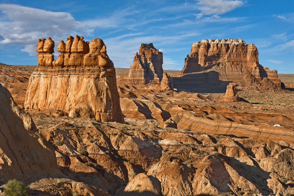
Talking still about this whatever it is: If it's not a mountain I want to call it a formation but that word is used for something else so what should it be called?
Anyway, you interpret the layers in this whatever-it-is as lakebeds:
Those are eroded continental lakebeds composed mostly of volcanic ash. They are not laterally extensive and are not mountains, they are badlands. I want to avoid terms like "absurd" if possible because I know it doesn't accomplish anything. When I started using it I didn't intend it as namecalling but that's how it gets taken. I actually think it conveys something about the image to call the usual interpretations absurd but if it's only heard as namecalling it doesn't convey much. So now I feel like begging and pleading with you to see how those cannot possibly represent lakebeds. I don't suppose that would do much good either though. If I just assert that they can't be lakebeds, or whatever the topic of the moment is, you often say something like "why not?" even if I think I've already said why, or mock me as pretending to be an expert and all that. But seriously those cannot be lakebeds. Why? What I keep saying: The contacts are too sharp, the lines are too straight and flat, no lakebed is that flat, no it is not, please don't act is if you think it is. Like Percy's pictures of fields and plains, no no no, the strata are way too straight and flat, no no no, those don't work and really it should be easy enough to see that, I keep being amazed that it isn't. Everything I say becomes an insult but I can't figure out how to prevent that, I just want you to see that those straight flat layers with their very uniform-looking sedimentary content cannot possibly be lakebeds. This has got to be some spell they put geologists under in graduate school. They teach this stuff and you have to believe it and you earnestly learn it. Of course the teachers are under the spell in the first place. Whatever this object is, and I still keep wanting to call it a formation, same as I want to call the hoodoos and the monuments and the arches and the stairs of the GS and even the Grand Canyon, I need a name for it, but anyway, the most important point is the one above, that the strata cannot possibly be lakebeds, but also I have to note again that the fact that these various objects are made of strata and then eroded into their shapes is evidence against the Time Scale, for rapid deposition of the strata and for the argument I keep trying to make about how the Geological Column is over and done with. They are evidence that the strata were all laid down before the erosion occurred, or the tectonic deformation in other cases and so on. I know you want to point to the short versions of the column to refute me but don't just jump on that yet please. There's the Grand Canyon and Grand Staircase together to make up the entire column, and the William Smith cross section of England too, which I mention in Message 284. Getting this across is usually futile too because you have your different interpretations that you are so used to, and it's all official Geology so nothing I say can make much of a dent in it. Just want to post a couple other pictures of similar "formations" made of strata: From Message 2833:Picture of Entrada beneath Curtis formation, showing straightness/flatness and tight contact:
Picture below: Carmel formation shows nice straight layers eroded into monuments in Goblin Valley.
Edited by Faith, : No reason given.
|
||||||||||||||||||||||||||||||
|
Faith Suspended Member (Idle past 1474 days) Posts: 35298 From: Nevada, USA Joined: |
It doesn't matter if that is a mountain or not, though it's interesting to read about it; I'm mainly interested in how stratified things get formed into shapes, but thank you for the reference; all I could find is that blog source for the image.
|
||||||||||||||||||||||||||||||
|
Faith Suspended Member (Idle past 1474 days) Posts: 35298 From: Nevada, USA Joined: |
The only reason that the Coconino Plateau exists is because the Grand Canyon cuts the Kaibab Uplilft into two parts. Does that mean the Coconino Plateau is not Coconino sandstone as I'd thought?
|
||||||||||||||||||||||||||||||
|
Faith Suspended Member (Idle past 1474 days) Posts: 35298 From: Nevada, USA Joined: |
There are a lot of posts here I may never get to even if I want to. My eyes have recently gone from bad to worse and I have to rest them frequently. Just so you know I'm not just "running away."
|
||||||||||||||||||||||||||||||
|
Faith Suspended Member (Idle past 1474 days) Posts: 35298 From: Nevada, USA Joined: |
Just came back and see this complaint by both Percy and edge about no such thing as a complete geological or stratigraphic column. I remember pretty much what I said though I'll have to reread it to be sure, but my first take is it doesn't matter, why on earth does it matter, I'm not claiming absolute completeness, that's not the point, but there are places where the whole range from Cambrian to Holocene is represented in the rocks and that's what I'm talking about. The Grand Canyon is missing the Silurian I believe, but England has all of them IIRC, Cambrian Devonian, Silurian, Carboniferous, Permian, Triassic, Jurassic, Cretaceous and Quaternary. I hope I didn't forget one. I know the rocks differ in different places but they always everywhere represent the same time scale through their fossil content. That would be all I mean by the whole column's being represented in a couple of places, that you can see most of the time periods represented all the way from the Cambrian -- actually the Precambrian --- to the Holocene. My point doesn't need detailed perfection. Good grief.
Edited by Faith, : No reason given.
|
||||||||||||||||||||||||||||||
|
|
Do Nothing Button
Copyright 2001-2023 by EvC Forum, All Rights Reserved
![]() ™ Version 4.2
™ Version 4.2
Innovative software from Qwixotic © 2024