|

Understanding through Discussion |
|
|
Register | Sign In |
|
QuickSearch
| EvC Forum active members: 65 (9164 total) |
|
| |
| ChatGPT | |
| Total: 916,913 Year: 4,170/9,624 Month: 1,041/974 Week: 368/286 Day: 11/13 Hour: 0/0 |
| Thread ▼ Details |
|
Thread Info
|
|
|
| Author | Topic: Did the Flood really happen? | |||||||||||||||||||||||||||||||
Faith  Suspended Member (Idle past 1474 days)  Posts: 35298 From: Nevada, USA Joined: |
"Surfaces" that are deep and flat and often of one single sediment containing specific collections of fossils, that extend for thousands of square miles do NOT get slowly buried every day. Good grief.
|
|||||||||||||||||||||||||||||||
|
Faith Suspended Member (Idle past 1474 days) Posts: 35298 From: Nevada, USA Joined: |
If it's impossible, then sorry, it didn't happen. What that means is that your theory is a crock. Face it.
|
|||||||||||||||||||||||||||||||
|
Faith Suspended Member (Idle past 1474 days) Posts: 35298 From: Nevada, USA Joined: |
Your deep burial scenario is impossible, that's the point. You have to end up with the geological column and that won't accomplish that, nor will any scenario you could dream up. Interesting of course how all you do is attack me personally. You can't make any scenario work so you attack me.
Edited by Faith, : No reason given.
|
|||||||||||||||||||||||||||||||
|
Faith Suspended Member (Idle past 1474 days) Posts: 35298 From: Nevada, USA Joined: |
None of that could possibly create the geological column.
|
|||||||||||||||||||||||||||||||
|
Faith Suspended Member (Idle past 1474 days) Posts: 35298 From: Nevada, USA Joined: |
Oh I don't deny that layers are forming in the oceans, but they couldn't ever look like the geo column, not to mention that changing locations is a huge deception. You are all kidding yourselves.
|
|||||||||||||||||||||||||||||||
|
Faith Suspended Member (Idle past 1474 days) Posts: 35298 From: Nevada, USA Joined: |
Geo column not confined to disparate bodies of water, it extends over thousands of square miles straight and flat, no shape of curved bottoms of bodies of water. I shouldn't have to describe this, your denial ought to offend even you. Different sediments in different places but no signs of the shapes of lake bottoms or river bottoms etc. There is no comparison whatever between the geological column which is a stack of flat mostly separated sediments that is found all over the world and not in bodies of water but everywhere.
Edited by Faith, : No reason given.
|
|||||||||||||||||||||||||||||||
|
Faith Suspended Member (Idle past 1474 days) Posts: 35298 From: Nevada, USA Joined: |
Way back in Message 448 HBD put up a few diagrams from a book of his that show four of the "time periods" as sedimentary rocks spreading across the entire North American continent. That is ONE of the places I get this idea.
Another source is a post here that I don't remember unfortunately that quoted some expert as showing that cores all across the Midwest to West USA show the same strata to some great depth. Certainly wish I could find that. The Mountains of course interfere and to the East the tectonic disturbances of the land through the Appalachians also interfere. Your seismic info contradicts all the strata ever illustrated. ABE: Trying to track down the cores sources. Find that I refer to it in Message 276 so I'll keep looking further back. Think I've found it: Message 275 I see I also mention it in Message 279 Edited by Faith, : No reason given. Edited by Faith, : No reason given. Edited by Faith, : No reason given. Edited by Faith, : No reason given. Edited by Faith, : No reason given.
|
|||||||||||||||||||||||||||||||
|
Faith Suspended Member (Idle past 1474 days) Posts: 35298 From: Nevada, USA Joined: |
I'm amazed: I didn't expect to find the source of that quote but I did. ThinAirDesigns posted it in Message 275 on a thread titled "The Great Creationist Fossil Failure" as an answer to something George McReady Price had written, but he doesn't give the source that I can see. Here's the quote though, by a Harold Clark, whose info seems to oppose something Price said but gives even better evidence for the Flood:
Sound almost exactly like the position of one George McReady Price when Harold Clark, one of his prized students got off his ass and went to the field to compare what Price said against the evidence. Clark wrote back :
The rocks do lie in a much more definite sequence than we have ever allowed. The statements made in your book, The New Geology, do not harmonize with the conditions in the field. All over the Midwest the rocks lie in great sheets extending over hundreds of miles, in regular order. Thousands of well cores prove this. In East Texas alone are 25,000 deep wells. Probably well over 100,000 wells in the Midwest give data that has been studied and correlated. The science has become a very exact one. Millions of dollars are spent in drilling, with the paleontological findings of the company geologists taken as the basis for the work. The sequence of the microscopic fossils in the strata is remarkably uniform. The same sequence is found in America, Europe, and anywhere that detailed studies have been made. This oil geology has opened up the depths of the earth in a way that we never dreamed of twenty years ago. So this is what I've been picturing for years: extremely extensive rock layers spreading huge distances across the continent, at least the N. American continent but others as well. NOT strata found in lake or river basins but strata straight and deep across the land, not contained in small bodies of water. Apparently Price thought something else. It would be good to dig up the sources Thin Air is referring to. Meanwhile so much for your seismic data. Just the usual attempt to obfuscate the factds. Edited by Faith, : No reason given. Edited by Faith, : No reason given. Edited by Faith, : No reason given. Edited by Faith, : No reason given. Edited by Faith, : No reason given.
|
|||||||||||||||||||||||||||||||
|
Faith Suspended Member (Idle past 1474 days) Posts: 35298 From: Nevada, USA Joined: |
Some of you people need to get honest for a change and stop trying to muddy up this discussion. There is NO evidence whatever that any of the strata of the known Geological Column, abstract or not, local or not, has ever been shown to have sloping sides like a lake or a river bottom. They are ALL straight and flat, straighter and flatter than any lake bottom or riverbed, and cover hundreds to thousands of square miles, a lot more area than the biggest lakes known, both the marine and the terrestrial strata. Your illustrations of water bodies are utterly irrelevant and serve as nothing but obfuscation of the facts of the Geo Column itself. And the seismic data is also obviously irrelevant.
Hey Coragyps: Your field is oil, right? You know about the geology of oil country, you must know about this core information I refer to above, since it was necessary for finding oil, yes? Why are you taking the side of these obfuscators? Yeah I know you like the ancient earth crap, but look at the data about the strata itself. Edited by Faith, : No reason given. Edited by Faith, : No reason given. Edited by Faith, : No reason given. Edited by Faith, : No reason given.
|
|||||||||||||||||||||||||||||||
|
Faith Suspended Member (Idle past 1474 days) Posts: 35298 From: Nevada, USA Joined: |
There is plenty in what HBD says about this that I disagree with but I'll have to get to that in the next post. Meanwhile I thought it best to copy out his entire post with all his comments nevertheless. The diagrams certainly support what I'm saying against what others in this thread are arguing against me. Yes they are marine deposits but they are extremely extensive. I'll have to check on HBD's linked source to see if there are more diagrams.
Forum: Geology and the Great Flood
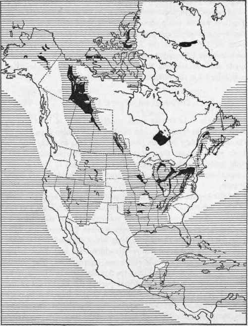
Topic: Why the Flood Never Happened Subtitle: Re: Palouse Canyon -- what extreme flood cascade flow does God trumps it all. Too bad some Christians give in so easily. I believe you have created a false dichotomy for yourself. For you, it boils down to either the Bible is wrong or the evidence is wrong. But perhaps there is a third option... remember that the Bible (specifically Genesis in context of this discussion) was not written to twenty-first century, scientifically knowledgeable people, but to bronze age nomads who had just left Egypt and who God intended to make into a great nation, the nation he promised Abraham. Yes, the Bible was written for us but not to us. You must understand the Bible in the context of its original audience. I won't go into it any further here, but suffice it to say that the third option might be that you simply misunderstand what the original intention of the passages were. If that position is correct then both the physical evidence and the Word of God can be true. It doesn't have to either / or. No dichotomy needed. Back to the topic at hand, I found these charts in An Introduction to Geology. Its kinda old (1921 ?) so I'm sure more evidence has been added since then but he has some good illustrations spanning the time period we are talking about (particularly the unconformity between the Muav limestone and the Redwall limestone. (hatched areas = known deposits, black areas = exposed areas) Now for the purposes of this exercise, there is no need to assign dates to any of the layers, simply to recognize that they were laid down sequentially and to note the pattern of distribution. The order is:Cambrian (there is not a distribution map available in this book), Ordovician, Silurian, Devonian, Mississippian.Ordovician:
Notice there is a large circular area near the beginning of the canyon that has no Ordovician deposits but all around it there are? What can you conclude from that? Consider that we are talking about that area being uplifted at some point in the past. Does that area look like it might be higher than the surrounding areas (that were seas)? Could that be why there were no Ordovician deposits - because the land was above sea level?Silurian:
Devonian:
Mississippian (Carboniferous):
Muav limestone is Cambrian. Ordovician and Silurian rocks are missing from the formation. Devonian is represented by Tempe Butte formation. And Mississippian is represented by Redwall limestone. Consider that the layers were laid down while they were under water (they are sedimentary rock after all). What do these distribution charts tell us about what the land was like during the times when the layers were being laid down? Bottom line is this ... How can a global flood explain these patterns of distribution? And how could that explanation do a better job of explaining this pattern than deposits made sequentially over an extended period of time (doesn't even need to be millions of years)?Another point. I live in Michigan and we are experiencing glacial rebound that has been measured to be up to 15 inches per century in the northern Great Lakes region! that is more than 1/8" a year! I've never even noticed it. No bedrock cracking, no problem with our rivers flowing. Uplift is not as big a problem as you think. Yea, if it lifts 10 feet in a year - that would be a problem. But not a couple inches a century. Our world is pretty flexible. HBD
|
|||||||||||||||||||||||||||||||
|
Faith Suspended Member (Idle past 1474 days) Posts: 35298 From: Nevada, USA Joined: |
Extensive deposits are GREAT evidence for a worldwide Flood, and it's hard to understand why anyone would think otherwise. And would there be a problem if they aren't completely continuous? We're talking about sediments carried in water after all, there's only so much of it, it runs out, it deposits in one place and not another, what is the problem? In ANY CASE THESE DIAGRAMS CONTRADICT THE LAKE BED AND RIVER BED FARCICAL ATTEMPTS AT EXPLANATION OF THE GEO COLUMN. THESE *ARE* THE STRATA OF THE GEO COLUMN, THEY ARE *NOT* CONFINED TO SMALL BODIES OF WATER. Edited by Faith, : No reason given.
|
|||||||||||||||||||||||||||||||
|
Faith Suspended Member (Idle past 1474 days) Posts: 35298 From: Nevada, USA Joined: |
As I have hypothesized many times in the past, Lake Bonnevilie is one of the large lakes we know existed at one time, including such as Lahontan and Missoula and a few others, that must have been left after the Flood for some period of time before draining away, perhaps as the result of natural dams breaking under the tectonic forces that were very active after the Flood. The famous "Bad Lands" of the NW that show serpentine drainage patterns lined by a depth of about three sedimentary layers, look to me like the drainage pattern from Lake Missoula.
In any case, even these large lakes are nowhere near the size we know to be the extent of the Geo Column strata, and there is NO EVIDENCE WHATEVER of the sloping edges in those strata that occur in lake beds or river beds as you are all trying to pretend. HEY, I'M WAITING FOR AN HONEST CLEAR-EYED POSTER TO SHOW UP AND SEE WHAT'S REALLY GOING ON HERE AND CALL "FOUL" ON THESE FALSE ARGUMENTS AGAINST THE FLOOD. WHERE ARE YOU, HONEST POSTERS? FORGET THE ARGUMENTS ABOUT HOW IT *COULD* HAVE HAPPENED THIS OR THAT WAY CONSISTENT WITH ESTABLISHMENT GEOLOGY. SO WHAT? IF YOU FORCE YOUR BRAIN TO DO CARTWHEELS AND STRETCH INTO PRETZELS IT WILL DO THEM FOR YOU BUT THAT ISN'T GOING TO GIVE THE HONEST ASSESSMENT CALLED FOR HERE. Edited by Faith, : No reason given. Edited by Faith, : No reason given. Edited by Faith, : No reason given. Edited by Faith, : No reason given.
|
|||||||||||||||||||||||||||||||
|
Faith Suspended Member (Idle past 1474 days) Posts: 35298 From: Nevada, USA Joined: |
I had just read up on glacial rebound when I saw your post. It doesn't belong on this thread, but it also doesn't have much to say about anything. The land rebounds or rises, the sea level rises, but it belongs on the thread about climate change so I'm not going to talk about it here. The subject here is how the strata of the geo column were NOT formed in isolated bodies of water. If you have nothing to say about that then take glacial rebound to the other thread,. Thank you.
Oh but there would be no Flood rebound because it drained into the vaccume left by the fountains of the deep beneath the sea floor when the water started rising. That's the theory of the moment. You might try to keep up, jar. I would also suggest that the rising of the land from the rebound would go a long way to counteracting the rising of the sea water. But again I'm not going to address this rabbit trail here. I'm sorry I mentioned it at all. If you want to pursue it take it to the other thread of ir you persist in your folly I'll take it there. Edited by Faith, : No reason given. Edited by Faith, : No reason given.
|
|||||||||||||||||||||||||||||||
|
Faith Suspended Member (Idle past 1474 days) Posts: 35298 From: Nevada, USA Joined: |
...
|
|||||||||||||||||||||||||||||||
|
Faith Suspended Member (Idle past 1474 days) Posts: 35298 From: Nevada, USA Joined: |
The topic WE ARE DISCUSSING is whether the geo column could have been formed in small bodies of water. That is what *I* am discussing, and my answer to Flood Rebound I already gave anyway, take it or leave it that's my answer.
|
|||||||||||||||||||||||||||||||
|
|
Do Nothing Button
Copyright 2001-2023 by EvC Forum, All Rights Reserved
![]() ™ Version 4.2
™ Version 4.2
Innovative software from Qwixotic © 2024