|

Understanding through Discussion |
|
|
Register | Sign In |
|
QuickSearch
| EvC Forum active members: 64 (9164 total) |
|
| |
| ChatGPT | |
| Total: 916,890 Year: 4,147/9,624 Month: 1,018/974 Week: 345/286 Day: 1/65 Hour: 0/0 |
| Thread ▼ Details |
|
|
| Author | Topic: Was there a worldwide flood? | ||||||||||||||||||||||||
|
RAZD Member (Idle past 1433 days)  Posts: 20714 From: the other end of the sidewalk Joined: |
I don't suffer from sea-sickness, but I wouldn't have wanted to be on the Ark with all that going on underneath me. Or after it landed if the continents were still combined then (gets animals from ark to australia, new zealand, hawaii, etc). Hyper-tectonics anyone? Heh. Of course all those earthquakes, shifting landmass, hyperevolution of species were recorded too ...  Enjoy. Edited by RAZD, : subtitle compare Fiocruz Genome and fight Muscular Dystrophy with Team EvC! (click) we are limited in our ability to understand by our ability to understand RebelAAmericanOZen[Deist ... to learn ... to think ... to live ... to laugh ... to share.
|
||||||||||||||||||||||||
|
RAZD Member (Idle past 1433 days) Posts: 20714 From: the other end of the sidewalk Joined: |
The neat part about the gravity control hypothesis, is that each species as it travels to it's new habitat can be protected by a gravity well so that there is no cross-over of species that shouldn't be there.
(Of course there should also be evidence of these well tracks across the bottom of the oceans, but that just needs a different interpretation of what the bottom sediment covers ...) All's 'well' that ends 'well'? Enjoy. compare Fiocruz Genome and fight Muscular Dystrophy with Team EvC! (click) we are limited in our ability to understand by our ability to understand RebelAAmericanOZen[Deist ... to learn ... to think ... to live ... to laugh ... to share.
|
||||||||||||||||||||||||
|
RAZD Member (Idle past 1433 days) Posts: 20714 From: the other end of the sidewalk Joined: |
Doesn't this kind of negate the need for 40 days and nights of rain? And you'd think the noticeably hummocky water would draw comment too... But that's the real beauty of the theory: the storm makes the "hummocky water" appear normal (and how "hummocky" it would be depends on location and visibility - a couple miles tops. See below). They aren't necessarily linked after all: http://www.genesis.net.au/%7Ebible/kjv/genesis/
quote: {abe}Ocean - Wikipedia quote: So 71% of the surface is on average 12,430 ft, so spreading that out to 100% of the surface would mean the average depth would be 8,825 ft (1.67 miles). That would take out most of the "hummocky" effect. Peaks like the Himalayas (Everest etc) would be averaged out into one huge slow rising mound hard to distinguish from the curvature of the earth. Fujiyama and Kilimanjaro might be seen as hills of water, but this would mean the ark was near them.{/abe} Enjoy. Edited by RAZD, : {abe} section Edited by RAZD, : mtns compare Fiocruz Genome and fight Muscular Dystrophy with Team EvC! (click) we are limited in our ability to understand by our ability to understand RebelAAmericanOZen[Deist ... to learn ... to think ... to live ... to laugh ... to share.
|
||||||||||||||||||||||||
|
RAZD Member (Idle past 1433 days) Posts: 20714 From: the other end of the sidewalk Joined: |
Hi Lysimachus,
Message 274That could pose a problem, I suppose. I've read arguments from creationists against this. Some have proposed that there was supernatural involved. Which, I predict, is where you will necessarily end up, if you insist on a world wide flood and honestly consider the evidence of long time no flood in so many areas of the world. For instance you can posit that god made the water flow over the land as it is, and end up with a much easier flood, but of course this is using the god-did-it excuse at the start.
The only question posed is, "were these mountains always there?" So regardless of whether a flood was in the picture or not matters little. Remember, the argument is that too much water would have been needed to cover these mountain peaks. I simply do not subscribe to the idea that the mountains were that high prior to the flood. And for good measure, mountains and islands are even being born today. Correct, and no, the mountains were not always there, and also there used to be mountains that no longer exist, and there are mountains that are very worn down now compared to the (relatively) newcomers. These mountains form and erode on geological time, and when we compare the rate of geological time to grow a mountain like Mt Everest we find that the current growth of (growing) mountains is very similar to the rates of growth measured today - at Everest and other locations around the world.
Message 274 ... or as a result of the seismic upheavel caused by the flood? Curiously, water doesn't push mountains into existence. Water is less dense than rock. Now, you can of course, say that there was a supernatural cause for the seismic upheaval, in which case we've already gotten to the god-did-it excuse. If you form the hard surface of the earth into a perfect oblate spheroid, then there is sufficient water to cover it, however you don't have the time nor a mechanism to form the mountains from that perfect oblate spheroid with known geological processes. Speeding up the processes creates more problems than it solves, as the friction would be sufficient to melt the rocks that you are trying to pile up, and your foundation collapses. In the end it requires supernatural means to accomplish in the time span YEC's insist on, so again you are already at the god-did-it excuse.
Message 274It is my theory that these mountains were pushed up after the flood, since the earth was still suffering seismic after-shocks. No, it is your ad hoc conjecture that this occurred. A theory has to be based on evidence and have a testable conclusion. The amount of seismic activity needed to form the known mountains in the time period of a few thousand years would be sufficient to cause the mountains to crumble and fall as fast as they formed.
Did the rest of the water partly vaporize and also settle into the earth as we know it? Interestingly, the earth is not saturated with water, and there is a lot of void area inside the rocks and soil to take up a lot of water before flooding would occur. Fascinatingly, water doesn't "partly vaporize" there is no middle ground between liquid and gas phases (or the solid phase). Vapor doesn't "settle into the earth" it rises into the air. Which -- seeing as any time the air gets sufficient concentration it condenses and falls as rain, eventually running back into the oceans, AND as the total amount of moisture in the air right now is insufficient to cause the ocean to rise 1 foot -- doesn't solve the problem.
Message 274In addition to this, let us not fail to recognize the fact that sea fossils have been found on the peaks of very high mountains. Indeed. Fossils of organisms that, amazingly, make up layer after layer after layer of undisturbed mature marine ecosystem growth, including organism in every layer that are 5 to 50 years old. See Trilobites, Mountains and Marine Deposits - Evidence of a flood? for more on this:
quote: Can you explain how this is evidence of a brief flood? Enjoy. Edited by RAZD, : no by our ability to understand Rebel American Zen Deist ... to learn ... to think ... to live ... to laugh ... to share. • • • Join the effort to solve medical problems, AIDS/HIV, Cancer and more with Team EvC! (click) • • •
|
||||||||||||||||||||||||
|
RAZD Member (Idle past 1433 days) Posts: 20714 From: the other end of the sidewalk Joined: |
hey peg, bluescat48, lyx2no2, etc,
Could you give me the reference to the above?
here is a link to the articleLake Rudolph Skull Fragments This is an old newspaper article about the finding of a skull now known as Homo rudolfensis, and you can compare the pictures of the skull in the article to the one here: Anthropology | Smithsonian National Museum of Natural History
quote: This is "F" in the picture below: 29 Evidences for Macroevolution: Part 1
quote: Message 303well the sediments are not consistent in the case of the Omo valley and Lake Rudolph. Even though the fragments Richard Leakey found were dated to 2.5 million years old, the skull was the same shape as modern man. He said that other bone fragments that were found such as the leg specimens were indistinguishable from the same bones of modern men. but they were still dated to be 2.5 million years old. As you can see from the above picture, the skull is clearly placed at an intermediate level of development along the trend of evolution from (B), Australopithecus africanus to (N), Homo sapiens, or (M) Homo sapiens, CroMagnon, at 30kyr old. Further you can compare it to this 160,000 year old Homo sapiens skull and see that even then the brain capacity was significantly greater than is exibited by Homo rudolfensis: http://www.berkeley.edu/.../releases/2003/06/11_idaltu.shtml
quote: These Homo sapiens skulls fit between (I) and (M) in the picture above (J, K and L being neanders), close to (M). Enjoy. Edited by RAZD, : s Edited by RAZD, : time for bed Edited by Admin, : Shorten long link. by our ability to understand Rebel American Zen Deist ... to learn ... to think ... to live ... to laugh ... to share. • • • Join the effort to solve medical problems, AIDS/HIV, Cancer and more with Team EvC! (click) • • •
|
||||||||||||||||||||||||
|
RAZD Member (Idle past 1433 days) Posts: 20714 From: the other end of the sidewalk Joined: |
Curiously I can reduce it to three words with |G _ _ | _ _ _ | _ _ | ... the usual YEC end gambit,
god did it or to two words with: | _ _ _ | _ _ _ _ _ _ _ | ... for the rest of us.
try reality Let's play hangman eh? Enjoy. Off-topic blather hidden - Adminnemooseus Edited by Adminnemooseus, : No reason given. Edited by Adminnemooseus, : No reason given.
|
||||||||||||||||||||||||
|
RAZD Member (Idle past 1433 days) Posts: 20714 From: the other end of the sidewalk Joined: |
Hi Peg, still having that denial problem eh?
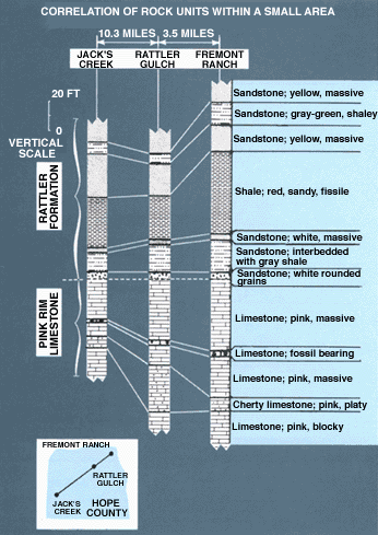
I was not calling into question geology as a whole....even though the geologic column IS a hypothetical structure. Actually it is a validated theoretical structure. In science you move from evidence to hypothesis that explains the evidence to tests of the hypothesis with new evidence or experiments to validation of the tests or to invalidation of the hypothesis from the results of those tests. One of those tests consists of a simple comparison of existing undisturbed sedimentary layers: if layer A is above layer B in one location, then whenever you can find both layer A and layer B in other locations, A will be above B. Another test is that where layer A is above layer B and layer B is above layer C, then whenever you can find layers A and C - with or without B (it may not extend as far as the other layers) - layer A will be above layer C. This sequential layering is what forms the "geological column" even though there may be no one place where all the layers exist. An example of this kind of layering is shown here: http://pubs.usgs.gov/gip/geotime/correlation.html
quote: This has been massively tested and massively validated, as geologists have been doing this comparison for centuries, it is so massively tested that it is known as the Law of Superposition: Law of superposition - Wikipedia
quote: And the top of each layer determines the shape of the bottom of the next layer above. This provides another way to test the concept: if layer A deforms layer B then it would be the first formed first to harden layer. A third way that this concept has been tested is with radiometric dating: if the law of superposition is correct then the radiometric dating should show a progression of ages from oldest at the bottom to youngest at the top. Are Radioactive Dates Consistent? (4)
quote: Layer by layer the stratigraphic measures older by radiometric dating, entirely consistent with the long term deposition of sedimentary layers (and not some jumbled debris of some fantasy flood scenario). None of the K-Ar Dates overlap into the wrong sedimentary layers. This same kind of layering, with oldest layer first, also occurs in limestone and calcite deposits, in stalactites and similar formations. These formation also trap radioactive isotopes that then decay, with the most decayed layers being the oldest first layers of the deposits. Thus the law of superposition is validated in many ways, in many locations, for many many years. Enjoy. by our ability to understand Rebel American Zen Deist ... to learn ... to think ... to live ... to laugh ... to share. • • • Join the effort to solve medical problems, AIDS/HIV, Cancer and more with Team EvC! (click) • • •
|
||||||||||||||||||||||||
|
RAZD Member (Idle past 1433 days) Posts: 20714 From: the other end of the sidewalk Joined: |
content mooved to appease the moose
See Message 24 Edited by RAZD, : mooving Edited by RAZD, : linked by our ability to understand Rebel American Zen Deist ... to learn ... to think ... to live ... to laugh ... to share. • • • Join the effort to solve medical problems, AIDS/HIV, Cancer and more with Team EvC! (click) • • •
|
||||||||||||||||||||||||
|
|
Do Nothing Button
Copyright 2001-2023 by EvC Forum, All Rights Reserved
![]() ™ Version 4.2
™ Version 4.2
Innovative software from Qwixotic © 2024